

Colour your Daily Forecast - Mar 2 - Wally's Weather Australia
- Mar 1, 2025
- 14 min read
We're thrilled to welcome Painting Professionals as our Leading Sponsor for the next 8 months, Daily, Monthly and Long Range Forecast!

We specialise in being the best of the best period.
The old saying "you get what you pay for".
We definitely aren't the cheapest and don't claim to be.
But if you want the best quality, with the best quality paints, backed with a 12 year year warranty!
Then get in contact with the team and see what we can do for you.
SPECIAL OFFER
15% discount for all wally members. And 15% discount for all ADF and emergency service personnel.
Ph +61 417 065 781
National Synoptic Situation
National Temperature and Rainfall

Rain typically refers to steady, continuous precipitation that lasts for a longer period, sometimes hours or even days. It can vary in intensity, but it's usually more consistent and widespread.
Showers, on the other hand, are shorter bursts of rain, often intermittent. They can be heavy but usually don't last long. Showers are more sporadic and may be followed by dry periods or other types of weather, like sun or clouds.
National Synoptic Situation
QLD:
Well, it looks like Mother Nature is feeling a bit lazy with a weakening ridge over southern Queensland and a weak pressure gradient elsewhere in the state. Meanwhile, Severe Tropical Cyclone Alfred is just chilling out in the Coral Sea, causing some extra windy and wavy conditions along the central and southern east coast. Don't worry though, Alfred is planning to keep its distance and stay offshore over the weekend and into next week as it casually moves southwards. But hey, keep an eye out mid-next week just in case it decides to make a surprise appearance on the southeast coast. As for the southwest, there's a trough hanging out in the interior for a few days, just lounging around and not really doing much. So, grab your umbrella and sunscreen, folks, and enjoy the laid-back weather while it lasts.
NSW and ACT:
So, it looks like we've got some trough action happening in northwestern New South Wales, with another one fizzling out over the central coast. Keep an eye out for a southerly change coming to the southern half of the coast on Sunday, thanks to yet another trough. And just when you thought it couldn't get any better, a cold front will be passing to the south as well. Meanwhile, a high-pressure ridge will be chilling in the south of the state. Oh, and let's not forget about our friend Severe Tropical Cyclone Alfred, who will be making its slow and dramatic entrance into the southern Coral Sea. So, get ready for some weather shenanigans, folks!
VIC:
Well, it looks like Victoria is in for a bit of a weather rollercoaster this week. A weak cold front is expected to saunter past south of Victoria on Saturday, followed by a high pressure system swooping in to reinforce a southerly airstream on Sunday. Monday will bring some south to southeasterly winds, while Tuesday will see a shift to more east to northeasterly breezes as the high moves towards the Tasman Sea. But wait, there's more! Another feeble front is poised to glide south of Victoria on Wednesday, just in time for the next high in the Bight to build a ridge east over the State on Thursday. This will result in a more southerly airstream sweeping across Victoria. So, get ready to hold onto your hats, folks!
SA:
Well, it looks like we've got a ridge of high pressure hanging out to the south and a stubborn trough loitering up northeast. On Sunday, a high pressure system will decide to make itself at home south of the Bight while the pesky trough finally moves on towards Queensland. Next week, the high will casually saunter southeast before another high sets up shop south of the Bight. Just your typical weather shenanigans.
WA:
Well, isn't that just great? We've got ourselves a lovely broad low pressure trough hanging out over northern WA. Just what we always wanted, right? So, in case you were wondering, that means we can expect some less-than-ideal weather conditions in that area. So, if you happen to be in northern WA, you might want to prepare yourself for some not-so-great weather. Just a little heads up for you all.
TAS:
Get ready for some weather whiplash as a cold front swoops in from the west later in the evening. Brace yourself for some northwesterly winds before a sneaky southwesterly change creeps up behind it. A high will swoop in over the state on Sunday and Monday, bringing some stability to the chaos. But don't get too comfortable, because by Tuesday a warm northeasterly wind will start blowing as the high saunters off to the east to hang out over the Tasman Sea. Just when you thought you had it all figured out, a weak trough will slide in from the west on Wednesday, mixing things up once again. Mother Nature sure does have a sense of humour, doesn't she?
NT:
Well, it looks like Mother Nature is playing a little game of tug-of-war over the Northern Territory. A weak ridge up north is bringing in some dry air, making showers and thunderstorms feel a bit left out as they become more isolated. Meanwhile, a feeble trough down south is just chilling. But hold onto your hats, because on Sunday a high from the Bight is coming to town and will flex its muscles, pushing that lazy trough up north into central districts. Time to buckle up and enjoy the ride!
National Weather Warnings
New South Wales
No warnings available at this time for New South Wales.
Victoria
No warnings available at this time for Victoria.
Queensland
Western Australia
South Australia
Tasmania
Northern Territory
National Storms and Rain Accumulation outlook


Four Day Forecasts
If you run a business and would like the benefits of a Big Shout plus your business promoted for 365 days, head here to take out a Bold Shout for $250.


NQ Rainfall 24 Accumulated (ACCESS G) PLUS one day


Monsoon Update
If you have or had a Big Shout, make sure you keep your card updated. Login, select Profile, Select Wallet and update your details https://wallysweather.com.au
Severe Tropical Cyclone Alfred is now looking more and more a sure thing to cross around the Sunshine Coast with the SW edge of the eye, most likely a Category 1, possible 2. Below tells the story of the rain over 24 hours, the wind as it approaches and the gusts as it touches the coastline.
These are the expected differences with respect to damage from the different categories:
Category 1
Damaging winds. Negligible house damage. Damage to some crops, trees and caravans. Craft may drag moorings.
Maximum mean wind speed 63–88 km/h.
Typical strongest gust is up to 125 km/h.
Category 2
Destructive winds. Minor house damage. Significant damage to signs, trees and caravans. Heavy damage to some crops. Risk of power failure. Small craft may break moorings.
Maximum mean wind speed 89–117 km/h.
Typical strongest gust 125–164 km/h.
Category 3
Very destructive winds. Some roof and structural damage. Some caravans destroyed. Significant damage to crops and trees. Power failures likely.
Maximum mean wind speed 118–159 km/h.
Typical strongest gust 165–224 km/h.
Below are row 1 Rainfall over 24 hours, row 2 average wind speed as it approaches and row 3 wind gusts as it touches the coast. You can see the location is pretty clear, although another 4 days movement may shift it about a bit. The columns are ECMWF, GFS and ACCESS(BOM)


I have popped the markers on the wind and gust to give you an idea on what each forecast is expecting worst case. The first 5 to 10km of land tends to cop the strongest winds, past that it can drop a category quickly.
Looking at the lead-up with respect to accumulated rain over 24 hours as Alfred approaches. I have popped the marker on the heavier rainfall.


Temperature and Rainfall Forecast - Access-G
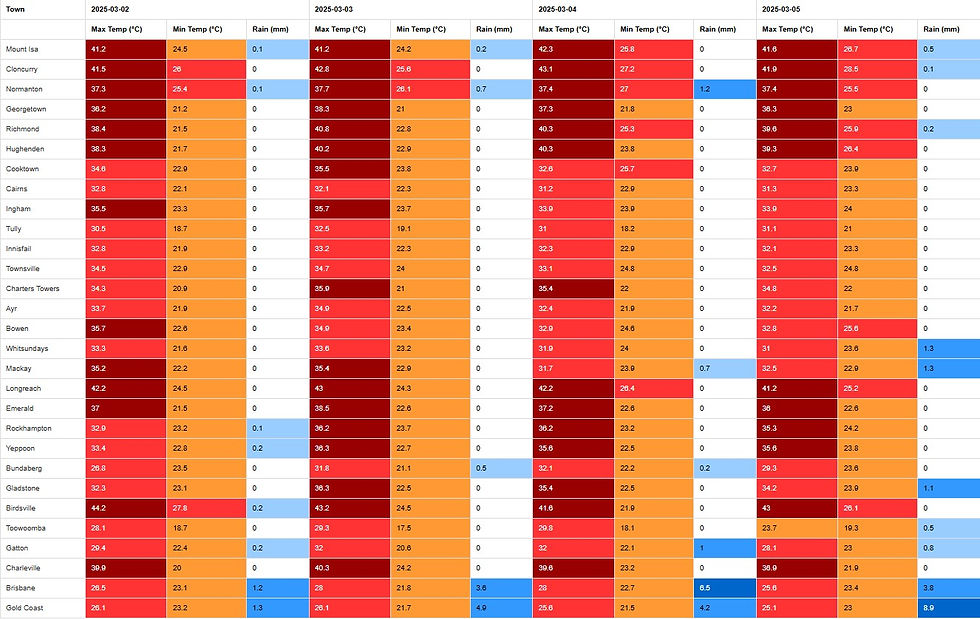
Sunday, 2nd March
Looks like it's going to be a scorcher in the Central Highlands and Coalfields, Central West, and Darling Downs and Granite Belt districts. Time to break out the sunscreen and maybe invest in a portable fan or two.
Monday, 3rd March
Looks like southeast Queensland is in for some scattered showers, while the exposed coast and K'gari can expect a good soaking. Don't forget your umbrella if you're heading that way. Meanwhile, the Gulf Country coast and Torres Strait might see some thunderstorms to liven things up a bit. Everywhere else, it's mostly sunny - a perfect excuse to break out those sunglasses. If you're on the southeast east coast, hold onto your hats - those south to southeasterly winds are no joke. K'gari might have a bit of a windy day, but at least the damaging wind risk is easing. As for temperatures, it's business as usual in the southeast, but things are heating up along the east coast and beyond. In fact, the northern interior is in for a severe heatwave, with some areas even reaching extreme temperatures. Stay cool, folks!
Tuesday, 4th March
Grab your umbrellas, folks! Central and southern Queensland south of Rockhampton and east of Augathella can expect a mix of isolated to scattered showers, with the southeast getting the brunt of it. Don't forget your raincoat if you're heading to the central and northern coasts, where isolated showers are also on the menu. And for those living near the coast of the Gulf of Carpentaria, be prepared for isolated showers and thunderstorms. But fear not, sunshine lovers! The rest of Queensland will be mostly sunny, with temperatures near average in the southeast but soaring well above average in the west and elsewhere. In fact, the northern interior is in for some severe heatwave conditions, with extreme heat expected in the northwest. So grab your sunscreen and stay hydrated, it's going to be a scorcher out there!
Wednesday, 5th March
Well, folks in central and southern Queensland south of Rockhampton and east of Charleville might want to keep an eye out for some showers today. They could be scattered or isolated, depending on your luck. Meanwhile, the southeast is in for a treat with some widespread rain at times - lucky them! If you're living on the remaining coasts or Cape York Peninsula, you might experience some isolated showers. And for those in the northwest and northern Cape York Peninsula, don't be surprised if you hear some thunder rumbling - it's just a few isolated thunderstorms passing by. As for the rest of us, it looks like it'll be partly cloudy. Maximum temperatures will be near or slightly below average in the southeast, but things will be heating up in the west. And if you happen to be in the northern interior or northwest, get ready for some severe heatwave conditions - sunscreen and ice packs at the ready!
Region Round-up - BOM
Forecast for North Tropical Coast and Tablelands:
Well, looks like we've hit the jackpot with clear skies and gentle breezes today. So, if you were planning on flying a kite or having a picnic, today's your lucky day. Just make sure to hold onto your hat, as Mother Nature seems to have taken a break from her usual windy antics.
Location | Icon | Min Temp (°C) | Max Temp (°C) | Description |
Cairns | ☀️ | 21 | 33 | Sunny. |
Atherton | ☀️ | 16 | 31 | Sunny. |
Cooktown | ☀️ | 22 | 34 | Sunny. |
Innisfail | ☀️ | 21 | 33 | Sunny. |
Mareeba | ☀️ | 18 | 35 | Sunny. |
Forecast for Herbert and Lower Burdekin:
Well, it appears that the winds will be doing their little dance at 15 to 20 km/h from the southeast, only to tire out and become light by the evening. So, if you were planning on flying a kite, you might want to schedule that for the morning. Just a friendly tip from your local meteorologist.
Location | Icon | Min Temp (°C) | Max Temp (°C) | Description |
Townsville | ☀️ | 23 | 34 | Sunny. |
Ayr | ☀️ | 21 | 36 | Sunny. |
Ingham | ☀️ | 19 | 35 | Sunny. |
Forecast for Central Coast and Whitsundays:
Looks like the winds are going to be taking a little stroll from the south to the southeasterly direction today, at a leisurely pace of 15 to 20 km/h. They'll eventually tire themselves out and become light by the evening, probably in need of a rest after all that blowing about.
Location | Icon | Min Temp (°C) | Max Temp (°C) | Description |
Mackay | ☀️ | 22 | 32 | Sunny. |
Bowen | ☀️ | 22 | 33 | Sunny. |
Forecast for Peninsula:
Grab your umbrellas, folks! (Just kidding, you won't need them). Today's forecast calls for mostly clear skies with a slight chance of a shower near the west coast. But don't worry, the chances of rain anywhere else are so low, you might as well forget your umbrella at home. Light winds will be blowing through, so hold onto your hats (if you're feeling adventurous).
Location | Icon | Min Temp (°C) | Max Temp (°C) | Description |
Weipa | ⛅ | 23 | 34 | Partly cloudy. |
Coen | ⛅ | 23 | 35 | Mostly sunny. |
Palmerville | ☀️ | 22 | 35 | Sunny. |
Thursday Island | 🌧 | 25 | 31 | Possible shower. |
Forecast for Gulf Country:
Looks like the winds will be doing their little dance from the northeast to southeasterly today, reaching speeds of 15 to 25 km/h before deciding to take a break in the evening. So, if you were planning on flying a kite, you might want to wait until the winds are feeling a bit more cooperative.
Location | Icon | Min Temp (°C) | Max Temp (°C) | Description |
Normanton | ☀️ | 25 | 38 | Sunny. |
Burketown | ☀️ | 24 | 38 | Sunny. |
Doomadgee | ☀️ | 24 | 39 | Sunny. |
Kowanyama | ☀️ | 24 | 35 | Sunny. |
Forecast for Northern Goldfields and Upper Flinders:
Well, it looks like Mother Nature has decided to turn down the fan tonight. Winds will start off southeasterly at a breezy 15 to 25 km/h, but don't worry, they'll be taking a break and becoming light in the evening. Time to break out the wind chimes and enjoy a calm evening, folks!
Location | Icon | Min Temp (°C) | Max Temp (°C) | Description |
Charters Towers | ☀️ | 19 | 37 | Sunny. |
Georgetown | ☀️ | 20 | 38 | Sunny. |
Forecast for Capricornia:
Looks like we might get a sprinkle near the coast, but don't hold your breath for rain anywhere else. Winds will be blowing from the southeast at a brisk 20 to 30 km/h. So, if you're planning on going for a stroll, maybe bring an umbrella just in case - or just hope for the best and enjoy the sunshine while it lasts.
Location | Icon | Min Temp (°C) | Max Temp (°C) | Description |
Gladstone | ⛅ | 24 | 32 | Partly cloudy. |
Rockhampton | ⛅ | 24 | 35 | Partly cloudy. |
Biloela | ⛅ | 21 | 34 | Partly cloudy. |
Yeppoon | ⛅ | 25 | 32 | Partly cloudy. |
Forecast for Central Highlands and Coalfields:
Expect clear skies today with winds coming from the east to southeasterly direction at a moderate 15 to 25 km/h. So hold onto your hats, or they might just blow away!
Location | Icon | Min Temp (°C) | Max Temp (°C) | Description |
Emerald | ☀️ | 22 | 37 | Sunny. |
Clermont | ☀️ | 21 | 37 | Sunny. |
Moranbah | ☀️ | 21 | 36 | Sunny. |
Forecast for Central West:
Looks like it's going to be mostly clear today, with winds coming from the southeast at a brisk 15 to 25 km/h. By the evening, those winds will take a breather and become as light as a feather. So hold onto your hats, or don't, because they might just blow away!
Location | Icon | Min Temp (°C) | Max Temp (°C) | Description |
Longreach | ☀️ | 24 | 41 | Sunny. |
Barcaldine | ☀️ | 23 | 41 | Sunny. |
Winton | ☀️ | 23 | 42 | Sunny. |
Forecast for North West:
The skies are looking crystal clear today, with winds coming in from the east to southeasterly direction at a leisurely 15 to 25 km/h. By the evening, these breezes will be taking a well-deserved rest and becoming as light as a feather. So, grab your windsocks and enjoy the gentle gusts while they last!
Location | Icon | Min Temp (°C) | Max Temp (°C) | Description |
Mount Isa | ☀️ | 23 | 43 | Sunny. |
Forecast for Channel Country:
Grab your umbrella and prepare for some shocking weather near the New South Wales border. Expect mostly clear skies with a slight chance of a thunderstorm. Winds will be coming from the southeast at a leisurely 15 to 20 km/h. Remember, it's always good to be prepared for a little surprise from the skies!
Location | Icon | Min Temp (°C) | Max Temp (°C) | Description |
Birdsville | ☀️ | 29 | 45 | Sunny. |
Thargomindah | ⛅ | 30 | 43 | Partly cloudy. |
Forecast for Maranoa and Warrego:
Well, it appears that the winds will be blowing from the southeast today at a moderate speed of 15 to 25 km/h. So, you might want to hold onto your hat or make sure your hair is securely tied back to avoid any unexpected hairdos. Stay safe out there!
Location | Icon | Min Temp (°C) | Max Temp (°C) | Description |
Charleville | ☀️ | 23 | 40 | Sunny. |
Roma | ☀️ | 20 | 37 | Sunny. |
St George | ☀️ | 21 | 37 | Sunny. |
Cunnamulla | ⛅ | 25 | 41 | Partly cloudy. |
Forecast for Darling Downs and Granite Belt:
Well, it looks like we'll be experiencing some gentle easterly breezes today, nothing too wild. So, make sure your outdoor furniture is securely fastened down to avoid any unexpected redecorating of your yard. Stay safe out there!
Location | Icon | Min Temp (°C) | Max Temp (°C) | Description |
Dalby | ⛅ | 18 | 33 | Mostly sunny. |
Goondiwindi | ☀️ | 19 | 38 | Sunny. |
Toowoomba | ⛅ | 17 | 29 | Partly cloudy. |
Warwick | ⛅ | 16 | 32 | Mostly sunny. |
Stanthorpe | ⛅ | 16 | 27 | Mostly sunny. |
Forecast for Wide Bay and Burnett:
You might want to bring an umbrella if you plan on hitting the coast today. There's a good chance of showers there, and a slight chance elsewhere. The southeasterly winds will be blowing at a brisk 20 to 30 km/h. And if you were thinking of rock fishing, swimming, or surfing, you might want to reconsider. The surf conditions are expected to be large and powerful, making coastal activities a bit hazardous. Stay safe out there, folks!
Location | Icon | Min Temp (°C) | Max Temp (°C) | Description |
Bundaberg | 🌧 | 22 | 29 | Showers. |
Gympie | 🌧 | 22 | 28 | Showers. |
Hervey Bay | 🌧 | 22 | 28 | Rain. Windy. |
Kingaroy | ☁️ | 18 | 28 | Cloudy. |
Maryborough | 🌧 | 22 | 27 | Showers. |
Gayndah | ☁️ | 21 | 32 | Cloudy. |
Forecast for Southeast Coast:
Don't forget your raincoat if you're up north today - there's a slight chance you'll get caught in a shower. But if you're anywhere else, you might as well leave the umbrella at home because the chances of rain are about as likely as finding a unicorn. Just be aware of those southeasterly winds blowing at a moderate speed of 15 to 25 km/h - it's not quite tornado weather, but you might want to hold onto your hat. And if you were planning on hitting the beach, you might want to rethink your strategy. The surf is going to be as large and powerful as a teenager's appetite, so it's probably best to stick to the sandcastles and leave the surfing to the pros. Oh, and if you were thinking of doing some rock fishing or taking a dip in the ocean, you might want to reconsider - those hazardous conditions are no joke. Stay safe out there, folks!
Location | Icon | Min Temp (°C) | Max Temp (°C) | Description |
Beaudesert | ⛅ | 18 | 32 | Partly cloudy. |
Brisbane | 🌧 | 22 | 30 | Shower or two. |
Gatton | ⛅ | 19 | 33 | Partly cloudy. |
Ipswich | ⛅ | 19 | 32 | Partly cloudy. |
Logan Central | 🌧 | 20 | 30 | Shower or two. |
Maroochydore | 🌧 | 23 | 28 | Showers. |
Redcliffe | 🌧 | 23 | 29 | Shower or two. |
Surfers Paradise | 🌧 | 21 | 29 | Shower or two. |
We run on positivity and our output is education for your peace of mind. Wally also runs on coffee so shout him a coffee today, just for for $5 each year, or one each month for a year for $55 https://wallysweather.com.au/community
National maps by Weatherzone (weatherzone.com.au)
State maps by Windy (Windy.com)
Weather forecast supplemented by Bureau of Meteorology (bom.gov.au)
Rainfall daily totals (https://meteologix.com/ )
AccuWeather (https://www.accuweather.com/)
Nine Weather (https://www.9news.com.au/weather)
Wally's Weather provides professionally researched data and information. Andrew aka 'Wally' has over 20 years of experience in meteorology research and data analysis. In 2023 finished top 4 for the AMOS national weather forecasting competition. The content here is provided as educational information aimed at providing the community and businesses with the tools required to determine local-based forecasts. IMPORTANT: The forecasts and information posted should never be used on their own to make business decisions as local influences.


Comments