Energised Daily Forecast - Feb 7 - Wally's Weather Australia
- Feb 6, 2025
- 17 min read
We're thrilled to welcome Genesis Industries, returning for another wet season as our Daily Forecast primary sponsor!

.
Thanks Genesis! 🙏
🔋 𝗗𝗼𝗻’𝘁 𝗕𝗲 𝗟𝗲𝗳𝘁 𝗜𝗻 𝗧𝗵𝗲 𝗗𝗮𝗿𝗸! 🌧️
𝑮𝑬𝑵𝑬𝑹𝑨𝑻𝑶𝑹 𝑰𝑵𝑳𝑬𝑻𝑺 🔌, 𝑼𝑷𝑺 🔋, 𝒐𝒓 𝑩𝑨𝑻𝑻𝑬𝑹𝒀 𝑩𝑨𝑪𝑲𝑼𝑷 🔋 𝑺𝒑𝒆𝒄𝒊𝒂𝒍!
Be prepared this wet season with reliable power backup solutions from Genesis Industries! Whether you need GENERATOR INLETS 🔌, UPS 🔋, or BATTERY BACKUP 🔋 systems, we’ve got you covered! 🏠💡
Just mention “𝙒𝙖𝙡𝙡𝙮’𝙨 𝙒𝙚𝙖𝙩𝙝𝙚𝙧” for a 𝟭𝟬% 𝗗𝗜𝗦𝗖𝗢𝗨𝗡𝗧 and ensure your power stays on, no matter the storm! ⛈️⚡
Don’t wait – secure your peace of mind today with Genesis Industries! 🛠️✔️
📞 Call 1300 4 GENESIS (1300 443 637) and experience top-notch service that’s shockingly good ⚡, refreshingly cool ❄️, and perfectly on tap 🚿!
𝟭𝟯𝟬𝟬 𝟰 𝗚𝗘𝗡𝗘𝗦𝗜𝗦 (𝟭𝟯𝟬𝟬 𝟰𝟰𝟯 𝟲𝟯𝟳)
National Synoptic Situation
National Temperature and Rainfall

Rain typically refers to steady, continuous precipitation that lasts for a longer period, sometimes hours or even days. It can vary in intensity, but it's usually more consistent and widespread.
Showers, on the other hand, are shorter bursts of rain, often intermittent. They can be heavy but usually don't last long. Showers are more sporadic and may be followed by dry periods or other types of weather, like sun or clouds.
State conditions
QLD:
Well, it seems like we've got quite the weather situation brewing up in northern Queensland. The monsoon trough is stretching its legs across Cape York Peninsula and doesn't seem to be in any rush to leave. There's talk of a potential tropical low forming near the northeast tropical coast, so be sure to keep an eye out for any stormy developments. Meanwhile, a weak ridge is hanging out over the east coast, just minding its own business. But don't let its laid-back attitude fool you, as it's expected to strengthen early next week. And let's not forget about the trough that might be making its way over the southeast of the state as well. With all this talk of storms and heatwaves, it's important to stay safe out there. Make sure you're prepared for any weather surprises that may come your way. And remember, when in doubt, it's always better to be safe than sorry. So buckle up and ride out this weather rollercoaster with caution!
NSW and ACT:
Well, brace yourselves, folks, because it looks like we're in for a rollercoaster of weather patterns. A high pressure system is currently lounging over the Tasman Sea, sending a ridge our way in northeastern New South Wales. Meanwhile, a coastal trough is putting on its disappearing act over the Mid-North Coast before a second trough decides to crash the party from the far west. This second trough is bringing along some friends - widespread showers and thunderstorms. So, if you happen to be out and about on Friday, don't forget your umbrella and rubber ducky. But wait, there's more! By Sunday, this second system will have made its way over to the northeast, but don't worry, it'll be too tired to cause too much trouble by then. Just remember, when it comes to storms and heatwaves, it's always better to be safe than sorry. So, stay indoors, stay hydrated, and stay safe out there, my friends.
VIC:
Well, it seems like we've got a little drama unfolding in the skies above. A low pressure trough is making its way from the north, causing quite a stir. It's expected to deepen overnight and then saunter over to the east of the State by Friday. Meanwhile, a high pressure system is getting cozy down south near the bight. It's planning to meander eastward over the weekend, eventually settling in the Tasman sea by Monday. Now, before you start dreaming of sunny skies and gentle breezes, let's not forget to mention the possibility of storms and heatwaves. It's important to stay safe and keep an eye on any weather warnings that may come your way. After all, it's better to be prepared than caught in the middle of a storm without an umbrella. Stay safe out there, friends!
SA:
Well, brace yourselves for some wild weather coming your way! A low pressure trough hanging out in the northeast of SA is just chillin' and not going anywhere fast. Meanwhile, a high pressure system is making its way across the waters south of WA, followed by a low pressure trough creeping in from the west next week. With all these weather systems doing their thing, there's a good chance we'll be experiencing some storms or heatwaves. So, remember to stay safe and prepared for whatever Mother Nature decides to throw at us!
WA:
Hold onto your hats, folks, it looks like Mother Nature is feeling a bit moody up in northern WA. A low pressure trough is just hanging out up there, possibly inviting a weak low pressure centre to join the party over the Kimberley this weekend. So, stay safe out there and make sure to keep an eye on the forecast for any potential storms or heatwaves heading your way.
TAS:
Hold onto your hats, because it looks like Tasmania is in for a wild ride this weekend! A high pressure system over the Tasman Sea is throwing a ridge our way, followed by a cold front from the southwest on Thursday. This front will be crossing the state on Friday, bringing with it some stormy weather. But wait, there's more! A high building in the Bight on Friday will be ridging out over Tasmania on Saturday, and then passing to the south of the state on Sunday and Monday. So, buckle up and stay safe out there, folks! It's going to be a bumpy ride with potential storms and heatwaves headed our way.
NT:
Keep an eye out for a feeble low lazily meandering over the Gregory District, making its way towards the Kimberley. Meanwhile, a trough will be hanging around the Gregory and northern Barkly Districts, taking its sweet time to move on. The monsoon will start flexing its muscles, bringing showers and rain to the Top End and Carpentaria District over the weekend. Down south, a ridge will keep things toasty with those relentless easterly winds. So, buckle up and stay safe out there as these weather shenanigans unfold. Storms and heatwaves are on the horizon, so make sure you have your sunblock and umbrellas handy. Don't let Mother Nature catch you off guard!
National Weather Warnings
New South Wales
Victoria
Queensland
06/10:03 EST Major Flood Warning for the Murray River and Moderate Flood Warning for the Tully River
Western Australia
South Australia
Tasmania
Northern Territory
National Storms and Rain Accumulation outlook


Four Day Forecasts
If you run a business and would like the benefits of a Big Shout plus your business promoted for 365 days, head here to take out a Bold Shout for $250.


NQ Rainfall 24 Accumulated (ACCESS G)


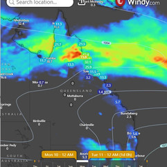
The trough can be seen extending out into the Coral Sea and for Sunday and Monday we could see the return of heavy rain systems where the trough cuts the coastline and warm humid air meets cool dry air from the South. The good news looking ahead (at this stage) there is a small break after that. But that pesky low could be returning to QLD.
Temperature and Rainfall Forecast - Access-G

Friday, 7th February
Prepare yourself for a mixed bag of weather today, with a chance of showers and thunderstorms in some areas. Keep an eye out for scattered showers and possible heavy rainfall up north. Don't forget your umbrella! Stay safe out there, folks, as the winds shift from northwest to southeasterly throughout the state. Temperatures will vary, with some areas experiencing below average highs while others may feel slightly warmer than usual. Remember to stay hydrated and seek shelter if any storms roll through. In conclusion, keep an eye on the skies and be prepared for whatever Mother Nature throws your way. Stay safe and enjoy the unpredictable weather!
Saturday, 8th February
Oh dear, it seems like Mother Nature has quite the mood swings planned for us. Expect some scattered showers here and there, with a chance of thunderstorms up north. Don't be surprised if you find yourself caught in some heavy rainfall, especially along the northeast tropical coast. Down south, there might be a few isolated thunderstorms to keep things interesting. And as if that wasn't enough, temperatures will be all over the place. It'll be cooler than usual up north, but down south, things will be slightly warmer. So, make sure you're prepared for whatever comes your way - whether it's storms or heatwaves. Stay safe out there, folks!
Sunday, 9th February
Grab your umbrella and sunscreen, Queensland! We've got a mix of showers, thunderstorms, and below-average temperatures coming our way. Keep an eye out for heavy rainfall in certain areas, and be prepared for some surprises from Mother Nature. Stay safe out there!
Monday, 10th February
Prepare for some scattered showers and possible thunderstorms in the north of Townsville, with heavy rainfall a possibility. In the southeast, expect isolated showers that could turn into scattered ones. Temperatures will be below average in central and northern Queensland, but above average in the southern interior. Stay safe and dry out there!
Region Round-up - BOM
North Tropical Coast and Tablelands
Region Forecast: Looks like we're in for a real treat today - cloudy skies and a high chance of rain, with a side of thunderstorms to keep things interesting. Don't be surprised if you get caught in a downpour or two, and hold on to your hats in case those winds pick up. Temperatures will be dropping to a balmy 20 to 25 degrees overnight, but don't get too comfortable - we'll be heating things up again during the day, with highs reaching 25 to 33 degrees. It's like a rollercoaster of weather patterns out there! Remember to stay safe during any storms or heatwaves, folks. Make sure you have your umbrella handy and stay hydrated to beat the heat. Mother Nature can be quite the prankster, so it's best to be prepared for whatever she throws our way.
Location | Icon | Min Temp (°C) | Max Temp (°C) | Description |
Cairns | 🌧 | 25 | 31 | Rain. Possible storm. |
Atherton | 🌧 | 21 | 26 | Rain. Possible storm. |
Cooktown | 🌧 | 24 | 33 | Showers. Possible storm. |
Innisfail | 🌧 | 24 | 28 | Rain. Possible storm. |
Mareeba | 🌧 | 23 | 29 | Rain. Possible storm. |
Herbert and Lower Burdekin
Region Forecast: Well, looks like Mother Nature is feeling a bit moody today. We've got some stormy weather on the horizon, so make sure to pack your umbrella and waterproof boots. There's a very high chance of rain, with the possibility of a severe thunderstorm. Heavy rain might even lead to flash flooding, so stay safe and avoid any potentially dangerous areas. Don't be fooled by the light winds in the early afternoon, as they'll pick up to a breezy easterly 15 to 20 km/h. By late afternoon, they'll calm down, giving us a chance to dry off from the rain. Overnight temperatures will drop to the low to mid 20s, so keep a light blanket handy. Daytime temperatures will reach the mid to high 20s, so you might want to break out those summer clothes. In conclusion, it's shaping up to be an eventful day weather-wise. Remember to stay safe during any storms or heatwaves, and always be prepared for whatever Mother Nature throws our way.
Location | Icon | Min Temp (°C) | Max Temp (°C) | Description |
Townsville | 🌧 | 24 | 27 | Rain. Possible storm. |
Ayr | 🌧 | 23 | 25 | Rain. |
Ingham | 🌧 | 24 | 27 | Rain. Possible storm. |
Central Coast and Whitsundays
Region Forecast: Looks like Mother Nature is feeling a bit moody today, with a high chance of rain and the possibility of a thunderstorm thrown into the mix. Don't be surprised if heavy falls make an appearance, especially inland. The winds will be doing their little dance from east to southeasterly at a leisurely 15 to 20 km/h, before deciding to pick up the pace in the morning. As the night falls, temperatures will dip down to the low 20s, giving us a break from the heat. Daytime temperatures will be hanging around the low to mid 20s, so it's not exactly a heatwave, but still warm enough to make you consider wearing shorts. Stay safe out there and make sure to have your umbrellas at the ready!
Location | Icon | Min Temp (°C) | Max Temp (°C) | Description |
Mackay | 🌧 | 22 | 25 | Rain. |
Bowen | 🌧 | 23 | 26 | Rain. |
Peninsula
Region Forecast: Well, buckle up folks, looks like we might have some stormy weather coming our way. There's a high chance of showers, especially in the late morning and afternoon. And hold onto your hats, there's even a chance of a thunderstorm with possible heavy falls south of Palmerville. Don't be fooled by the light winds in the morning, they'll be picking up speed to a north to northwesterly 15 to 25 km/h. So hold onto your umbrellas, or better yet, just stay indoors and avoid getting caught in the storm. Overnight temperatures won't bring much relief, falling only to the mid 20s. Daytime temperatures, on the other hand, will be reaching the low to mid 30s. So make sure to stay hydrated and find some shade to avoid the heatwave. Remember, safety first folks! Stay safe and dry out there.
Location | Icon | Min Temp (°C) | Max Temp (°C) | Description |
Weipa | 🌧 | 25 | 32 | Showers. Possible storm. |
Coen | 🌧 | 26 | 33 | Showers. Possible storm. |
Palmerville | 🌧 | 24 | 31 | Showers. Possible storm. |
Thursday Island | 🌧 | 26 | 31 | Shower or two. |
Gulf Country
Region Forecast: Looks like Mother Nature is feeling a bit moody today, with a high chance of rain and even a thunderstorm thrown into the mix. Down in the south, we might even see some heavy falls - so hold onto your hats! Winds will be coming from the northeast at 15 to 20 km/h, switching to a slightly more dramatic northerly direction at 15 to 25 km/h in the morning. By evening, things will calm down a bit with light winds. Overnight, temperatures will drop to the mid 20s, but during the day, it's going to be a scorcher with temperatures ranging from 27 to 32 degrees. So, if you find yourself caught in a storm or heatwave, remember to stay safe and take precautions. Mother Nature might be unpredictable, but that doesn't mean we can't be prepared!
Location | Icon | Min Temp (°C) | Max Temp (°C) | Description |
Normanton | 🌧 | 25 | 29 | Rain. Possible storm. |
Burketown | 🌧 | 24 | 32 | Rain. Possible storm. |
Doomadgee | 🌧 | 24 | 32 | Showers. Possible storm. |
Kowanyama | 🌧 | 25 | 32 | Rain. Possible storm. |
Northern Goldfields and Upper Flinders
Region Forecast: Looks like we're in for some wet and wild weather! There's a very high chance of rain, so you might want to grab your umbrella (or just stay indoors, if you're feeling lazy). There's even a chance of a thunderstorm, which could be severe with heavy rain - so definitely don't forget to bring a boat along just in case of flash flooding in the south. The winds will be light at first, but they'll pick up throughout the day, so hold onto your hats (or just let them fly away, if you're feeling adventurous). Temperatures will be dropping overnight, but it'll still be pretty warm, so make sure to stay hydrated (or just take a nap in the fridge, if you're feeling overheated). Stay safe out there, folks! And remember, when it rains, it pours - both literally and metaphorically.
Location | Icon | Min Temp (°C) | Max Temp (°C) | Description |
Charters Towers | 🌧 | 23 | 26 | Rain, possible storm. Heavy falls. |
Georgetown | 🌧 | 23 | 26 | Rain, possible storm. Heavy falls. |
Capricornia
Region Forecast: Looks like Mother Nature is feeling a bit moody today, with a chance of showers up north and a slight chance elsewhere. Light winds will be doing their thing, starting off in the southeast and then heading over to the east. Temperatures will be dropping overnight to a somewhat cool 19 to 22 degrees, but don't get too comfortable because it's going to heat up during the day, reaching a scorching 27 to 33 degrees. So make sure to stay safe out there, folks, and keep an eye out for any storms or heatwaves heading your way!
Location | Icon | Min Temp (°C) | Max Temp (°C) | Description |
Gladstone | 🌧 | 23 | 31 | Possible shower. |
Rockhampton | 🌧 | 23 | 29 | Shower or two. |
Biloela | ⛅ | 19 | 34 | Partly cloudy. |
Yeppoon | 🌧 | 24 | 28 | Shower or two. |
Central Highlands and Coalfields
Region Forecast: Get your umbrellas ready, folks! It seems like there's a high chance of rain up north, with just a slight chance of showers elsewhere. And watch out for those thunderstorms, especially in the north - heavy falls could be on the way! Don't be fooled by the light winds in the morning, they'll pick up to a breezy easterly 15 to 20 km/h before calming down in the evening. Overnight temperatures will drop to a cool 18 to 21 degrees, but during the day, things are heating up with temperatures reaching a scorching 22 to 33 degrees. So, stay safe out there, especially if you're in the path of those storms. And don't forget to stay hydrated in this sweltering heatwave!
Location | Icon | Min Temp (°C) | Max Temp (°C) | Description |
Emerald | 🌧 | 20 | 29 | Shower or two. |
Clermont | 🌧 | 19 | 26 | Rain. |
Moranbah | 🌧 | 20 | 22 | Rain. |
Central West
Region Forecast: Looks like Mother Nature is feeling a bit moody up north of Longreach, with a very high chance of rain and thunderstorms on the horizon. Better grab your umbrella and rubber boots, folks! Don't be surprised if heavy falls come crashing down from the sky. Meanwhile, further south, there's a medium chance of rain so you might want to keep that raincoat handy. The easterly winds are picking up speed at 20 to 30 km/h, adding a bit of drama to the weather forecast. With overnight temperatures dropping to around 20 degrees, it's going to be a bit chilly. But don't let that fool you - daytime temperatures will still reach a balmy 23 to 30 degrees. So be prepared for some heatwave action as well. Stay safe out there, folks, and remember to keep an eye on the weather warnings. Mother Nature can be quite unpredictable, so it's always best to be prepared for whatever she throws our way.
Location | Icon | Min Temp (°C) | Max Temp (°C) | Description |
Longreach | 🌧 | 21 | 29 | Shower or two. |
Barcaldine | 🌧 | 21 | 27 | Rain at times. |
Winton | 🌧 | 21 | 26 | Rain, possible storm. Heavy falls. |
North West
Region Forecast: Looks like the skies are feeling a bit moody today, with a high likelihood of rain and even a thunderstorm making an appearance. Get ready for some heavy falls, folks! The winds will be light at first, but then they'll pick up to a northeasterly direction before shifting to an easterly direction later in the day. Overnight, temperatures will drop to the low to mid 20s, so be sure to stay cozy and safe indoors. During the day, temperatures will range from 26 to 31 degrees, so make sure to stay hydrated and cool during this potential stormy weather. Remember, it's always better to be safe than sorry when it comes to dealing with Mother Nature's mood swings!
Location | Icon | Min Temp (°C) | Max Temp (°C) | Description |
Mount Isa | 🌧 | 22 | 29 | Rain, possible storm. Heavy falls. |
Channel Country
Region Forecast: Prepare yourselves for a rollercoaster of weather today, with a sprinkle of showers up north and a dash of thunderstorms near the Northern Territory border. Keep an eye out for possible severe storms and heavy rainfall - it's all part of the fun! Don't forget your sunscreen and stay hydrated as temperatures soar to the high 30s. Stay safe out there, folks!
Location | Icon | Min Temp (°C) | Max Temp (°C) | Description |
Birdsville | ☀️ | 26 | 40 | Sunny. |
Thargomindah | ⛅ | 25 | 38 | Partly cloudy. |
Maranoa and Warrego
Region Forecast: Ah, looks like we've got a mixed bag of weather coming our way. There's a slight chance of a shower in the late morning and afternoon, along with the possibility of a thunderstorm. Winds will be northeasterly, then easterly, and finally becoming light in the evening. Overnight temperatures will drop to between 18 and 23 degrees, while daytime temperatures will soar to 31 to 37 degrees. So, make sure to stay safe and hydrated during this heatwave and keep an eye out for any potential storms. Mother Nature can be quite unpredictable, after all.
Location | Icon | Min Temp (°C) | Max Temp (°C) | Description |
Charleville | ⛅ | 20 | 33 | Partly cloudy. |
Roma | ⛅ | 20 | 34 | Partly cloudy. |
St George | ⛅ | 21 | 34 | Mostly sunny. |
Cunnamulla | ⛅ | 22 | 36 | Partly cloudy. |
Darling Downs and Granite Belt
Region Forecast: Prepare to bask in the glory of the sun, with a slight chance of a shower for those lucky enough to be in the far east. Don't worry, the rest of us will be left high and dry with near zero chance of rain. Winds will be dancing around from east to northeasterly, adding a touch of whimsy to your day. Just remember to stay cool in the heat, with daytime temperatures reaching a scorching 31 to 36 degrees. Overnight, temperatures will mercifully drop to between 17 and 21 degrees, providing a brief respite from the fiery wrath of the sun. Stay safe out there, folks!
Location | Icon | Min Temp (°C) | Max Temp (°C) | Description |
Dalby | ⛅ | 18 | 32 | Mostly sunny. |
Goondiwindi | ⛅ | 21 | 35 | Mostly sunny. |
Toowoomba | ⛅ | 18 | 28 | Partly cloudy. |
Warwick | ⛅ | 17 | 31 | Partly cloudy. |
Stanthorpe | ⛅ | 17 | 27 | Partly cloudy. |
Wide Bay and Burnett
Region Forecast: Beware, fellow Earthlings! There is a slight possibility of showers hovering over our heads, particularly during the late morning and afternoon. The winds are expected to play a game of musical chairs, starting off light and then switching to an east to southeasterly direction at speeds of 15 to 25 km/h. By evening, they'll be tired out and decide to take a nap. As the night creeps in, temperatures will drop to a chilly 17 to 21 degrees, so make sure to dig out those extra blankets. Meanwhile, during the day, prepare for the mercury to soar around 30 degrees, turning our surroundings into a veritable sauna. Remember, my friends, when the storms roll in or the heatwaves strike, safety should always be our number one priority. Stay cool, stay dry, and most importantly, stay safe!
Location | Icon | Min Temp (°C) | Max Temp (°C) | Description |
Bundaberg | 🌧 | 21 | 30 | Possible shower. |
Gympie | 🌧 | 20 | 29 | Possible shower. |
Hervey Bay | ⛅ | 22 | 30 | Partly cloudy. |
Kingaroy | 🌧 | 17 | 29 | Possible shower. |
Maryborough | 🌧 | 20 | 30 | Possible shower. |
Gayndah | ⛅ | 19 | 31 | Partly cloudy. |
Southeast Coast
Region Forecast: Looks like we've got a classic case of partly cloudy skies with a side of showers - perfect for those who enjoy a little sprinkle here and there. Winds will be making a guest appearance from the south to southeasterly direction, giving us a gentle breeze of 15 to 20 km/h. Don't worry, they'll switch things up to east to southeasterly in the middle of the day and then take a break in the late evening. As for temperatures, overnight will be a cool 17 to 21 degrees, giving us a chance to snuggle up in bed. But don't get too comfortable, as daytime temperatures will soar to a toasty 30 degrees. It's like a rollercoaster ride of weather, keeping us on our toes! Remember to stay safe and be prepared for any unexpected storms or heatwaves that may come our way. And as always, enjoy the unpredictable nature of our dear friend, the weather.
Location | Icon | Min Temp (°C) | Max Temp (°C) | Description |
Beaudesert | 🌧 | 19 | 31 | Shower or two. |
Brisbane | 🌧 | 21 | 30 | Possible shower. |
Gatton | ⛅ | 20 | 31 | Partly cloudy. |
Ipswich | 🌧 | 20 | 32 | Possible shower. |
Logan Central | 🌧 | 20 | 30 | Possible shower. |
Maroochydore | 🌧 | 21 | 29 | Shower or two. |
Redcliffe | 🌧 | 22 | 29 | Shower or two. |
Surfers Paradise | 🌧 | 20 | 29 | Shower or two. |
We run on positivity and our output is education for your peace of mind. Wally also runs on coffee so shout him a coffee today, just for for $5 each year, or one each month for a year for $55 https://wallysweather.com.au/community
National maps by Weatherzone (weatherzone.com.au)
State maps by Windy (Windy.com)
Weather forecast supplemented by Bureau of Meteorology (bom.gov.au)
Rainfall daily totals (https://meteologix.com/ )
AccuWeather (https://www.accuweather.com/)
Nine Weather (https://www.9news.com.au/weather)
Wally's Weather provides professionally researched data and information. Andrew aka 'Wally' has over 20 years of experience in meteorology research and data analysis. In 2023 finished top 4 for the AMOS national weather forecasting competition. The content here is provided as educational information aimed at providing the community and businesses with the tools required to determine local-based forecasts. IMPORTANT: The forecasts and information posted should never be used on their own to make business decisions as local influences.


Comments