Daily Forecast - August 31 - Wally's Weather Australia
- Aug 30, 2024
- 9 min read
Updated: Aug 31, 2024
To get your daily forecast delivered free goto http://wallysweather.com.au/blog

Welcome Garry Thyer's Betta
Hyde Park Centre
Our prime daily forecast sponsors for August to October inclusive.
Address: Shop 8, Hyde Park Centre, Woolcock St, Hyde Park QLD 4812
Phone: (07) 4721 1211
National - Warnings - 4 Day - State - Min-Max-Rain - Regional Round-Up
National
Looks like Mother Nature is feeling a bit feisty today, folks! A brisk westerly airflow is causing some gusty showers to be flung over SA, Vic, Tas, and southeast NSW. Don't forget your umbrellas, unless you enjoy a spontaneous shower! And for those of you heading to the Alps or Tasmanian highlands, get ready for some snow - because who doesn't love a surprise snowball fight in May? Meanwhile, in southern Qld and central AUS, it's hotter than a jalapeño in a sauna. Thanks to some hot, dry winds being dragged east by the fronts, it's feeling like summer in places where it should still be feeling like autumn. So grab your sunscreen and a hat


Synoptic | Temp/Rain | Wind | Sea Surface Temp
National Warnings
TAS: Severe Weather Warning (Damaging Winds) for multiple regions.
TAS: Initial Minor Flood Warning for the Forth River.
VIC: Severe Weather Warning (Damaging Winds) for various regions.
VIC: Gale Warning for several coasts. Strong Wind Warning for others.
VIC: Abnormally High Tides and Damaging Surf for several regions.
SA: Gale Warning for multiple coasts.
NSW/ACT: Strong Wind Warning for Sydney Enclosed Waters. Cancellation for several coasts.
QLD: Strong Wind Warning for Sunshine Coast Waters and Gold Coast Waters.
TAS: Gale Warning for multiple coasts.
TAS: Moderate Flood Warning for the Meander River.
NSW/ACT: Final Gale Warning for Southern Area.
NSW/ACT: Storm Force Wind Warning for Southeastern and Southern Areas.
NSW/ACT: Gale Warning for Southern, Southeastern, and Western Areas.
TAS: Abnormally High Tides and Damaging Surf for several regions.
TAS: Minor Flood Warning for the North Esk River.
TAS: Moderate Flood Warning for the Mersey River.
TAS: Minor Flood Warning for the Macquarie River and Flood Warning for other rivers.
TAS: Flood Watch for several rivers.
NSW/ACT: Minor Flood Warning for the Lachlan River.
TAS: Minor Flood Warning for the South Esk River.
WA: Gale Warning for the Esperance Coast. Strong Wind Warning for several coasts.
TAS: Moderate Flood Warning for the River Derwent, Minor Flood Warning for the River Ouse, and Flood Warning for other rivers.
TAS: Minor Flood Warning for the Huon River.
SA: Severe Weather Warning (Damaging Winds) for various districts.
VIC: Cancellation of Sheep Graziers Warning for North East.
TAS: Sheep Graziers Warning for multiple regions. Cancelled Sheep Graziers Warning for the E Coast.
NSW/ACT: Sheep Graziers Warning for Southern Tablelands, Snowy Mountains, and Australian Capital Territory.
SA: Sheep Graziers Warning for Mount Lofty Ranges. Cancellation of Sheep Graziers Warning for Lower South East.


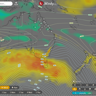


WINDY.COM Extreme Weather
The 4 day forecast brought to you by our local businesses, you could have this spot with your details, support local, take out a Bold Shout ! $250 for a year, you get this and the website every day!


National 4 Day Forecast


Windy.com NEW ACCESS 4 Day Accumulated Rain and Synoptic
Saturday: It's going to be sunnier and warmer than usual in most parts of the state, except for some scattered showers along the east coast north of Ingham. Expect some decent gusts blowing from the west to northwest in the south, and gentle to moderate breezes from the east to southeast in the north. So, basically, grab your sunscreen and hold onto your hats, folks!
Sunday: Most of the state will be basking in sunshine on Sunday, but don't be surprised if you run into a sprinkle or two on the east coast above Townsville. Watch out for some fog in the morning around Cairns to Hervey Bay and possibly near the southern Gulf coast. The temperatures will be unusually high in the interior south of Townsville and in the southeast, while being above average everywhere else. So, be prepared to sweat a little extra in those regions!
Monday: The sun's shining brightly across most of the state, just like a happy camper who forgot their sunscreen. There might be a few random showers on the east coast above Ingham, spreading out like someone trying to share their snacks. Down in southeast Queensland, it's windy enough to make you feel like you're in a hair commercial. The temperatures are cranking up higher than expected in the south, kind of like a desert mirage, with the rest of the areas above average too, as if someone turned up the thermostat statewide.
Tuesday: Most of the state will enjoy some sunshine today, but expect a few clouds and isolated showers on the east coast. Showers will become more scattered along the North Tropical Coast. Watch out for those fresh and gusty southeasterly winds stirring up trouble, especially for fire risks in the interior and western areas. It's a tale of two temperatures—above average in the interior and slightly below average in the southeast and southwest. Stay cool, but not too cool!
State


Windy.com ACCESS (Rainfall at 6 hour points over the next 24 hours, 10pm, 4am, 10am, 4pm)
So, apparently there's this big high northeast of New Zealand that's going to keep a ridge over the eastern part of the state for a while. But hold on to your hats because a trough is sneaking into the far southwest today, making its way across the southern interior over the weekend, and finally reaching the southeast by Monday. Before you start planning your winter wardrobe, know that there will be warm temperatures hanging around, almost breaking records until early next week thanks to some northerly winds. The trough is expected to jet off into the ocean by Tuesday, making room for a new high to take over and bring cooler breezes from the southeast back to eastern Queensland. So get ready for some temperature rollercoaster!
Min - Max - Rain

Regional Round-Up
North Tropical Coast and Tablelands:
Get ready for a day of weather whiplash: Mostly sunny skies with potential fog for a dramatic morning effect, a mere possibility of a shower near the coast, and negligible rain chances elsewhere – perfect for staying dry but on your toes. Winds will start gentle but then switch to a more purposeful east to northeasterly direction at 15 to 25 km/h by morning, adding a touch of whimsy to your day. Temperatures will play a game of hide-and-seek, dropping overnight to a range between 11 and 19 before soaring to 25 to 31 during the day, making for a delightful weather rollercoaster.
Herbert and Lower Burdekin:
Partly cloudy day with potential morning fog, mostly inland proves Mother Nature likes a little hide and seek. There's a small possibility of a coastal shower, but don't hold your umbrella out too long. Light breezes will turn into Northeasterly winds of 15 to 20 km/h midday, only to wind down to a whisper come evening - Mother Nature's version of hitting the snooze button. Overnight brings temperatures cooling down to a range of 12 to 17, giving us a taste of that chilly night life, while daytime highs will soar to a toasty 27 to 32, giving us the ultimate Goldilocks weather - not too hot, not too cold, just right.
Central Coast and Whitsundays:
Expect a mystical morning fog show followed by a dazzling sunny afternoon extravaganza. The winds will play around, changing from light to north to northeasterly at a moderate 15 to 20 km/h pace, then calming down by the late evening. Overnight, temperatures will dip down to a cozy 13-16 degrees, while daytime will be a toasty 27-32 degrees. Keep your umbrella handy for any surprise rain dances by the weather gods.
Peninsula:
Expect a day of mixed conditions - from sunny skies to a dash of showers along the east coast. Rain chances are minimal elsewhere. Winds will play the field, starting light then picking up speed from the east in the morning before dialing down in the evening. Temperatures will dance between 15 and 22 overnight but crank up the heat during the day, hitting 31 to 37 degrees.
Gulf Country:
Sunny with a small potential for fog in the west during the early hours; light breezes will shift from northwest to northeasterly at 15 to 20 km/h in the AM, tapering off by the evening. Temperatures will dip overnight to 16-19°C, while daytime highs will sizzle in the mid to high 30s. No umbrella needed, just sunglasses and sunscreen!
Northern Goldfields and Upper Flinders:
Expect a sunny day with breezy north to northeasterly winds of 15-20 km/h, which will then become light in the middle of the day before picking up again as east to northeasterly at 15-20 km/h in the late afternoon—as if the wind can't make up its mind. Overnight, temperatures will drop to a range of 12-16 degrees, so make sure to grab a cosy blanket. Daytime temperatures will soar between 32-37 degrees, giving you a taste of that sweet summer heat. Keep hydrated and sunscreen handy!
Capricornia:
There's a slight possibility of morning fog causing a mysterious start, but fear not, for a sunny afternoon shall illuminate the day. Light winds will gracefully transition into a more assertive northerly direction, flowing at 15 to 20 km/h in the morning. Prepare for a cool night as temperatures drop to a cosy 12 to 16 degrees, with scorching daytime highs peaking between 28 and 33 degrees, making it a perfect opportunity to plan your activities around this weather rollercoaster.
Central Highlands and Coalfields:
Don't let the morning fog in the northeast dampen your spirits, as the day will bring plenty of sunshine with northerly winds at a leisurely 15 to 20 km/h, eventually shifting to a north to northeasterly direction in the evening. Temperatures will chill out overnight to a cozy 12-15 degrees, but brace yourself for some summer feels with daytime temperatures soaring into the low to mid 30s - perfect for those who like it hot!
Central West:
Tomorrow, expect a sun-soaked day with a touch of whimsy as the winds play hide-and-seek from the north to northeasterly direction. They'll start at 15 to 25 km/h, drop to a whisper in the evening, and then switch back to 15 to 20 km/h later on. Temperatures will cool down to a pleasant 13-17 overnight, but brace yourself for a scorching hot day ahead with highs of 34-39. Bring a parasol and some extra sunscreen – it's going to be a sizzler!
North West:
It's going to be a scorching day in the oven, I mean, weather world! 🌞 Expect light winds in the morning that will give your hair a gentle tousle before deciding to switch things up to a northerly direction at 15 to 20 km/h. Don't worry though, they'll take a chill pill and become light again by midday. 🌬️ Overnight, temperatures wi
ll drop to a range fit for a cozy blanket fort, between 13 and 18 degrees. But when the sun flexes its muscles, be ready to sizzle as daytime temperatures soar into the high 30s! 🔥 Don't forget your sunscreen and stay hydrated, folks! 🕶️🥤
Channel Country:
Tomorrow will be a mixed bag with sunny skies, winds doing the hokey-pokey from north to southwesterly at 15 to 25 km/h, then twirling at 15 to 20 km/h in the evening; expect temperatures to play hide-and-seek, dropping to 15-18°C overnight, then peeking at 31-39°C during the day. Pack both sunglasses and a sweater!
Maranoa and Warrego:
Expect a sunny day ahead with winds starting from the north and shifting to the northwest to southwesterly during midday, before finally deciding to take a break in the evening; overnight temperatures dropping to a cozy 15-18 degrees Celsius, while daytime highs are predicted to soar between 31-37 degrees Celsius – so make sure to pack your sunglasses and sunscreen!
Darling Downs and Granite Belt:
Prepare for a sunny day with breezy winds starting from the north, shifting to the west-northwest and eventually calming down by evening; overnight, expect temperatures to drop to a comfortable range of 14-17°C, while daytime will bring the heat with low to mid 30s, reminding us that summer is still holding on tight.
Wide Bay and Burnett:
Expect a sunny day with breezy north to northwesterly winds calming down later; overnight lows around 13-16°C with daytime highs in the low to mid 30s, so carry your sunscreen and a fan could be your best friend.
Southeast Coast:
Expect hot temperatures during the day with cooler nights, windy conditions starting from the northwest and shifting to the west, and then calming down by the evening, with wind speeds ranging from 15 to 40 km/h. Nighttime temperatures will drop to 15-19°C, while daytime temperatures will peak in the low to mid-30s°C. No rain in sight, just a sunny day ahead!
Click here to support to Wally's Weather
National maps by Weatherzone (weatherzone.com.au)
State maps by Windy (Windy.com)
Weather forecast supplemented by Bureau of Meteorology (bom.gov.au)
Rainfall daily totals (https://meteologix.com/ )
AccuWeather (https://www.accuweather.com/)
Nine Weather (https://www.9news.com.au/weather)
Wally's Weather provides professionally researched data and information. Andrew aka 'Wally' has over 20 years of experience in meteorology research and data analysis. In 2023 finished top 4 for the AMOS national weather forecasting competition. The content here is provided as educational information aimed at providing the community and businesses with the tools required to determine local-based forecasts. IMPORTANT: The forecasts and information posted should never be used on their own to make business decisions as local influences.


Comments