Daily Forecast - June 24 - Wally's Weather Australia
- Jun 23, 2024
- 5 min read
To get your daily forecast delivered free goto http://wallysweather.com.au/blog
Main Sponsorship to go here for Daily Available, email wallysweatheraustralia@gmail.com for details.
National - Warnings - 4 Day - State - Min-Max-Rain - Regional Round-Up
National
Showers and rain are expected along the southern coast from Western Australia to Victoria and northern Tasmania due to a low-pressure system and associated front. Onshore winds around a high-pressure system will bring showers along the coasts of Queensland and northeastern New South Wales. Elsewhere, highs will maintain dry and settled conditions.


Synoptic | Temp/Rain | Wind | Sea Surface Temp
National Warnings
Strong Wind Warning for Esperance and Eucla coasts (WA)
Cancellation of Albany Coast Strong Wind Warning (WA)
Sheep Graziers Warning for North East, South West, Central, and East Gippsland (VIC)
Sheep Graziers Warning for Snowy Mountains (NSW/ACT)
Severe Frost Warning for North East (VIC)
Frost Warning for Northern Country, North Central, Central, West and South Gippsland, and East Gippsland (VIC)
Road Weather Alert for icy Roads for Central North, North East, Midlands, and Central Plateau (TAS)
Strong Wind Warning for Port Phillip & West and Central coasts for Monday (VIC)
Strong Wind Warning for Far West, Lower West, Central, and South Central coasts (SA)
Cancellation of Upper West Coast Strong Wind Warning (SA)
Strong Wind Warning for Byron Coast (NSW/ACT)
Cancellation of Coffs Coast Strong Wind Warning (NSW/ACT)
Strong Wind Warning for Far North West, South West, and Central West coasts for Monday (TAS)
Strong Wind Warning for Gold Coast Waters (QLD)
Gale Warning For Southern Area (NSW/ACT)
Cancelled Road Weather Alert for Melbourne Northern Suburbs and Melbourne Eastern Suburbs (VIC)
Minor Flood Warning For The St Georges Basin (NSW/ACT)
Minor Flood Warning For The Cooks River (NSW/ACT)
Minor Flood Warning For The Hastings River (NSW/ACT)
Cancellation of Sheep Graziers Warning for Lower West and South West (WA)


WINDY.COM Extreme Weather
The 4 day forecast brought to you by our local businesses, you could have this spot with your details, support local, take out a Bold Shout ! $250 for a year, you get this and the website every day!


National 4 Day Forecast


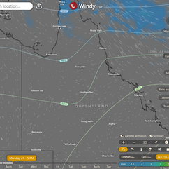
Windy.com ACCESS 4 Day 2PM Rain and Synoptic
Monday: Partly cloudy with isolated showers in certain areas. Clear skies elsewhere. Light to moderate winds shifting southwest in South East Queensland.
Tuesday: Western Queensland: Dry and sunny. Clouds elsewhere with showers in Far North, northern interior, and north Queensland later. Morning fog inland, patchy frost in south and central Queensland. Below average min. temps, above to near average max. temps.
Wednesday: Western Queensland sunny and dry, northern and central Queensland cloudy with showers, southeast and Far North Queensland partly cloudy. Morning fog inland, patchy frost in southwest. Eastern Queensland temperatures above average, western temperatures below average.
Thursday: East Queensland: Cloudy with showers, sunny and dry in the west. Above average temperatures in the east.
State


Windy.com ACCESS (Values are rainfall over 3 hours)
High pressure system over southeastern Australia brings cool air, settled weather and cold mornings. High moves east into Tasman Sea, allowing onshore winds, moisture, and warmer conditions. Trough forms inland on Tuesday, leading to cloud, showers in north and east. Trough weakens later in the week.
Min - Max - Rain

Regional Round-Up
North Tropical Coast and Tablelands:
Max temperature: 27 degrees, Min temperature: 11 degrees, Wind speed: 20 to 30 km/h, Wind direction: east to southeasterly, Rainfall: Slight chance of a shower, Other: Partly cloudy. Overnight temperatures falling to between 11 and 19 degrees with daytime temperatures reaching 21 to 27.
Herbert and Lower Burdekin:
The weather forecast includes temperatures ranging from 7 to the high 20s, light winds becoming northeasterly at 15 to 20 km/h, and a chance of overnight temperatures falling between 7 and 14 with a sunny outlook.
Central Coast and Whitsundays:
Max temperature: 26, Min temperature: 10, Wind speed: 15-20 km/h, Wind direction: NE to SE, Rainfall: None, Sunny with possible frost in the morning.
Peninsula:
The weather forecast includes a maximum temperature around 30°C, with minimum temperatures between 16 and 21°C, east to southeasterly winds at 15-25 km/h, a medium chance of showers near the east coast, slight chance elsewhere, and a partly cloudy sky.
Gulf Country:
The weather will be mostly sunny with maximum temperatures of 27 to 32, minimum temperatures of 8 to 17, light south to southeasterly winds of 15 to 20 km/h becoming light by midday, and no rainfall expected.
Northern Goldfields and Upper Flinders:
The weather forecast includes a maximum temperature of around 30 degrees, minimum temperatures between 5 and 13 degrees, east to northeasterly winds at 15 to 25 km/h, and sunny conditions with winds tending east to southeasterly at 15 to 20 km/h.
Capricornia:
The weather will be mostly sunny with morning frost inland, light winds, temperatures between -1 to 7 overnight, and reaching low to mid 20s during the day, with no rainfall indicated.
Central Highlands and Coalfields:
Max temperature: 21-26°C, Min temperature: -1 to 4°C, Wind speed: 15-20 km/h, Wind direction: East to northeasterly, Rainfall: Sunny, Other: Chance of fog in southeast, Areas of frost mainly in the south.
Central West:
Sunny with morning frost in the southeast, light winds becoming E to NE 20-30 km/h, overnight 1-6°C, daytime low to high 20s°C.
North West:
Max temperature: low to high 20s, Min temperature: 2-7, Wind speed: light, Wind direction: variable, Rainfall: N/A, Other: Sunny with patches of morning frost.
Channel Country:
Max temperature: 23°C, Min temperature: 2°C, Wind: Light becoming north to northeasterly 15-20 km/h, Rainfall: None, Weather: Sunny with morning frost in the northwest.
Maranoa and Warrego:
The weather forecast includes morning frost, morning fog in the east, light winds shifting to north to northeasterly 15-20 km/h in the morning then becoming light in the early afternoon, with overnight temperatures dropping to between minus 2 and 3 above zero and daytime temperatures in the low 20s, along with sunny conditions and a chance of rainfall.
Darling Downs and Granite Belt:
Max temperature: 22°C, Min temperature: 1°C, Wind speed: Light, Wind direction: NA, Rainfall: None, Other: Areas of frost and chance of fog in the morning, mostly sunny afternoon.
Wide Bay and Burnett:
Max temperature: low 20s; Min temperature: between -1 and 7; Wind speed: Light; Wind direction: N/A; Rainfall: Slight chance of a shower about K'gari, near zero chance elsewhere; Mostly sunny with patches of morning frost inland.
Southeast Coast:
Mostly sunny with morning frost in the south, slight chance of a shower along the coastal fringe, light winds, with max temp around 19-22°C and min temp between 3-9°C, wind speed and direction variable, near zero chance of rainfall.
Click here to support to Wally's Weather
National maps by Weatherzone (weatherzone.com.au)
State maps by Windy (Windy.com)
Weather forecast supplemented by Bureau of Meteorology (bom.gov.au)
Rainfall daily totals (https://meteologix.com/ )
AccuWeather (https://www.accuweather.com/)
Nine Weather (https://www.9news.com.au/weather)
Wally's Weather provides professionally researched data and information. Andrew aka 'Wally' has over 20 years of experience in meteorology research and data analysis. In 2023 finished top 4 for the AMOS national weather forecasting competition. The content here is provided as educational information aimed at providing the community and businesses with the tools required to determine local-based forecasts. IMPORTANT: The forecasts and information posted should never be used on their own to make business decisions as local influences.


Comments