Feb 26 2025 - Townsville Daily
- Feb 26, 2025
- 2 min read
Welcome to the new Townsville Daily forecast. This is specific for the Townsville region only.
Welcome our latest Legend Shout sponsor to join the legendary team to support the Townsville Daily forecast.

Knowledge. Skill. Experience. It’s how our agents maximise the value of your property. And it’s how we’ve sold more properties in Australasia than any other real estate group.
Ph: +61 0747 504 000
Email: townsville.qld@raywhite.com
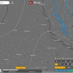
Queensland Synoptic
Queensland will be under the reign of a stubborn ridge thanks to a high chillin' in the Tasman Sea, with Tropical Cyclone Alfred adding some spice to the mix from afar before potentially crashing the party on the weekend. Meanwhile, a persistent trough will be hanging out in the southwest, probably debating whether it should stay or go.
Forecast for Herbert and Lower Burdekin:
Looks like we've got a mix of sun and clouds today, with a slight chance of a surprise shower popping up in the late morning and afternoon. Don't worry, those light winds will be keeping you cool, shifting from south to southeasterly in the morning before doing a little dance to the northeast in the late afternoon. Overnight, you can expect temperatures to drop to a comfy 18-23 degrees, while daytime highs will be hitting the low to mid 30s. So grab your sunscreen and umbrella, and get ready for whatever weather surprises are in store!
Forecast for Herbert and Lower Burdekin:

Warnings
Townsville hourly

Townsville 7 Day daily

Region 24 Hour Accumulated

Monsoon Special:
The next monsoon pulse due in Phase 6 (Gulf to Coral Sea) around the 26th March to 2nd April. Due to the 3rd pulse normally being weak, it tends to come around quicker so could be a week earlier.
We have arrived at the 26th, however I am waiting for the GFS to update which is around 10 to 11am, and may as well wait for the later updates of ECMWF and ACCESS G to see if we can get a clearer idea as I had expected by the 26th. As it is, the GFS is still out on it's own, now approaching the coast further North and the ECMWF and ACCESS beginning to agree with the skimming the coastline on the way South. If a crossing were to occur it appears to be more likely the 3rd to 4th of March, which means the 28th would provide a clearer idea of any potential crossing, still giving people 4 days preparation. Not that anyone needs much more notice, as this has been around for 3 days already.


ACCESS C 3 Hourly


Comments