Forecast - Sept 2 - Wally's Weather Australia
- Sep 1, 2024
- 9 min read
To get your daily forecast delivered free goto http://wallysweather.com.au/blog

Welcome Garry Thyer's Betta
Hyde Park Centre
Our prime daily forecast sponsors for August to October inclusive.
Address: Shop 8, Hyde Park Centre, Woolcock St, Hyde Park QLD 4812
Phone: (07) 4721 1211
National - Warnings - 4 Day - State - Min-Max-Rain - Regional Round-Up
National
Prepare yourself for a thrilling weather rollercoaster ride in the coming days! A feeble ridge will be lounging around in the eastern part of the state, while a weak trough in the far southwest will be meandering its way across the southern interior. Brace yourself for some unseasonably warm temperatures, thanks to those cheeky northerly winds ahead of the trough. But fear not, as a new high will be strutting its stuff across the state after the trough moves offshore on Monday night. This will bring back those lovely southeasterly winds, making eastern Queensland feel all cozy again. And just when you thought things were settling down, warmer northerly winds will make a grand comeback in the interior next week, followed by yet another trough sauntering into the southwest next weekend. Ah, the drama of Queensland weather never fails to entertain!


Synoptic | Temp/Rain | Wind | Sea Surface Temp
National Warnings
VIC: Gale Warning for several coasts, Strong Wind Warning for Port Phillip and Gippsland Lakes
WA: Strong Wind Warning for multiple coasts, Cancellation for Eucla Coast
SA: Severe Weather Warning for damaging winds in various regions
TAS: Severe Thunderstorm Warning for parts of Western, multiple flood warnings, Severe Weather Warning for destructive winds, Abnormally high tides and damaging surf warnings, Sheep Graziers Warning
NSW/ACT: Severe Weather Warning for damaging winds, Sheep Graziers Warning, Gale Warning for southern areas, Strong Wind Warning for coastal areas, Minor Flood Warning for Lachlan River
QLD: Cancellation of Wind Warning for Sunshine Coast Waters, Gold Coast Waters & K'gari Coast


WINDY.COM Extreme Weather
The 4 day forecast brought to you by our local businesses, you could have this spot with your details, support local, take out a Bold Shout ! $250 for a year, you get this and the website every day!


National 4 Day Forecast

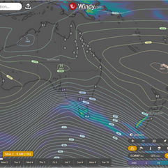


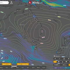
Windy.com NEW ACCESS 4 Day Accumulated Rain and Synoptic
Monday, 2nd September
Get ready to bask in the sunshine across most of the state, unless you're on the east coast north of Ingham where isolated showers might dampen your day. Don't forget your umbrella if you're venturing out near the east Peninsula coast north of Coen, as scattered showers are expected there. And if you're in the east from Cairns to Gladstone, you might have to navigate some patchy morning fog - just pretend you're in a mysterious movie scene. Watch out for those fresh and gusty west to southwesterly winds in southeast Queensland - they might just sweep you off your feet. The temperatures are set to be well above average in the interior south of Townsville and in the southeast, so make sure to have your sunscreen handy. Everywhere else can expect temperatures above average, so enjoy the warmth while it lasts. Mother Nature is certainly keeping us on our toes with this mix of weather patterns!
Tuesday, 3rd September
Well, folks, it appears that the sun has decided to grace us with its presence once again across most of our fine state. However, don't get too comfortable, as we can expect some pesky isolated showers lurking about the east coast. And let's not forget about our friends up north on the Tropical Coast, who will be dealing with some scattered showers. Now, I hate to be the bearer of bad news, but those fresh and gusty southeasterly winds are back at it again, potentially causing some elevated fire dangers in the interior and west. So, maybe hold off on that backyard bonfire for now. As for temperatures, it seems like Mother Nature couldn't make up her mind. Above-average temperatures will be the norm in much of the interior, while the southeast and southwest will be slightly below average. So, grab your sunscreen and your sweater, folks – it's going to be a wild ride out there.
Wednesday, 4th September
Looks like the sun is up to its usual antics across most of the state today. Just a dash of clouds and a sprinkle of isolated showers along the east coast and nearby inland areas. Meanwhile, up north near Carmila, showers are getting a bit more ambitious and spreading out like a teenager's acne. Keep an eye out for those northeasterly winds, they're feeling fresh and gusty today. And don't forget about the elevated fire dangers in the interior and western parts of the state - it's like Mother Nature's way of saying "don't play with matches, kids". Temperatures are feeling a bit rebellious today, with above-average highs in the west and south, and slightly below-average temperatures in the east. It's like the weather can't make up its mind, just like your indecisive ex who can never choose what to have for dinner.
Thursday, 5th September
Looks like Mother Nature is in a bit of a mood today. Sunny skies are expected across most of the state, with just a touch of drama in the form of isolated showers on the east coast and nearby inland areas. If you happen to be north of Carmila, you might want to keep an eye out for those showers turning into a full-blown scatterfest. But wait, there's more! Fresh and gusty winds from the north to northeast could potentially turn up the heat and elevate fire dangers in the interior and western parts of the state. So, if you're thinking of roasting marshmallows over an open fire this weekend, you might want to think again. Temperatures are also playing tricks on us, with the west and south getting a taste of summer while the east is left feeling a bit chilly. It's like Mother Nature is trying to keep us on our toes, just for fun. Oh, the joys of living in a land of unpredictable weather!
State


Windy.com ACCESS (Rainfall at 6 hour points over the next 24 hours, 10pm, 4am, 10am, 4pm)
Min - Max - Rain

Regional Round-Up
North Tropical Coast and Tablelands:
Expect a bright day with a touch of mystery as the winds play hide and seek from the east to southeasterly at 15 to 25 km/h - don't worry, they'll show up eventually. Nighttime temperatures will cool down to a cozy 12 to 19, perfect for a good night's sleep or stargazing on the porch. Daytime will bring the heat between 26 to 32 - it's a wide range, so dress for a wardrobe change. Stay dry as there's no rainfall expected, giving you the green light to enjoy the day without any surprise showers.
Herbert and Lower Burdekin:
Expect a sunny day with some patchy fog in the morning, mainly in the south, so be prepared for a mysterious start. Light winds will then shift to an east to northeasterly direction at a leisurely 15 to 20 km/h in the afternoon, before deciding to take a break in the evening, showcasing the wind's inconsistent work ethic. Temperatures will drop overnight to a cozy 12-17 degrees, creating the perfect excuse for extra blankets, while daytime temperatures will soar to a toasty 30 degrees, encouraging all to bask in the warmth. Chance of rainfall is as rare as discovering a unicorn in your backyard, so plan outdoor activities without fear of a sudden downpour.
Central Coast and Whitsundays:
With patchy fog in the early morning, get ready to enjoy a sunny day ahead! Expect light winds that will switch from east to northeasterly at around 15 to 20 km/h in the early afternoon, before becoming gentle in the evening. As night falls, temperatures will drop to a pleasant 13 to 16 degrees, after daytime highs of 27 to 33 degrees. Don't forget your sunscreen!
Peninsula:
Feeling hot, hot, hot! 😎 Expect mostly sunny skies, with a tiny chance of a shower on the east coast and basically no chance anywhere else, so bring your sunscreen. Winds will be blowing from the east at 20 to 30 km/h, giving you that breezy vacation vibe. Temperatures will cool down overnight to a mild 15 to 22 degrees, while daytime will sizzle between 31 to 38 degrees. Stay cool, folks!
Gulf Country:
Expect a sunny day with light winds shifting around like a confused compass needle, eventually settling on a southeasterly direction at a zippy 20 to 30 km/h by early afternoon. Overnight, temperatures will dip to a moderate 18°C, while during the day, brace yourself for a scorcher in the mid to high 30s. Don't forget your sunscreen and water bottle!
Northern Goldfields and Upper Flinders:
Expect a sunny day with a touch of fog early on in the southeast. Wind playing mind games, starting from the east and swirling to the northeasterly at 15 to 20 km/h, only to pivot to east-southeasterly at a brisk 25 to 35 km/h by noon. Nighttime hits a nippy 13-17°C, while daytime tempts folks with a balmy 32-38°C. Keep cool, folks, it's a mercurial mix out there.
Capricornia:
Expect to wake up to fog so patchy, you might think you're in a misty dream. But fear not, the sun will blaze at full strength in the afternoon.
You can greet the day with light winds that won't dare muss up your hair.
Temperatures will play a game of hide and seek, dropping to a cool 11-16°C overnight only to soar to a scorching 30°C during the day.
Rainfall won't dare make an appearance, ensuring your plans won't get rained on.
And for other weather info, just sit back and enjoy the sunshine - it's all smooth sailing today!
Central Highlands and Coalfields:
It will be sunny with some patchy fog along the coast in the morning; expect a gentle breeze changing direction throughout the day from northeast to southeasterly to southeast to southwesterly. Nighttime will cool down to around 13 degrees, while daytime will heat up to the low to mid 30s, so you might want to pack your sunscreen and sunglasses to soak up those rays. Keep your umbrella handy as there's no rain in sight, but you never know when a surprise shower might decide to crash the sun party!
Central West:
Hotter than a dragon's breath, with morning breezes doing a dance from the northeast at 15 to 20 km/h before switching to a southerly, more determined 20 to 30 km/h later on, as temperatures plummet overnight to a cool 13-16 degrees, only to ramp back up to the mid to high 30s during the day. Keep those ice cubes handy!
North West:
Clear skies and sunshine accompanied by mild breezes shifting from northeast to southeasterly at 15-25 km/h in the morning, ramping up to 25-35 km/h by early afternoon, ensuring you'll have an exhilarating hairdo. Temperatures ranging from pleasant 14 to 19 overnight at cool movie-watching level, but soaring to a toasty 40 during the day so you may want to pack sunscreen and a portable fan. No mention of rain, so no need to worry about watering your plants or bringing an umbrella, unless you want to stay shaded in the scorching heat.
Channel Country:
Hold onto your hats as the winds pick up speed, blowing south to southeasterly at 15 to 20 km/h but revving things up to 25 to 35 km/h by morning. Catch those Zs with overnight lows chilling between 14 and 17, then brace yourself for the sizzle with daytime temps soaring from 28 all the way up to a scorching 36. Don't forget your sunscreen!"
Maranoa and Warrego:
It'll be a toasty day with temperatures peaking at around 30°C, falling to a mild 14°C at night; expect a breezy morning turning into a blustery day as winds shift from light to southerly at 20-30 km/h, with a touch of that cheeky southwesterly flair at 25-35 km/h in the morning.
Darling Downs and Granite Belt:
Prepare for a weather rollercoaster today with a hot high of 30 and a low of 14 overnight. Hold onto your hat as winds whip from the north to northwesterly at 15-20 km/h, then do a U-turn to the southwesterly at 25-35 km/h in the morning. No rain in sight, so slather on the sunscreen and enjoy the sunny day ahead!
Wide Bay and Burnett:
Patchy fog early on will give way to a delightful sunny day, perfect for a picnic or a relaxing stroll. Expect some breezy moments with northwesterly winds at 15-25 km/h, later shifting to a milder south to southwesterly flow at 15-20 km/h. Temperatures at night will dip to a comfy 12-16 degrees, while daytime highs are set to soar into the pleasing low 30s, making for a toasty end to your day. Remember your sunscreen!
Southeast Coast:
Sunny skies with a slight twist-Put on your windbreaker as breezy northwesterly winds at 15-20 km/h will do a tap dance before switching to a more vigorous west to southwesterly direction at 25-35 km/h in the late morning and early afternoon, so hold onto your hats! Overnight, temperatures will cool to a cozy 15-18 degrees, giving you that perfect excuse to snuggle up. Daytime, however, will bring the heat with low to mid 30s temperatures, so grab your sunscreen and stay cool!
Click here to support to Wally's Weather
National maps by Weatherzone (weatherzone.com.au)
State maps by Windy (Windy.com)
Weather forecast supplemented by Bureau of Meteorology (bom.gov.au)
Rainfall daily totals (https://meteologix.com/ )
AccuWeather (https://www.accuweather.com/)
Nine Weather (https://www.9news.com.au/weather)
Wally's Weather provides professionally researched data and information. Andrew aka 'Wally' has over 20 years of experience in meteorology research and data analysis. In 2023 finished top 4 for the AMOS national weather forecasting competition. The content here is provided as educational information aimed at providing the community and businesses with the tools required to determine local-based forecasts. IMPORTANT: The forecasts and information posted should never be used on their own to make business decisions as local influences.


Comments