

Mar 6 2025 - Townsville Daily
- Mar 2, 2025
- 3 min read
Welcome to the new Townsville Daily forecast. This is specific for the Townsville region only.
Welcome our latest Legend Shout sponsor to join the legendary team to support the Townsville Daily forecast.

Knowledge. Skill. Experience. It’s how our agents maximise the value of your property. And it’s how we’ve sold more properties in Australasia than any other real estate group.
Ph: +61 0747 504 000
Email: townsville.qld@raywhite.com
Monsoon Special:
The next monsoon pulse due in Phase 6 (Gulf to Coral Sea) around the 26th March to 2nd April. Due to the 3rd pulse normally being weak, it tends to come around quicker so could be a week earlier.
Alfred now a Category 2 system again, here is the detail and plot. Barely any movement since 2am this morning but there would not be expected to be much. He should set sail more today,

Alfred is currently stuck in place because a high-pressure system further south is pushing it west like a "conveyor belt", while a ridge along the coast is holding it back. This stalling could delay its movement or even shift its location. If the ridge weakens, Alfred might move south instead of north, but for now, forecasts just show a delay. My thoughts are a little loop and it will pick up pace again, maybe not to 13km/h but somewhere in between so the forecasts will probably adjust again today to have it arriving sooner than it had last night.

The next 72 Hours
The before and afters are what we are looking at. Before EC,GFS, ACCESS and then After EC, GFS and ACCESS. ACCESS G is showing the most intense, and all appear to be arriving around midnight at the most intense. After is a little different, positioning is different and timing. ACCESS and EC generally continue West but GFS shifts North to the Sunny Coast and takes a lot longer to cross.


Looking at the ACCESS C model, the intensity is less than ACCESS G, arrives about 9am Friday, but we don't have the crossing times yet.

JTWC Summary 1am
Tropical Cyclone Alfred Strengthening – Currently at 55 knots (100 km/h), Alfred is expected to intensify to 60 knots (110 km/h) before making landfall just north of Brisbane in the next 48 hours.
Slow-Moving but Dangerous – The cyclone is tracking westward at a slow pace, leading to prolonged heavy rain, strong winds, and coastal impacts for southeast Queensland and northern New South Wales.
Heavy Rain & Flash Flooding Likely – Due to its slow movement, intense rainfall is expected over coastal regions, increasing the risk of flash flooding and dangerous road conditions.
Damaging Winds & Storm Surge – Wind gusts could reach 110 km/h, with abnormally high tides and coastal erosion likely, especially around exposed beaches and low-lying areas.
Prepare Now – Residents should secure loose objects, avoid coastal areas, and stay updated with emergency alerts at bom.gov.au.

Queensland Synoptic
Tropical Cyclone Alfred is on its way to crash the southeast coast, causing chaos near Sandy Cape, with a weak trough hanging around the interior for a while. As Alfred weakens overland on Friday and disappears by Sunday, a ridge will bring more moisture to the northeast coast thanks to a high moving across the Tasman Sea.
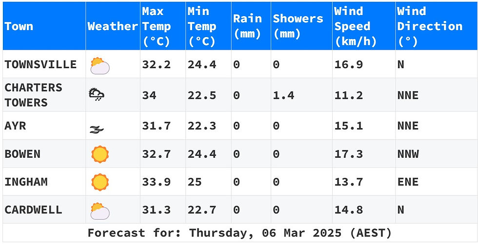
Forecast for Herbert and Lower Burdekin:
Looks like we've got a mix of sun and clouds today, with a sprinkle or two possible inland later on. Don't worry, the chances of rain everywhere else are slim to none. And hey, a thunderstorm might just pop up by late morning for a little extra excitement! Expect some light winds throughout the day, turning north to northeasterly in the afternoon before calming down in the evening. Overnight, temps will cool off to the low to mid 20s, while daytime highs will hit the low to mid 30s. So grab your sunscreen and umbrella, just in case - you never know what the weather gods have in store for us today!
Forecast for Herbert and Lower Burdekin:
Warnings
06/04:52 EST Tropical Cyclone Forecast Track Map
Townsville hourly

ACCESS C 3 Hourly


Region 24 Hour Accumulated

Townsville 7 Day daily


Comments