
To get your daily forecast delivered free goto http://wallysweather.com.au/blog

Welcome to our latest Bold Shout supporter:
Precision Painting NQ for all your painting needs!
Ph 0435779552
Bold Shout is $250 a year to have your ad in this post every day plus other ad hoc posts on Facebook.
 Our products include tyres, rims, trailer parts and accessories, automotive lights and much more! We stock quality brands like Michelin, BF Goodrich to name a few. Our services include suspension, tyre-fitting, tyre repairs, wheel balancing, wheel alignment and much more! We pride ourselves on quality workmanship to ensure your car is in the best condition for safe travelling!! Website: https://jmtyre.com.au/ Facebook: https://www.facebook.com/GOLDINVESTMENTGROUPTOWNSVILLE Phone: (07) 4721 5599 |
National Showers and storms are sweeping across QLD, the Top End, and the eastern interior of the NT, along with the northern and eastern regions of NSW, driven by unstable winds. Meanwhile, TAS and southern VIC are experiencing showers under cool winds. The rest of the area remains mostly dry and settled, thanks to high pressure, except for western WA, where hot and dry winds are prevailing. Synoptic | Temp/Rain | Wind | Sea Surface Temp |
The 4 day forecast brought to you by our local businesses, you could have this spot with your details, support local, take out a Bold Shout! $250 for a year, you get this and the website every day! |
4 Day Forecast
|
Warnings
Storms - Extreme Weather - Fire danger |


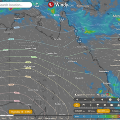
State A high-pressure system in the Tasman Sea is weakening but maintaining a ridge over the eastern state, while another high-pressure system south of Australia strengthens, bringing stable weather after a passing trough. An approaching upper low might enhance rainfall in southeastern and central Queensland, while a trough in the north could lead to a weak tropical low and increased rainfall in the far northern Peninsula. ACCESS (Values are rainfall over 3 hours) |


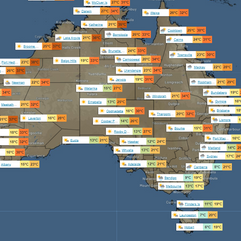
State Region Round-up North Tropical Coast and Tablelands: Max temperature: 31°C, min temperature: 18°C, wind speed: 25-35 km/h, wind direction: east to southeasterly, rainfall: showers likely near coast, slight chance elsewhere, other: partly cloudy with chance of thunderstorms in the north. Herbert and Lower Burdekin: The weather will be partly cloudy with a slight chance of showers in the north, light winds becoming easterly 15 to 20 km/h, and daytime temperatures reaching 28 to 33 degrees with overnight temperatures falling to between 18 and 22 degrees. Central Coast and Whitsundays: Max temperature: 33°C, Min temperature: 19°C, Wind speed: 15-25 km/h, Wind direction: Easterly, Rainfall: Slight chance of a shower, Other: Partly cloudy, southeasterly winds becoming light. Peninsula: Max temperature in the low to mid 30s, min temperature in the low to mid 20s, wind speed easterly to southeasterly 20 to 30 km/h, partly cloudy with high chance of showers in the north of Weipa, slight chance elsewhere, possibility of severe thunderstorm. Gulf Country: Max temperature: low to mid 30s, Min temperature: low 20s, Wind speed: Light, Wind direction: East to southeasterly, Rainfall: Chance of thunderstorm in north, Other: Mostly sunny day. Northern Goldfields and Upper Flinders: The max temperature is in the low to mid 30s with overnight temperatures falling to between 18 and 21, winds east to southeasterly 20 to 30 km/h becoming light in the late evening, and partly cloudy conditions expected with no mention of rainfall. Capricornia: The weather will have temperatures between 16-30°C, light winds, slight chance of showers, thunderstorms in the southwest, and partly cloudy conditions. Central Highlands and Coalfields: Max temperature: 30°C, Min temperature: 16-20°C, Wind speed: Light winds becoming easterly 15-20 km/h, Wind direction: Easterly, Rainfall: Near zero chance, Other: Partly cloudy with slight chance of a shower in the south, near zero chance of rain elsewhere, chance of a thunderstorm in the south from late morning. Central West: Max temperature: low to mid 30s; Min temperature: 18-21; Wind speed: 15-20 km/h; Wind direction: east-northeasterly turning south-southeasterly; Rainfall: slight chance of shower in southeast, near zero elsewhere; Other: Partly cloudy with chance of thunderstorm south of Longreach. North West: The weather will be partly cloudy with light winds changing to southeasterly at 20 to 30 km/h in the morning, with overnight temperatures dropping to the low 20s and daytime temperatures reaching the low to mid 30s, accompanied by a possibility of rainfall. Channel Country: Max temperature: 34°C, Min temperature: 17°C, Wind speed: 25-35 km/h, Wind direction: Southerly, Rainfall: Chance of thunderstorm in the southeast, Conditions: Mostly sunny Maranoa and Warrego: Maximum temperature: 30°C, Minimum temperature: 16-19°C, Wind: Light becoming north to northwesterly then southerly, Rainfall: Medium chance of showers in the east, slight chance elsewhere, Other: Partly cloudy with a chance of thunderstorms in the morning and afternoon. Darling Downs and Granite Belt: Max temperature: mid to high 20s, Min temperature: 14-17, Wind speed: Light becoming 15-20 km/h, Wind direction: West to southwesterly, Rainfall: High chance showers south, medium elsewhere, Other: Partly cloudy, chance of fog in east early morning, severe thunderstorm possible in Granite Belt. Wide Bay and Burnett: Max temperature: around 30, Min temperature: between 15 and 19, Wind speed: light, Wind direction: - , Rainfall: medium chance of showers, Other: Partly cloudy with fog inland, chance of thunderstorm. Southeast Coast: Max temperature in the mid to high 20s, min temperature falling to between 15 and 19, light winds, partly cloudy with chance of fog inland in the early morning, medium chance of showers in the late afternoon and evening, and a chance of severe thunderstorm with damaging winds, heavy falls, and large hail in the southern border ranges from late morning. |
Click here to support to Wally's Weather
National maps by Weatherzone (weatherzone.com.au)
State maps by Windy (Windy.com)
Weather forecast supplemented by Bureau of Meteorology (bom.gov.au)
Rainfall daily totals (https://meteologix.com/ )
AccuWeather (https://www.accuweather.com/)
Nine Weather (https://www.9news.com.au/weather)
Wally's Weather provides professionally researched data and information. Andrew aka 'Wally' has over 20 years of experience in meteorology research and data analysis. In 2023 finished top 4 for the AMOS national weather forecasting competition. The content here is provided as educational information aimed at providing the community and businesses with the tools required to determine local-based forecasts. IMPORTANT: The forecasts and information posted should never be used on their own to make business decisions as local influences.