Morning Weather - April 24 - Wally's Weather Australia
- Apr 23, 2024
- 1 min read
To get your daily forecast delivered free goto http://wallysweather.com.au/blog
 Our products include tyres, rims, trailer parts and accessories, automotive lights and much more! We stock quality brands like Michelin, BF Goodrich to name a few. Our services include suspension, tyre-fitting, tyre repairs, wheel balancing, wheel alignment and much more! We pride ourselves on quality workmanship to ensure your car is in the best condition for safe travelling!! Website: https://jmtyre.com.au/ Facebook: https://www.facebook.com/GOLDINVESTMENTGROUPTOWNSVILLE Phone: (07) 4721 5599 |
ANZAC Day So far looks like mainly fine conditions for the Northern tropics of QLD, isolated showers for the region near Innisfail that was forecast yesterday appears to have disappeared from the forecast today. Temps cooling down as well as the new high moves into position and winds easing back as well. |
National A cool front is moving in, bringing chilly winds and rain to Tasmania, Victoria, and the southeastern part of South Australia. In Tasmania's high mountains, it's even snowing! Up in the far north of Queensland and the Top End of the Northern Territory, there are showers and thunderstorms happening. Eastern Queensland and northeastern New South Wales are getting showers too, thanks to a moist breeze blowing in from the southeast. Everywhere else is pretty clear and sunny because of a high-pressure system. Synoptic | Temp/Rain | Wind | Sea Surface Temp |
The 4 day forecast brought to you by our local businesses, you could have this spot with your details, support local, take out a Bold Shout! $250 for a year, you get this and the website every day! |
4 Day Forecast
|
Warnings
Storms - Extreme Weather - Fire danger |

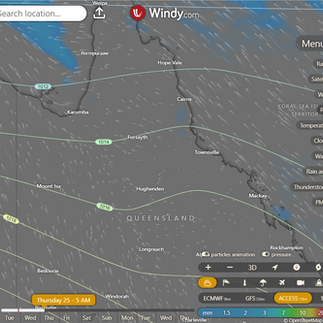


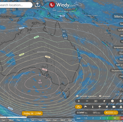

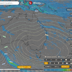

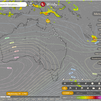


State Tasman Sea high moving east, weak trough in SE Australia Wednesday, new high over Great Australian Bight later this week, weakening low in Coral Sea moving east by Wednesday. ACCESS (Values are rainfall over 3 hours) |


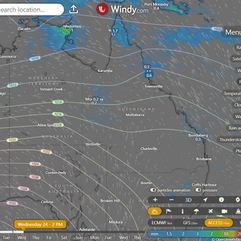


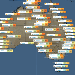
State Region Round-up North Tropical Coast and Tablelands: Max temperature: 29°C, Min temperature: 17°C, Wind: East to southeasterly 20-30 km/h, Rainfall: High chance of showers near coast, medium elsewhere, Other: Partly cloudy Herbert and Lower Burdekin: Max temperature: Around 30°C, Min temperature: Between 17-20°C, Wind: Southeasterly 15-20 km/h, Rainfall: None expected Central Coast and Whitsundays: Max temperature: 31, Min temperature: 15, Wind speed: 15-25 km/h, Wind direction: South to southeasterly, Rainfall: None, Summary: Mostly sunny. Peninsula: The weather forecast includes maximum temperature in the low 30s, minimum temperature in the low to mid 20s, wind speeds increasing from light to 20-30 km/h east to southeasterly, light winds in the late evening, a medium chance of showers north of Coen with a slight chance elsewhere, and the possibility of a thunderstorm in the west in the late morning and afternoon. Gulf Country: Maximum temperature: low to mid 30s, Minimum temperature: 19 to 23, Wind speed: easterly 15 to 25 km/h becoming southeasterly 15 to 20 km/h, Wind direction: Easterly becoming southeasterly, Rainfall: None, Conditions: Sunny with overnight temperatures falling to between 19 and 23. Northern Goldfields and Upper Flinders: Mostly sunny with daytime temperature around 30, overnight temperature 16-20, wind easterly 15-20 km/h becoming east to southeasterly 20-30 km/h in the morning and light in the late evening, no rainfall. Capricornia: Mostly sunny with max temperatures in the mid to high 20s, min temperatures between 13 and 18, wind south to southeasterly 15 to 20 km/h becoming light in the late evening. Central Highlands and Coalfields: 26-31°C, 12-15°C, light winds becoming southeasterly 15-25 km/h, southeast, no rainfall, Mostly sunny with fog in the southeast in the early morning. Central West: Mostly sunny with maximum temperature around 30, minimum temperature between 13-19, winds starting east to southeasterly and becoming easterly at 20-30 km/h in the morning before turning southeasterly 15-20 km/h in the middle of the day, and no rainfall expected. North West: Max temperature reaching the low 30s, min temperature around 19, wind east to southeasterly 15-25 km/h becoming light in the evening, rainfall unlikely, and partly cloudy. Channel Country: The weather will be partly cloudy with a maximum temperature of around 30, minimum temperature between 16 and 20, southeasterly winds at 20 to 30 km/h turning southerly in the early afternoon, and no rainfall expected. Maranoa and Warrego: The weather will be partly cloudy with possible fog in the east in the early morning, transitioning from light winds to south to southeasterly 15 to 25 km/h in the late afternoon, with temperatures ranging from 11 to 30 degrees. Darling Downs and Granite Belt: Maximum temperature in mid 20s, minimum temperature between 9 and 14, light winds, partly cloudy with a chance of fog in the early morning and no significant rainfall. Wide Bay and Burnett: Max temperature in the mid 20s, min temperature between 13 and 17, light winds becoming southeasterly 15 to 20 km/h, near zero chance of rain, partly cloudy with chance of fog in the south and slight chance of a shower along the coastal fringe in the morning. Southeast Coast: Max temperature: mid to high 20s, Min temperature: 12-17, Wind speed: Light, Wind direction: N/A, Rainfall: Slight chance of shower, Partly cloudy with fog inland in the early morning. |
Click here to support to Wally's Weather
National maps by Weatherzone (weatherzone.com.au)
State maps by Windy (Windy.com)
Weather forecast supplemented by Bureau of Meteorology (bom.gov.au)
Rainfall daily totals (https://meteologix.com/ )
AccuWeather (https://www.accuweather.com/)
Nine Weather (https://www.9news.com.au/weather)
Wally's Weather provides professionally researched data and information. Andrew aka 'Wally' has over 20 years of experience in meteorology research and data analysis. In 2023 finished top 4 for the AMOS national weather forecasting competition. The content here is provided as educational information aimed at providing the community and businesses with the tools required to determine local-based forecasts. IMPORTANT: The forecasts and information posted should never be used on their own to make business decisions as local influences.


Comments