Morning Weather - April 27 - Wally's Weather Australia
- Apr 26, 2024
- 1 min read
To get your daily forecast delivered free goto http://wallysweather.com.au/blog
 Our products include tyres, rims, trailer parts and accessories, automotive lights and much more! We stock quality brands like Michelin, BF Goodrich to name a few. Our services include suspension, tyre-fitting, tyre repairs, wheel balancing, wheel alignment and much more! We pride ourselves on quality workmanship to ensure your car is in the best condition for safe travelling!! Website: https://jmtyre.com.au/ Facebook: https://www.facebook.com/GOLDINVESTMENTGROUPTOWNSVILLE Phone: (07) 4721 5599 |
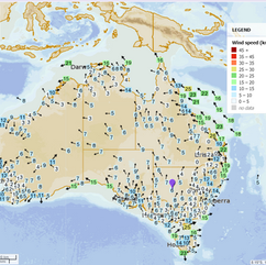
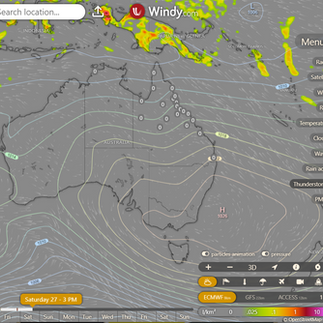
National Light rain is expected along the coasts of Queensland, southwestern Western Australia, and New South Wales due to moist winds surrounding a high-pressure system. Western Tasmania will experience showers, possibly heavy, as a cold front approaches. Everywhere else will remain clear and dry thanks to a large area of high pressure. Synoptic | Temp/Rain | Wind | Sea Surface Temp |
The 4 day forecast brought to you by our local businesses, you could have this spot with your details, support local, take out a Bold Shout! $250 for a year, you get this and the website every day! |
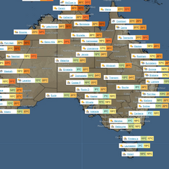
4 Day Forecast
|
Warnings
Storms - Extreme Weather - Fire danger |


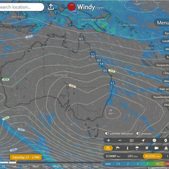


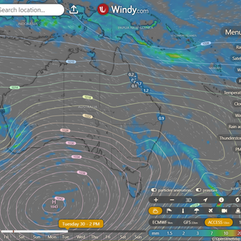


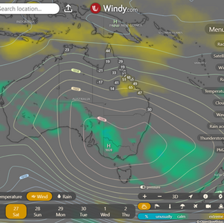


State High pressure over Great Australian Bight brings ridge over state. Southeasterly wind surge heads north on east coast. High moves east, reaching Tasman Sea on Saturday and drifting east. Weak trough in western Queensland on Sunday deepens slightly and moves east on Monday, crossing southeast coast and weakening Tuesday. Strong high in Southern Ocean brings new ridge over state after trough. Possible trough near southeast coast next weekend.0 ACCESS (Values are rainfall over 3 hours) |


State Region Round-up North Tropical Coast and Tablelands: Maximum temperature: 29°C, Minimum temperature: 16°C, Wind speed: 25-35 km/h from east to southeasterly direction, Rainfall: Medium chance of showers near the coast, slight chance elsewhere, Weather: Partly cloudy. Herbert and Lower Burdekin: The weather forecast includes a max temperature of around 30°C, a min temperature of 16-20°C, light winds becoming easterly at 15-25 km/h, near zero chance of rain, and partly cloudy skies with a slight chance of showers in the north in the evening. Central Coast and Whitsundays: Max temperature: 30°C, Min temperature: 15°C, Wind: ESE 20-30 km/h, Rainfall: Medium chance of showers, Partly cloudy. Peninsula: The summary of the weather forecast is max temperature in the low 30s, min temperature in the low 20s, wind speed increasing from 15-20 km/h becoming easterly 25-35 km/h, a chance of a shower near the east coast, and partly cloudy conditions. Gulf Country: Maximum temperature in the low 30s, minimum temperature between 17 and 22, winds south to southeasterly 15 to 20 km/h, shifting to east to southeasterly 20 to 30 km/h in the morning before becoming light in the early afternoon, and "Sunny" conditions. Northern Goldfields and Upper Flinders: The maximum temperature will be around 30°C with easterly winds at 20 to 30 km/h, clear skies with overnight temperatures dropping to 15-19°C and no rainfall expected. Capricornia: High 20s, 13-19, 25-35 km/h, east to southeasterly, near zero rain, partly cloudy with medium chance of showers near coast in the morning. Central Highlands and Coalfields: Max temperature: 30°C, Min temperature: 9°C, Wind speed: 20-30 km/h, Wind direction: East to southeasterly becoming easterly, Rainfall: Slight chance of a shower in the northeast, near zero chance elsewhere, Other: Partly cloudy. Central West: Max temperature: 30°C, Min temperature: 10-15°C, Wind speed: 15-20 km/h becoming light in the morning then 20-30 km/h, Wind direction: Southeasterly becoming easterly, Rainfall: N/A, Other: Sunny. North West: The max temperature will reach the low 30s with southeasterly winds increasing to 20-30 km/h in the morning, shifting to south to southeasterly and light in the evening, while overnight temperatures will drop to 11-17. Channel Country: The summary for the weather forecast is: Max temperature in the mid to high 20s, with overnight temperatures falling to around 11, winds southeasterly at 20 to 30 km/h, and 'Sunny' conditions with no rainfall expected. Maranoa and Warrego: The weather will be mostly sunny with light winds becoming east to northeasterly 15 to 20 km/h in the morning, then light in the late afternoon, with temperatures ranging from 5 to 9°C overnight and reaching the mid to high 20s during the day, with no mention of rainfall. Darling Downs and Granite Belt: The weather will be mostly sunny, with temperatures ranging from 8-11°C overnight and reaching the low to mid 20s during the day, accompanied by light winds becoming easterly at 15-20 km/h in the morning before becoming light in the evening. Wide Bay and Burnett: Mostly sunny with daytime temperatures reaching the low to high 20s, overnight temperatures falling to between 12 and 17, light winds becoming southeasterly 20 to 30 km/h in the morning then becoming light in the evening, medium chance of showers along the coastal fringe, near zero chance elsewhere. Southeast Coast: The weather will have daytime temperatures in the low to mid 20s, with overnight temperatures falling to 12-16, light winds becoming south to southeasterly 15 to 25 km/h, partly cloudy conditions, high chance of showers along the coastal fringe, slight chance elsewhere, and becoming light in the late evening. |
Click here to support to Wally's Weather
National maps by Weatherzone (weatherzone.com.au)
State maps by Windy (Windy.com)
Weather forecast supplemented by Bureau of Meteorology (bom.gov.au)
Rainfall daily totals (https://meteologix.com/ )
AccuWeather (https://www.accuweather.com/)
Nine Weather (https://www.9news.com.au/weather)
Wally's Weather provides professionally researched data and information. Andrew aka 'Wally' has over 20 years of experience in meteorology research and data analysis. In 2023 finished top 4 for the AMOS national weather forecasting competition. The content here is provided as educational information aimed at providing the community and businesses with the tools required to determine local-based forecasts. IMPORTANT: The forecasts and information posted should never be used on their own to make business decisions as local influences.


Comments