Morning Weather - April 9 - Wally's Weather Australia
- Apr 8, 2024
- 1 min read
To get your daily forecast delivered free goto http://wallysweather.com.au/blog
 Our products include tyres, rims, trailer parts and accessories, automotive lights and much more! We stock quality brands like Michelin, BF Goodrich to name a few. Our services include suspension, tyre-fitting, tyre repairs, wheel balancing, wheel alignment and much more! We pride ourselves on quality workmanship to ensure your car is in the best condition for safe travelling!! Website: https://jmtyre.com.au/ Facebook: https://www.facebook.com/GOLDINVESTMENTGROUPTOWNSVILLE Phone: (07) 4721 5599 |
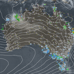
National Brisk winds and showers hit southern regions of Western Australia, South Australia, Tasmania, Victoria, and southern New South Wales as a cold front moves in, with showers expected to turn into light snow in the alps and highlands of Tasmania. Meanwhile, showers and storms are forecasted for the northern and eastern parts of Queensland. Tropical Cyclone Olga is anticipated to weaken significantly, situated far north of Western Australia. Synoptic | Temp/Rain | Wind | Sea Surface Temp |
The 4 day forecast brought to you by our local businesses, you could have this spot with your details, support local, take out a Bold Shout! $250 for a year, you get this and the website every day! |
4 Day Forecast
|
Warnings
Storms - Extreme Weather - Fire danger |


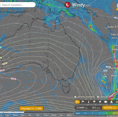


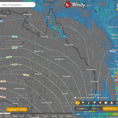
State Trough moving offshore, cold front approaching SE Australia, high pressure bringing settled weather across Queensland, coastal showers later in the week. ACCESS (Values are rainfall over 3 hours) |


State Region Round-up North Tropical Coast and Tablelands: The weather will be warm with a maximum temperature of 32°C, light winds, a slight chance of showers in the afternoon and evening, a chance of thunderstorms inland, and overnight temperatures between 19-23°C. Herbert and Lower Burdekin: Expect a partly cloudy day with light winds, reaching temperatures between 30 and 35, dropping to 19 to 22 overnight, with minimal rainfall and variable wind direction. Central Coast and Whitsundays: Mostly sunny with fog possible in the early morning, light winds becoming southwesterly 15 to 20 km/h, temperatures between 17 and 21 overnight and low to mid 30s during the day. Peninsula: Max temperature in the low 30s, minimum temperature in the low to mid 20s, light winds, Partly cloudy. Very high chance of showers in the west, medium chance elsewhere. The chance of a thunderstorm. Gulf Country: Mostly sunny with medium chance of showers in the north, near zero chance elsewhere and a chance of thunderstorm; temperatures range from low to mid 30s during the day and fall to 19-25 degrees overnight with windy conditions. Northern Goldfields and Upper Flinders: Mostly sunny with a slight chance of a shower in the north and near-zero chance elsewhere, with a chance of a thunderstorm in the north, light winds becoming south to southeasterly 15 to 25 km/h in the morning, and temperatures ranging between 17 and 23 degrees overnight and reaching the low to mid 30s during the day. Capricornia: The maximum temperature will be around 30 degrees with minimum temperatures falling to between 15 and 21 overnight, light winds becoming southerly 15 to 25 km/h in the morning, lowered chance of fog in the early morning, mostly sunny conditions, and a decrease in wind speed to light in the evening with no mention of rainfall. Central Highlands and Coalfields: The forecast includes max temperature of 33°C, min temperature of 13°C, wind speed starting light and becoming southerly 15-20 km/h, wind direction changing to light in the evening, rainfall is not mentioned, and it will be mostly sunny with a chance of fog in the northeast in the early morning. Central West: Maximum temperature: 30, Minimum temperature: 13-17, Wind speed: Light becoming 20-30 km/h, Wind direction: Southerly, Rainfall: None, Other: Sunny. North West: The maximum temperature will reach the low 30s with overnight temperatures falling to between 15 and 19, winds southerly ranging from 15 to 20 km/h becoming light before dawn then strengthening to 25 to 35 km/h early in the morning, and it will be sunny with no rainfall. Channel Country: Max temperature: 31°C, Min temperature: 16°C, Wind speed: 25 to 35 km/h, Wind direction: Southerly, Rainfall: N/A, Condition: Sunny. Maranoa and Warrego: The maximum temperature will be in the mid to high 20s, with overnight temperatures around 13 and wind speeds becoming south to southwesterly at 25 to 35 km/h, while also being sunny with light winds. Darling Downs and Granite Belt: Max temperature: mid to high 20s, Min temperature: around 12, Wind speed: southwesterly 25 to 35 km/h, Wind direction: Light winds becoming southwesterly, Rainfall: Mostly sunny with a chance of fog in southeast in the early morning. Wide Bay and Burnett: Expect a partly cloudy day with light winds, some possible showers near the coast in the morning, temperatures ranging from the mid to high 20s during the day and falling to between 14 and 20 overnight, with a chance of a thunderstorm in the morning near K'gari and near zero chance of rain elsewhere. Southeast Coast: Max temperature in the mid to high 20s, min temperature between 14 and 18, light winds becoming southwesterly 15 to 25 km/h, mostly sunny with chance of fog in the south early morning, no rainfall. |
Click here to support to Wally's Weather
National maps by Weatherzone (weatherzone.com.au)
State maps by Windy (Windy.com)
Weather forecast supplemented by Bureau of Meteorology (bom.gov.au)
Rainfall daily totals (https://meteologix.com/ )
AccuWeather (https://www.accuweather.com/)
Nine Weather (https://www.9news.com.au/weather)
Wally's Weather provides professionally researched data and information. Andrew aka 'Wally' has over 20 years of experience in meteorology research and data analysis. In 2023 finished top 4 for the AMOS national weather forecasting competition. The content here is provided as educational information aimed at providing the community and businesses with the tools required to determine local-based forecasts. IMPORTANT: The forecasts and information posted should never be used on their own to make business decisions as local influences.


Comments