Morning Weather - August 19 - Wally's Weather Australia
- Aug 19, 2023
- 2 min read
This weather update is brought to you by Pandanus Park Golf Centre

Pandanus Park Golf Centre is located at 2 Tompkins Road, Shaw (opposite the RSPCA) and is Townsville’s only day and night driving range.
Check out their VIDEO!
National
Trough and cold front move offshore. High brings ridge across state. High reaches Tasman Sea on Monday, onshore winds on east coast. Weak trough moves east across southern QLD, weakens by Thursday as new high crosses southeastern Australia.


State
Overnight, a trough and cold front moved offshore. A high will cross southern Australia over the weekend, extending a ridge across the state after the trough. By Monday, the high will reach the Tasman Sea, causing onshore winds along the east coast. On Tuesday and Wednesday, a weak trough may move east across southern Queensland, but it will weaken by next Thursday as a new high crosses southeastern Australia.


4-day
Sunday: Isolated showers in the far northern Cape York Peninsula and Torres Strait. Sunny elsewhere. Morning frost inland in southern and central Queensland. Max temps near average. Min temps below average.
Monday: Monday: Some showers on the east coast and in the Torres Strait. Sunny elsewhere. Fog in eastern districts and frost inland. Temperatures mostly average or above.
Tuesday: Isolated showers in eastern districts and Torres Strait, scattered at times over North Tropical Coast. Mostly sunny elsewhere. Morning fog between Cairns and Mackay. Morning frost on Granite Belt. Max temps near average north of Hughenden, above average elsewhere. Min temps near average.
Wednesday: Scattered showers in the east and Torres Strait. Mostly sunny elsewhere. North of Hughenden, temperatures near average, elsewhere above average. Minimum temperatures above average, but becoming near average in the southern interior starting Thursday.


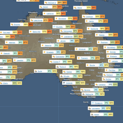
Townsville
Max 29°C. Sunny. Rain: 0%. S winds 25-35 km/h, becoming light in evening.
Herbert and Lower Burdekin
Max 28°C. Sunny. Rain: 0%. S winds 25-35 km/h, becoming light in evening.
North Tropical Coast and Tablelands
Max 29°C. Sunny. Rain: 0%. Possible AM fog. S-SE winds 15-20 km/h, shifting E-SE 15-25 km/h AM.
Cairns
Max 28°C. Sunny. Rain: 5%. Sunny. S winds 15-20 km/h, shifting SE 20-25 km/h AM, then light in evening.
Mackay
Max 25°C. Sunny. Rain: 0%. Sunny. S winds 15-25 km/h, shifting SE midday, then light in evening.
Northern Goldfields
Max 26°C. Sunny. Rain: 0%. S-SE winds 25-35 km/h.
Mt Isa
Max 25°C. Sunny. Rain: 0%. Sunny. SE winds 20-30 km/h, becoming light in evening.
Click here to support to Wally's Weather
National maps by Weatherzone (weatherzone.com.au)
State maps by Windy (Windy.com)
Weather forecast supplemented by Bureau of Meteorology (bom.gov.au)
Rainfall daily totals (https://meteologix.com/ )
Wally's Weather provides professionally researched data and information. Andrew aka 'Wally' has over 20 years of experience in meteorology research and data analysis. The content here is provided as educational information aimed at providing the community and businesses with the tools required to determine local-based forecasts. IMPORTANT: The forecasts and information posted should never be used on their own to make business decisions as local influences.


Comments