Morning Weather - December 10 - Wally's Weather Australia
- Dec 9, 2023
- 6 min read
This weather update is brought to you by Genesis Electrical NQ

Genesis Electrical NQ
We can Solve all of your Electrical, Air Conditioning and Solar needs!
Green Energy Initiative
Phone: 1300 443 637
Email: info@genesislec.com
Wally is SUNDAY at 11am at Gecko Interiors, a shop that has fun, colourful, quirky gifts like Wally's new board game Dam Filler! He is passionate about education and would love for you to have your very own slice of Townsville history. Learn all about the dome, basic maths, geography, weather and other STEM topics.

Special report
Monsoon:
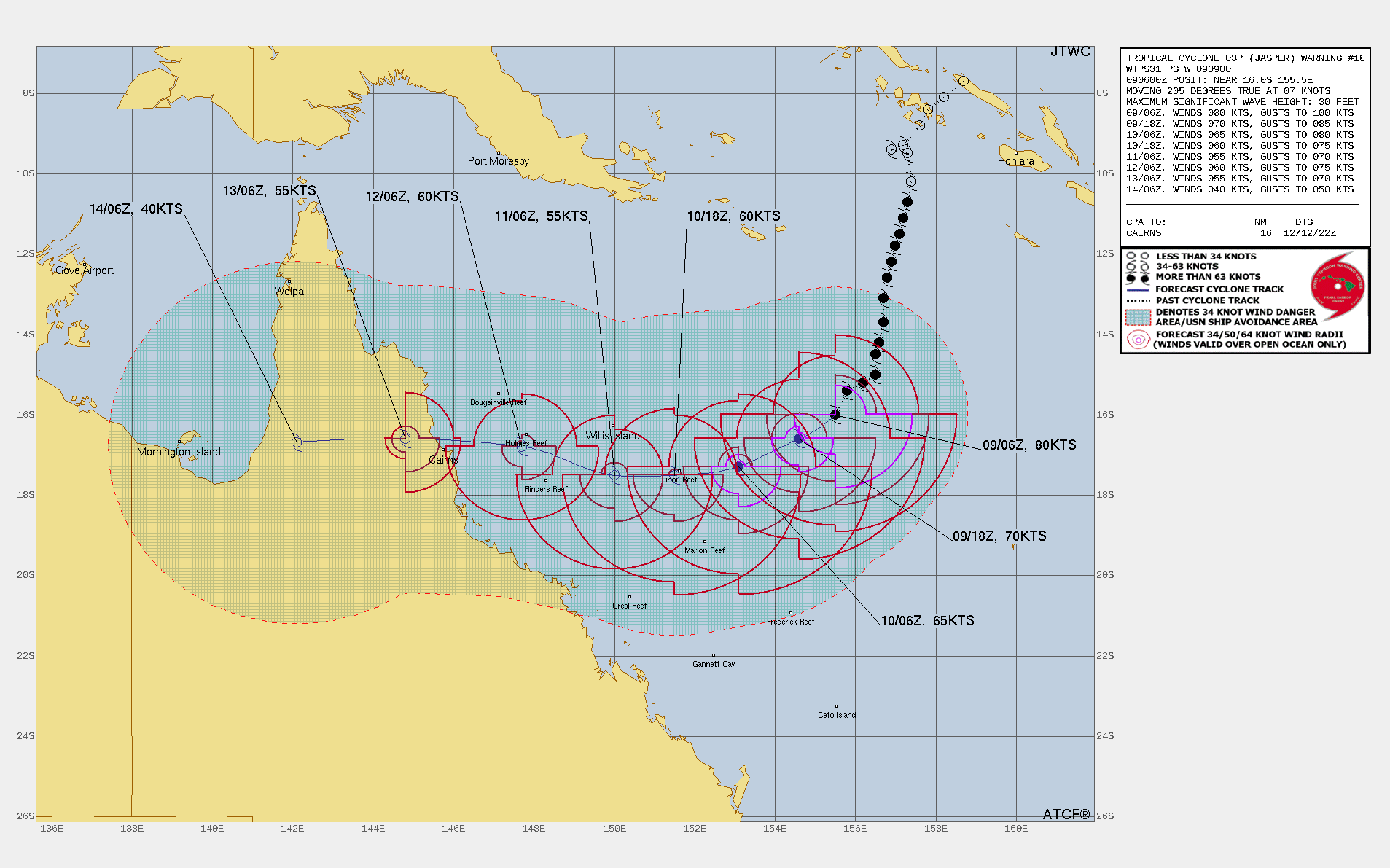
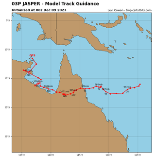
Severe Tropical Cyclone 03P (Jasper), located approximately 561 nautical miles (about 1,039 kilometers) east of Cairns, Australia, has been tracking south-southwestward at a speed of 7 knots over the past six hours. As of 4:00 PM, the minimum central pressure is 970 hPa, and the maximum significant wave height recorded at the same time is 30 feet. The system is weakening and upper levels of cloud covering the visible circulation. I included the GFS long-range forecast to provide an idea of where it will go after it crosses, only because this is a very common path. However I am not confident the ridge will push the system as far North as currently expected.
Storms:
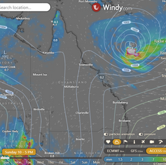
A trough will deepen, bringing heat and storms to NSW and western QLD, with heavy rain increasing in SA. Dry and gusty easterly winds are expected for WA's west. Tropical Cyclone Jasper is forecasted to continue tracking toward the QLD coast, keeping intense wind, rain, and waves well offshore.
Warnings
Damaging winds and heavy rainfall are issued for parts of Gosford/Wyong area, Mid North Coast, and Hunter.
Strong Wind Warnings are in place for Ningaloo, Gascoyne, Geraldton, Lancelin, Bunbury Geographe, Leeuwin coasts, and Sunday warnings for Townsville, Mackay, Capricornia, West Coast, and Far North West and Lower East coasts.
Fire Weather Warnings for various regions, including Burrup, Midwest Coast, Swan Inland North, Swan Inland South, and Brockman.
Sheep Graziers Warnings for North West Pastoral, E Eyre, L Eyre, Yorke Peninsula, Mount Lofty Ranges, Kangaroo Island, West Coast, and Central.
Severe Weather Warning for heavy rainfall in Lower Eyre Peninsula, Eastern Eyre Peninsula, West Coast, North West Pastoral districts.
Storm Force Wind Warning for Western, Southeastern, and Southern Areas.
Gale Warning for Sydney Enclosed Waters & Sydney & Illawarra coasts, with Strong Wind Warnings for Coffs, Macquarie, Hunter, Batemans & Eden coasts.
Downy Mildew Advice for Mid North, Mount Lofty Ranges, Riverland, Murraylands, Upper South East, and Lower South East.
Flood Watch For The Mt Lofty Ranges, Mid North, And Eyre Peninsula.
Final Flood Warning For The Latrobe River and Minor Flood Warning For The Thomson River.
Fire Weather Warning for Greater Sydney Region, Lower Central West Plains, Southern Slopes, and Northern Riverina.
Minor Flood Warnings for the Paroo River (Qld), Barcoo River, and Paroo River (Nsw).
Storm probabilities 2PM | Rain Accumulation 3 days | Rain 8 x 24 hour accumulated | BOM Tracking


National
Severe Tropical Cyclone Jasper will soon head west towards north Queensland, possibly reaching the Gulf of Carpentaria. A ridge will persist due to various weather systems, with a trough moving southwest and then east over Queensland.


State
Tropical Cyclone Jasper in Coral Sea to move west towards north Queensland coast next week. Possible move into Gulf of Carpentaria late in week. Ridge maintained by highs near New Zealand and Tasman Sea. Trough in southwest on Sunday, deepening on Wednesday and moving east over central and southern Queensland late next week.


4-day
Sunday: Isolated showers and thunderstorms in northwest and northern Cape York Peninsula. Chance of a shower or thunderstorm in southern Darling Downs and Granite Belt. Isolated showers on east coast north of Mackay. Mostly clear elsewhere. Light to moderate northeast to southeasterly winds, fresh at times on east coast north of Gladstone. Moderate to fresh north to northeasterly winds in southwest. Winds turning north to northwesterly in Gulf Country.
Monday: Some showers and thunderstorms in certain districts. Sunny in the south, partly cloudy elsewhere. Strong winds and seas along the east coast. Heatwave in the north and northwest. Above average temperatures in the south and northeast, near average elsewhere.
Tuesday: Tuesday's weather forecast: Showers in the east from Cooktown to St Lawrence, with isolated showers in other areas except the southeast. Thunderstorms possible in the northwest and Cape York Peninsula west of Coen. Chance of a thunderstorm in the far southwest. Partly cloudy in the southeast. Wind and seas increasing along the east coast, subject to the movement of Severe Tropical Cyclone Jasper. Severe heatwave conditions in the far north and northwest. Above-average temperatures in the southern interior, northwest, and far northeast, and near average elsewhere.
Wednesday: Expect showers, rain, and a chance of thunderstorms with heavy falls in eastern districts. Isolated to scattered showers are possible in other areas, with isolated thunderstorms in the north and northwest. There is also a chance of a thunderstorm in the southwest. Watch out for damaging winds and a coastal storm surge in the Cape Melville to Townsville region due to Severe Tropical Cyclone Jasper. Partly cloudy in the southeast. Severe heatwave conditions in the northwest. Temperatures will be above average in the west and southern interior, below average in the northeast, and near average elsewhere.


North Tropical Coast and Tablelands:
Max temperature: 30 to 37, Min temperature: 17 to 23, Wind speed: 15 to 20 km/h, Wind direction: east to southeasterly, Rainfall: slight chance of shower in the south, Partly cloudy.
Herbert and Lower Burdekin:
Max temperature: low to mid 30s, Min temperature: 19-22, Wind speed: light winds becoming east to northeast 20-30 km/h, Wind direction: easterly, Rainfall: slight chance of shower along coastal fringe, near zero chance elsewhere
Central Coast and Whitsundays:
Max temperature: 36, Min temperature: 19, Wind speed: 25-35 km/h from the east to southeasterly direction, Rainfall: Partly cloudy, Medium chance of showers near the coast, slight chance elsewhere
Peninsula:
Max temperature: 39, Min temperature: mid 20s, Wind speed: 15 to 25 km/h, Wind direction: southeast to southwesterly, Rainfall: Chance of showers, Mostly sunny but chance of thunderstorm at night.
Gulf Country:
The weather will be mostly sunny with a medium chance of showers in the morning, light winds becoming northwest to northeasterly 15 to 25 km/h, and temperatures ranging from mid to high 20s overnight to around 40 degrees during the day.
Northern Goldfields and Upper Flinders:
Max temperature: 35-40; Min temperature: 19-24; Wind speed: 15-25 km/h; Wind direction: East to northeasterly; Rainfall: Sunny
Capricornia:
Max temperature of 30 to 35, min temperature of 18 to 23, wind speed of 25 to 40 km/h, wind direction easterly, slight chance of a shower near the coast, near zero chance elsewhere, partly cloudy with falling overnight temperatures.
Central Highlands and Coalfields:
Max temperature: low to mid 30s, Min temperature: 17-21, Wind speed: 25-35 km/h easterly, Wind direction: easterly, Rainfall: none, Other: Mostly sunny with overnight temperatures falling.
Central West:
Max temperature: 41 Min temperature: 20 Wind speed: 35 Wind direction: East to northeasterly Rainfall: None Sunny
North West:
Max temperature: low 40s, Min temperature: mid to high 20s, Wind speed: 15-35 km/h, Wind direction: east to northeasterly, Rainfall: none, Other: Sunny.
Channel Country:
The max temperature is in the low to mid 40s with northeasterly winds 20 to 30 km/h, Chance of raised dust in the northwest in the evening, with overnight temperatures falling to the mid to high 20s.
Maranoa and Warrego:
Max temperature: 36 to 42, Min temperature: 20 to 28, Wind speed: 25 to 35 km/h from the northeast, Rainfall: None, Other: Sunny.
Darling Downs and Granite Belt:
Max temperature: 37, Min temperature: 16, Wind speed: 35 km/h, Wind direction: east to northeasterly, Rainfall: Sunny
Wide Bay and Burnett:
The weather will be partly cloudy with easterly winds at 25-35 km/h and temperatures ranging from 17-22°C overnight to low-mid 30s°C during the day.
Southeast Coast:
Maximum temperature: 30, Minimum temperature: 17, Wind speed: 20-30 km/h easterly, Wind direction: easterly, Rainfall: none, Other: Partly cloudy with overnight temperatures falling.
Click here to support to Wally's Weather
National maps by Weatherzone (weatherzone.com.au)
State maps by Windy (Windy.com)
Weather forecast supplemented by Bureau of Meteorology (bom.gov.au)
Rainfall daily totals (https://meteologix.com/ )
AccuWeather (https://www.accuweather.com/)
Nine Weather (https://www.9news.com.au/weather)
Wally's Weather provides professionally researched data and information. Andrew aka 'Wally' has over 20 years of experience in meteorology research and data analysis. In 2023 finished top 4 for the AMOS national weather forecasting competition. The content here is provided as educational information aimed at providing the community and businesses with the tools required to determine local-based forecasts. IMPORTANT: The forecasts and information posted should never be used on their own to make business decisions as local influences.


Comments