Morning Weather - December 16 - Wally's Weather Australia
- Dec 15, 2023
- 6 min read
This weather update is brought to you by Genesis Electrical NQ

Genesis Electrical NQ
We can Solve all of your Electrical, Air Conditioning and Solar needs!
Green Energy Initiative
Phone: 1300 443 637
Email: info@genesislec.com
Special report
Monsoon:
Ex Tropical Cyclone 03P (Jasper) is slowly edging itself into the gulf over the next 2 to 4 days. The rain is expected to be light close to Mornington Island but will keep an eye on it because the rain has increased further North near Weipa. There are loads of models showing all sorts and the Gulf is notoriously difficult to forecast. It may go back, and that has happened before, but I've seen a lot of systems in the Gulf and while there are some common movements, you can't tell too far ahead. The BOM has struggled to forecast these system 24 hours ahead.


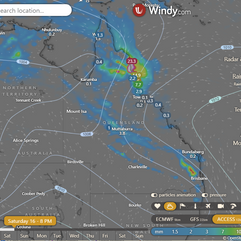
Movement of ex TC Jasper over 4 days
Storms:
A tropical low (ex-Tropical Cyclone Jasper) will bring heavy rain, storms, and strong winds to north QLD. Troughs will maintain heat and generate showers and storms in the NT and QLD.
A front and trough should bring showers to TAS. Highs will keep much of the country's south dry.
WEATHER WARNINGS
Moderate Flood Warning For The Barron River.
Fire Weather Warning for Midwest Coast and Midwest Inland.
Strong Wind Warning for Perth Local Waters & Gascoyne, Geraldton, Perth, Bunbury Geographe & Leeuwin coasts. Cancelled Lancelin Coast.
Severe Weather Warning (Locally Intense Rain & Winds) North Tropical Cst & Tablelands & Peninsula, G Country & Nthn Goldfields & UFlinders.
Minor Flood Warning For The Tully River And Flood Warning For The Murray River.
Strong Wind Warning for Sydney Enclosed Waters & Byron, Sydney, Illawarra, Batemans, and Eden coasts.
Strong Wind Warning for Central, Central Gippsland and East Gippsland coasts.
Strong Wind Warning for Friday for Lower South East Coast.
Gale Warning South East Coast. Strong Wind Warning Banks Strait & Franklin Sound, East of Flinders Is & CN, Lower East & South West coasts.
Major Flood Warning For The Daintree And Flood Warning For The Mossman River.
Flood Watch For Parts Of The North Tropical Coast And Parts Of The Cape York Peninsula.
Fire Weather Warning for Greater Hunter and Greater Sydney Region.
Final Flood Warning For The Paroo River (Qld).
Minor Flood Warning For The Paroo River (Nsw).


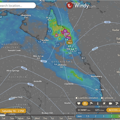
Storms 2PM maturing
National
Ex-Tropical Cyclone Jasper slowly moves west over Cape York Peninsula towards the Gulf of Carpentaria on Sunday, then northwest. A weak ridge is over the east coast. Broad trough and upper trough enhance showers and thunderstorms in central and southern Queensland. High moves into Tasman Sea, extending ridge over state. New trough moves into central and southern Queensland, moves east slowly, weakens as new high moves into southern Tasman Sea.


Synoptic | Temp/Rain | Wind | Sea Surface Temp
State
Ex-Tropical Cyclone Jasper slowly moves west across Cape York Peninsula, reaches Gulf of Carpentaria, then moves northwest. Weak ridge over east coast. Broad trough over central and southern Queensland persists. Upper trough may enhance showers and thunderstorms in southern Queensland on weekend. High moves into Tasman Sea on Monday, extending ridge over state. New trough moves into central and southern Queensland on Tuesday, moving east slowly over following days, weakening as new high moves into southern Tasman Sea.


ACCESS 3Hour Rainfall
4-day
Saturday: Possible showers, rain, and storms in Cape York Peninsula and North Tropical Coast with heavy rain possible. Showers and storms elsewhere, except southwest. Severe storms with heavy rain, winds, and hail in central and southeastern Queensland. Clear in southwest. Winds shifting in western and southern interior. Heatwave in southeast.
Sunday: Scattered showers, rain, and thunderstorms in Cape York Peninsula and North Tropical Coast, with heavy falls in southwest. Showers and thunderstorms elsewhere, except southwest. Severe thunderstorms, heavy rainfall, damaging winds, and hail in central and southeastern Queensland. Mostly sunny in southwest. Severe heatwave in southeast. Above average temperatures in south, eastern districts, and far west, well above average in southeast. Below average temperatures elsewhere.
Monday: Expect showers and thunderstorms in most areas, except for the southwest, Central Coast, and Central West District. Showers may become widespread at times north of Kowanyama. The southwest will be mostly sunny. There may be morning fog in the southeast. Temperatures will be above average to the south of Hughenden and below average everywhere else.
Tuesday: Showers and thunderstorms spread across the state, with mainly showers in eastern districts south of Port Douglas. Above-average temperatures in the south of Hughenden and below-average elsewhere.


North Tropical Coast and Tablelands:
Max temperature: 28, Min temperature: low 20s, Wind speed: 15 to 25 km/h, Wind direction: east to northeasterly, Rainfall: Very high chance of rain, Cloudy, Chance of thunderstorm, Heavy falls possible north of Cairns.
Herbert and Lower Burdekin:
Max temperature: mid to high 20s, Min temperature: low to mid 20s, Wind speed: Light becoming northeasterly 15 to 20 km/h, Wind direction: Northeasterly, Rainfall: Very high chance of rain, Other: Cloudy with light winds.
Central Coast and Whitsundays:
Max temperature: 30, Min temperature: low 20s, Wind speed: light winds becoming north to northeasterly 15 to 25 km/h, Wind direction: becoming light in the evening, Rainfall: slight chance of showers, Other: Cloudy with overnight temperatures falling to the low 20s.
Peninsula:
Max temperature is around 30°C, min temperature is in the low to mid 20s°C, wind speed is 15-25 km/h from east to northeast, wind direction shifts from northwest to northeast, there is a very high chance of rain with a possibility of a severe thunderstorm and heavy falls are possible south of Coen, and the weather will be cloudy.
Gulf Country:
Max temperature: 41, Min temperature: mid to high 20s, Wind speed: 25-35 km/h easterly, Wind direction: easterly, Rainfall: Very high chance of showers in the north, medium chance elsewhere, Other: Partly cloudy, chance of severe thunderstorm in northeast, heavy falls possible in northeast.
Northern Goldfields and Upper Flinders:
The weather will be cloudy with a high chance of rain, thunderstorms, and heavy falls possible in the north; wind speed will be 20-30 km/h from the east/northeast; temperatures will range from low to mid 20s overnight to 27-38 during the day.
Capricornia:
Max temperature: 31-36, Min temperature: low to mid 20s, Wind speed: light to northerly 20-30 km/h, Wind direction: northerly, Rainfall: partly cloudy with medium chance of showers in the south, slight chance elsewhere, Other: chance of thunderstorms in late morning, possibly severe in the far south. Light winds becoming northerly in the morning, then becoming light in the late evening.
Central Highlands and Coalfields:
Max temperature: 30 to 36, Min temperature: low 20s, Wind speed: light, Wind direction: northerly 15 to 20 km/h, Rainfall: High chance of showers, Thunderstorm chance: possibly severe.
Central West:
Max temperature: 33-39; Min temperature: low to mid 20s; Wind speed: north-east 15-25 km/h; Wind direction: north-east; Rainfall: partly cloudy with medium chance of showers; Other: chance of thunderstorm in the afternoon and evening.
North West:
Max temperature: 40, min temperature: mid 20s, wind speed: 20 to 30 km/h, wind direction: northeast to southeasterly, rainfall: slight chance of shower east of Mt Isa, near zero chance of rain elsewhere, other: mostly sunny, chance of thunderstorm from late morning.
Channel Country:
Max temperature: 40, Min temperature: low to mid 20s, Wind speed: 25 to 40 km/h, Wind direction: South to southeasterly, Rainfall: N/A, Other: Sunny.
Maranoa and Warrego:
Max temperature: mid to high 30s; Min temperature: low to mid 20s; Wind speed: light, then 15-25 km/h; Wind direction: N to NW, then S to SW; Rainfall: Slight chance of shower, thunderstorm in north
Darling Downs and Granite Belt:
Max temperature: 34 to 39, Min temperature: 19 to 24, Wind speed: 15 to 25 km/h, Wind direction: north to northwesterly, Rainfall: Slight chance of a shower, other: Partly cloudy with a chance of thunderstorms.
Wide Bay and Burnett:
Max temperature: low to mid 30s, Min temperature: low 20s, Wind speed: light winds becoming northwesterly 15 to 25 km/h in the morning then tending northerly in the early afternoon, Wind direction: northwesterly in the morning then northerly, Rainfall: high chance of showers most likely in the afternoon and evening, Other weather conditions: partly cloudy with a chance of severe thunderstorms.
Southeast Coast:
Max temperature: 37, Min temperature: low 20s, Wind speed: light winds becoming 15-25 km/h, Wind direction: north to northwesterly, Rainfall: High chance of showers, Chance of thunderstorm, Partly cloudy.
Click here to support to Wally's Weather
National maps by Weatherzone (weatherzone.com.au)
State maps by Windy (Windy.com)
Weather forecast supplemented by Bureau of Meteorology (bom.gov.au)
Rainfall daily totals (https://meteologix.com/ )
AccuWeather (https://www.accuweather.com/)
Nine Weather (https://www.9news.com.au/weather)
Wally's Weather provides professionally researched data and information. Andrew aka 'Wally' has over 20 years of experience in meteorology research and data analysis. In 2023 finished top 4 for the AMOS national weather forecasting competition. The content here is provided as educational information aimed at providing the community and businesses with the tools required to determine local-based forecasts. IMPORTANT: The forecasts and information posted should never be used on their own to make business decisions as local influences.


Comments