Morning Weather - December 18 - Wally's Weather Australia
- Dec 17, 2023
- 5 min read
This weather update is brought to you by Genesis Electrical NQ

Genesis Electrical NQ
We can Solve all of your Electrical, Air Conditioning and Solar needs!
Green Energy Initiative
Phone: 1300 443 637
Email: info@genesislec.com
Special report
Monsoon:
Ex Tropical Cyclone 03P (Jasper) is expected to merge with another low over the NT, and form a trough. That trough should cross the coast and slowly shift North briefly. From there it will produce rain along the length of the trough but it will be confined mainly to the trough.

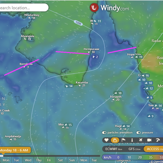


Merging of lows into a low pressure trough
Storms:
Troughs, a tropical low, and moist winds will bring showers and storms to the NT Top End and QLD. A front and trough are expected to trigger showers and storms over western NSW, western VIC, eastern & central SA, and TAS. A trough in the west will draw heat from the interior into WA's west.
WEATHER WARNINGS
Severe Storm Warning (To Intense Rain, Winds & Hail) for North Tropical Cst & Tablelands, Capricornia, Wide Bay & Burnett & Darling Downs.
Major Flood Warning For The Daintree River And Flood Warning For The Mossman River.
Severe Thunderstorm Warning (Damaging Winds) for parts of Eucla and South Interior districts.
Severe Thunderstorm Warning - SE Queensland (Winds, Hail & Heavy Rain) for South Burnett, Toowoomba, Southern Downs & Western Downs Council.
Major Flood Warning For The Tully And Murray Rivers.
Severe Thunderstorm Warning (Damaging Winds) for parts of West Coast and North West Pastoral districts.
Major Flood Warning For The Barron River.
Major Flood Warning For The Johnstone River Catchment.
Strong Wind Warning for Pilbara Coast East, Perth Local Waters & Geraldton, Lancelin, Perth, Bunbury Geographe, Leeuwin, and Eucla coasts.
Fire Weather Warning for Swan Inland South, Capes, and Blackwood.
Major Flood Warning For The Mulgrave River And Flood Warning For The Russell River.
Severe Weather Warning (Heavy, Locally Intense Rain) for Peninsula, G Country, North Tropical Coast & Tablelands & Nthn Goldfields & UFlinders.
Major Flood Warning For The Herbert River.
Flood Watch For Parts Of The Cape York Peninsula And Parts Of Gulf Country.
Strong Wind Warning for Cooktown and Cairns coasts.
Strong Wind Warning for Far West Coast.
Strong Wind Warning for Monday for Coffs, Macquarie and Hunter coasts.
Strong Wind Warning for South East and South West coasts.
Fire Weather Warning for Burrup and South Interior.
Minor Flood Warning For The Paroo River (Nsw).

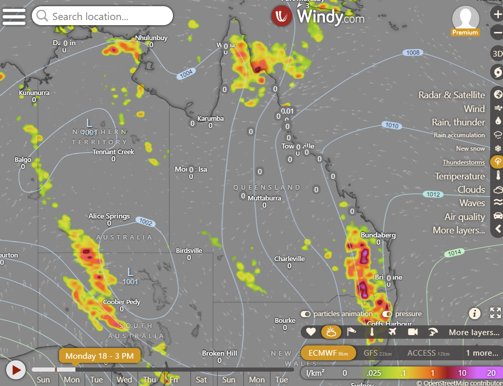
Storms 2PM maturing
National
Ex-Tropical Cyclone Jasper lingers on Cape York Peninsula, causing heavy rain. It might move to the Gulf of Carpentaria by late Monday. A ridge covers the east coast while a trough affects southeast Queensland.


Synoptic | Temp/Rain | Wind | Sea Surface Temp
State
Ex-Tropical Cyclone Jasper on Cape York Peninsula is slowly moving with heavy rainfall, uncertainty about its path but likely to move to Gulf of Carpentaria on Monday or Tuesday. Rest of east coast has weak ridge, while northwest-southeast trough brings unsettled conditions.


ACCESS 3Hour Rainfall
4-day
Monday: Showers, rain, and thunderstorms in Cape York Peninsula and North Tropical Coast, with heavy falls. Showers and thunderstorms elsewhere, except southwest. Severe thunderstorms possible with heavy rain, strong winds, and hail in central and southeast Queensland. Clear in the far southwest. Winds from northwest to northeast, turning southeast to southwest in western and southern Queensland. Severe heatwave in the southeast.
Tuesday: Scattered showers, mainly in eastern districts south of Port Douglas. Widespread showers at times north of Kowanyama. Severe thunderstorms possible with strong winds south of Mount Isa. Above average temperatures south of Hughenden, below average elsewhere.
Wednesday: Possible showers and thunderstorms across the state, more likely to be showers only between Cooktown and Rockhampton. Showers could become widespread at times in far northern Cape York Peninsula and the southern interior. Potential for severe thunderstorms in the central and southern interior, south of Moranbah and west of Goondiwindi. Above average temperatures in eastern districts south of Mackay, below average elsewhere.
Thursday: Showers and thunderstorms across the state, mainly showers in Cooktown to St Lawrence. Partly cloudy in the southwest. Temperatures below average in the south and far north, near average everywhere else.


North Tropical Coast and Tablelands:
Max temperature: low to high 20s, Min temperature: 19-23, Wind speed: 20-30 km/h easterly, Wind direction: easterly, Rainfall: Cloudy, very high chance of rain in the morning, chance of thunderstorm, heavy falls in the north.
Herbert and Lower Burdekin:
Max temperature: 30, Min temperature: low 20s, Wind speed: east to northeasterly 20 to 30 km/h becoming light in the late evening, Wind direction: east to northeasterly, Rainfall: Partly cloudy with medium chance of showers in the north and slight chance elsewhere, Other: Overnight temperatures falling to low 20s with daytime temperatures reaching around 30.
Central Coast and Whitsundays:
Max temperature: low to mid 30s, Min temperature: low 20s, Wind speed: light winds becoming northeasterly 20 to 30 km/h in the morning then becoming light in the late evening, Wind direction: northeasterly, Rainfall: None, Other: Mostly sunny with overnight temperatures falling to the low 20s.
Peninsula:
Max temperature: 34°C, Min temperature: Low to mid 20s, Wind speed: 15-30 km/h, Wind direction: Northeast to east, Rainfall: Very high chance of rain with heavy falls possible south of Coen, Other: Cloudy with chance of thunderstorm.
Gulf Country:
The summary is: Maximum temperature of 39°C, minimum temperature in the low to mid 20s°C, winds northeast to southeasterly at 25 to 35 km/h, partly cloudy with a chance of thunderstorms and heavy rain possible in the north, overnight temperatures falling and reaching a daytime high of 29 to 39°C.
Northern Goldfields and Upper Flinders:
Max temperature: 36, Min temperature: 19, Wind speed: increasing from 15-35 km/h, Wind direction: east to northeasterly, Rainfall: partly cloudy with showers likely in the north, near zero chance elsewhere, Other: chance of a thunderstorm.
Capricornia:
Max temperature: 31 to 36, Min temperature: low 20s, Wind speed: light winds becoming northeasterly 20 to 30 km/h in the morning then becoming light in the late evening, Wind direction: northeasterly, Rainfall: partly cloudy with medium chance of showers in the south and slight chance elsewhere, Other: chance of a thunderstorm.
Central Highlands and Coalfields:
Maximum temperature: low to mid 30s, minimum temperature: 19 to 22, wind speed: 20 to 30 km/h, wind direction: northeasterly, slight chance of a shower and thunderstorm in the southeast, mostly sunny with light winds.
Central West:
Max temperature is 35 to 40°C, min temperature is low to mid 20s, wind speed is 20 to 30 km/h from the northeast, and it is sunny with no mention of rainfall.
North West:
Max temperature: 41, Min temperature: 20s, Wind speed: 25-35 km/h, Wind direction: E-NE, Rainfall: None, Other: Sunny morning, chance of thunderstorm in afternoon/evening.
Channel Country:
Max temperature: Low to mid 40s, Min temperature: 22 to 28, Wind speed: 15 to 30 km/h, Wind direction: Northeast to southeasterly, Rainfall: Sunny day with chance of thunderstorm in late afternoon and evening.
Maranoa and Warrego:
Max temperature: 41, Min temperature: 19, Wind speed: 15-25 km/h, Wind direction: N-NW, Rainfall: Slight chance of a shower, Mostly sunny with a chance of thunderstorm in the evening.
Darling Downs and Granite Belt:
Max temperature: 33 to 39, Min temperature: low 20s, Wind speed: 15 to 20 km/h becoming 20 to 30 km/h, Wind direction: north to northeasterly, Rainfall: Partly cloudy with medium chance of showers in the far east and slight chance elsewhere, Other: Chance of thunderstorm in late morning.
Wide Bay and Burnett:
Max temperature: low to mid 30s, Min temperature: 19-23, Wind speed: light winds becoming northeasterly 15-20 km/h, Wind direction: northeasterly, Rainfall: medium chance of showers, most likely in late morning and afternoon, Other: partly cloudy, chance of a thunderstorm.
Southeast Coast:
Max temperature: low 30s, Min temperature: low 20s, Wind speed: light, Wind direction: northeasterly, Rainfall: medium chance of showers, Other: partly cloudy with a chance of thunderstorm.
Click here to support to Wally's Weather
National maps by Weatherzone (weatherzone.com.au)
State maps by Windy (Windy.com)
Weather forecast supplemented by Bureau of Meteorology (bom.gov.au)
Rainfall daily totals (https://meteologix.com/ )
AccuWeather (https://www.accuweather.com/)
Nine Weather (https://www.9news.com.au/weather)
Wally's Weather provides professionally researched data and information. Andrew aka 'Wally' has over 20 years of experience in meteorology research and data analysis. In 2023 finished top 4 for the AMOS national weather forecasting competition. The content here is provided as educational information aimed at providing the community and businesses with the tools required to determine local-based forecasts. IMPORTANT: The forecasts and information posted should never be used on their own to make business decisions as local influences.


Comments