Morning Weather - December 19 - Wally's Weather Australia
- Dec 18, 2023
- 6 min read
This weather update is brought to you by Genesis Electrical NQ

Genesis Electrical NQ
We can Solve all of your Electrical, Air Conditioning and Solar needs!
Phone: 1300 443 637
Email: info@genesislec.com

your
2024 Wally's Weather Calendar
today.
If you found the information here helpful, then help us to continue.
Special report
Christmas:
Normally I don't look too far ahead but it's Christmas and well, let's just do it. A low-pressure (L) system is expected to dominate the weather over the nation on Christmas day, centring over the NT. The High pressure system (H) South of SA combined with the low over NT High-pressure should provide some windy conditions over the Southern Australia coastline.
The low combining with a low pressure (L) trough (pink dashed line) reaching down into QLD and crossing the SEQ coast should provide more stormy weather conditions. Mainly over the dividing ranges. Positioning will likely vary greatly given it is 7 days away, but we are getting a good feel for what to expect. For most of the East coast scattered showers later in the evening are possible from storms drifting to the coast.low-pressure.


Merging of lows into a low pressure trough
Storms:
Troughs, a tropical low, and moist winds expected to bring rain, showers, and storms to the NT Top End & far north QLD. Other troughs and a front are likely to trigger showers and storms across QLD, NSW, eastern VIC & TAS. Onshore winds could bring a few showers to WA's south.
WEATHER WARNINGS
Severe Thunderstorm Warning - Southeast Queensland (Damaging Winds, Large Hail & Heavy Rainfall) for Western Downs & Toowoomba Council Areas.
Severe Storm Warning (Rain, Winds & Hail) for Peninsula, North Tropical Cst & Tablelands, C Highlands & Coalfields, Wide Bay & Burnett, Maranoa.
Severe Thunderstorm Warning (Damaging Winds) for parts of North West Pastoral and North East Pastoral districts.
Severe Weather Warning (Damaging Winds) for parts of Lower West and South West districts.
Strong Wind Warning for Perth Local Waters & Geraldton, Lancelin, Perth, Bunbury Geographe, and Leeuwin coasts.
Fire Weather Warning for Midwest Coast, Midwest Inland, Lesueur, Yarra Yarra, and Mortlock.
Moderate Flood Warning For The Herbert River.
Moderate Flood Warning For The Daintree River And Flood Warning For The Mossman River.
Minor Flood Warning For The Barron River.
Major Flood Warning For The Murray River And Moderate Flood Warning For The Tully River.
Final Flood Warning For The Mulgrave River And Flood Warning For The Russell River.
Strong Wind Warning for Tuesday for Port Phillip, Western Port & Central, Central Gippsland and East Gippsland coasts.
Strong Wind Warning for Spencer Gulf and Gulf St Vincent.
Strong Wind Warning Tuesday East of Flinders Is & Far NW, CN, Upper East & Lower E Coasts.
Strong Wind Warning for Coffs, Macquarie and Hunter coasts
Flood Watch For Parts Of The Cape York Peninsula.
Final Flood Warning For The Paroo River (Nsw).
Final Flood Warning For The Johnstone River Catchment.
Fire Weather Warning for Swan Inland South, Capes, and Blackwood.


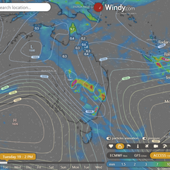
Storms 2PM maturing
National
Ex-Tropical Cyclone Jasper on Cape York Peninsula will likely move into the Gulf of Carpentaria overnight. Rain off Cooktown extends east before weakening. Ridge over the east coast from a high near New Zealand. Unsettled conditions from a trough stretching from northwest to southeast Queensland, moving inland today then east later.


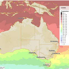
Synoptic | Temp/Rain | Wind | Sea Surface Temp
State
Ex-tropical cyclone Jasper is moving towards the Gulf of Carpentaria from Cape York Peninsula. A trough with heavy rain extends from the low into Cooktown, moving north along the coast. A weak ridge covers the east coast from near New Zealand. A trough moves from northwest to southeast Queensland, causing unsettled conditions before moving inland and then back to the east later in the week.


ACCESS 3Hour Rainfall
4-day
Tuesday: Scattered to widespread showers, rain, and isolated thunderstorms with heavy falls possible in Cape York Peninsula and northern North Tropical Coast. Isolated showers for remaining coastal areas north of Proserpine. Isolated showers and thunderstorms mainly inland through southern and Central Queensland, possibly severe. Partly cloudy elsewhere with light to moderate east to northeasterly winds. Maximum temperatures above average south of Hughenden, below average elsewhere.
Wednesday: Isolated showers and thunderstorms across the state, mainly showers between Cooktown and Rockhampton. Scattered showers at times over far northern Cape York Peninsula and southern interior. Potential for severe thunderstorms in central and southern interior, below average temperatures in the southwest.
Thursday: Isolated showers and thunderstorms across the state, showers only between Cooktown and St Lawrence. Scattered to widespread showers in southeastern and central Queensland, northern Peninsula and Torres Strait. Partly cloudy in the far southwest. Below average temperatures in the southern interior.
Friday: Some showers and storms across the state, potentially heavy in the southeast. Sunny in the far west. Below-average max temperatures in the southern interior and southeast. Above-average max temperatures in the far west, spreading to the east coast Sunday.


North Tropical Coast and Tablelands:
Max temperature: mid to high 20s, Min temperature: 19-23, Wind speed: easterly 15-25 km/h, Wind direction: easterly, Rainfall: high chance of showers near coast, medium chance elsewhere, Other: partly cloudy, chance of thunderstorm in the north, overnight temperatures falling.
Herbert and Lower Burdekin:
The weather will be partly cloudy with a slight chance of a shower, light winds becoming east to northeasterly at 15 to 20 km/h in the morning, then becoming light in the evening. The maximum temperature during the day will reach 28 to 33 degrees, with overnight temperatures falling to the low 20s.
Central Coast and Whitsundays:
The weather will be partly cloudy with temperatures ranging from 19 to 35, light winds becoming east to northeasterly at 15-25 km/h in the morning and rainfall with a slight chance of a shower.
Peninsula:
Max temperature: 30°C, Min temperature: low to mid 20s, Wind speed: easterly 20-30 km/h becoming light, Wind direction: east, Rainfall: Very high chance of showers, Chance of thunderstorm: likely severe, Overnight temperatures: low to mid 20s, Daytime temperatures: around 30°C.
Gulf Country:
Max temperature: 33 to 39, Min temperature: low to mid 20s, Wind speed: east to northeasterly 20 to 30 km/h, Wind direction: north to northeasterly 15 to 20 km/h, Rainfall: Partly cloudy with medium chance of showers in the north, most likely in the afternoon and evening and near zero chance of rain elsewhere, Other: chance of a thunderstorm.
Northern Goldfields and Upper Flinders:
Max temperature: 30 to 38, Min temperature: 18 to 23, Wind speed: 15 to 25 km/h from east to northeasterly, Chance of showers in the north, Mostly sunny.
Capricornia:
The weather tomorrow will have a maximum temperature of 31 to 36 degrees, a minimum temperature in the low 20s, light winds becoming east to northeasterly 15 to 25 km/h in the morning and then becoming light in the late evening, a slight chance of a shower, and mostly sunny conditions throughout the day.
Central Highlands and Coalfields:
Max temperature: low to mid 30s, min temperature: low 20s, wind speed: light, wind direction: northeasterly, rainfall: medium chance of showers, weather: mostly sunny with a chance of thunderstorm in the south in the afternoon and evening.
Central West:
Max temperature: 35 to 40, Min temperature: low to mid 20s, Wind speed: 20 to 30 km/h northeasterly, Wind direction: northeasterly, Rainfall: slight chance of a shower, Other: Mostly sunny, chance of a thunderstorm in the late afternoon and evening.
North West:
Max temperature: 40, Min temperature: low to mid 20s, Wind speed: 20 to 30 km/h becoming light, Wind direction: northeasterly, Rainfall: slight chance of a shower, Other: Sunny morning, chance of thunderstorm in afternoon and evening.
Channel Country:
Max temperature: 40, Min temperature: 24, Wind speed: 20-40 km/h, Wind direction: NW to NE, Rainfall: partly cloudy with high chance of showers, chance of thunderstorm
Maranoa and Warrego:
Max temperature: 33 to 38; Min temperature: 22 to 27; Wind speed: northerly 25 to 35 km/h; Wind direction: east to northeasterly; Rainfall: high chance of showers; Other: partly cloudy with chance of thunderstorms in the late morning.
Darling Downs and Granite Belt:
Max temperature: low to mid 30s, Min temperature: 19-25, Wind speed: 20-30 km/h, Wind direction: north to northeasterly, Rainfall: High chance of showers, Thunderstorm: possible
Wide Bay and Burnett:
Max temperature: low to mid 30s, Min temperature: 19-22, Wind speed: light, Wind direction: east to northeasterly 15-25 km/h, Rainfall: slight chance of a shower, Other: mostly sunny with chance of thunderstorm inland in late afternoon/evening.
Southeast Coast:
The weather in the Lockyer Valley will have a maximum temperature of around 30°C, a minimum temperature in the low 20s°C, light winds becoming northeasterly 15 to 25 km/h, partly cloudy with a slight chance of a shower, and a chance of a thunderstorm in the late afternoon and evening.
Click here to support to Wally's Weather
National maps by Weatherzone (weatherzone.com.au)
State maps by Windy (Windy.com)
Weather forecast supplemented by Bureau of Meteorology (bom.gov.au)
Rainfall daily totals (https://meteologix.com/ )
AccuWeather (https://www.accuweather.com/)
Nine Weather (https://www.9news.com.au/weather)
Wally's Weather provides professionally researched data and information. Andrew aka 'Wally' has over 20 years of experience in meteorology research and data analysis. In 2023 finished top 4 for the AMOS national weather forecasting competition. The content here is provided as educational information aimed at providing the community and businesses with the tools required to determine local-based forecasts. IMPORTANT: The forecasts and information posted should never be used on their own to make business decisions as local influences.


Comments