Morning Weather - December 26 - Wally's Weather Australia
- Dec 25, 2023
- 5 min read
This weather update is brought to you by Genesis Electrical NQ

Genesis Electrical NQ
We can Solve all of your Electrical, Air Conditioning and Solar needs!
Phone: 1300 443 637
Email: info@genesislec.com
Special report
Storms:
WEATHER WARNINGS
Severe Thunderstorm Warning - Canberra for Canberra and Queanbeyan.
Severe Storm Warning - SE Queensland (Winds, Hail & Rain) Ipswich, Somerset, Scenic Rim, Southern Downs, Western Downs, Toowoomba.
Severe Storm Warning (Giant Hail, Winds & Rain) Maitland/Cessnock, Greater Newcastle, Wollondilly/Wingecarribee & Greater Wollongong.
Severe Storm Warning (Large, Possibly Giant Hail, Intense Rain & Winds) N Rivers, Hunter, Illawarra, S Cst, S Tablelands, Snowy Mtns.
Severe Storm Warning (Winds, Hail & Rain) Darling Downs & Granite Belt & C Highlands & Coalfields, Wide Bay & Burnett, Maranoa & Warrego.
Strong Wind Warning for Moreton Bay.
Strong Wind Warning for Albany and Esperance coasts.
Fire Weather Warning for Fitzgerald Inland.
Downy Mildew Advice for Mount Lofty Ranges, Riverland, Murraylands, Upper South East and Lower South East.
Flood Watch For Gippsland, North West, South West, Central And North East Victoria.
Sheep Graziers Warning for Wimmera, Northern Country & South West. Cancelled Sheep Graziers Warning for Mallee, North Central & Central.
Sheep Graziers Warning for Mount Lofty Ranges, Riverland, Murraylands, Upper South East and Lower South East.
Sheep Graziers Warning for Southern Tablelands, Snowy Mountains, Australian Capital Territory & South Coast.
Gale Warning West & Central coasts. Strong Wind Warning Port Phillip, Western Port, Gippsland Lakes & Central Gippsland & E Gippslands.
Gale Warning Upper SE & L SE coasts. Strong Wind Warning Spencer Gulf, St Vincent, Invest St, Adelaide Waters & Central & South C Coasts.
Strong Wind Warning for East of Flinders Island & Far North West and Central North coasts.
Strong Wind Warning for Eden Coast.
Flood Watch For Rivers In The South Coast Through To The Upper Murrumbidgee.
Minor Flood Warning For The Werribee River.
Fire Weather Warning for Swan Inland North, Swan Inland South and Brockman.
Minor Flood Warning For The Paroo River (Qld).
Minor Flood Warning For The Lower Barcoo River.
Minor Flood Warning For The Paroo River (Nsw).
Final Flood Watch For Parts Of The Cape York Peninsula.
.

Peak of the storms
National
Troughs & lows will trigger showers & storms over WA's east, the NT, QLD's north & east, NSW & VIC, some intense. Heat will be drawn ahead of these troughs into the east & west.
Cool southerly winds behind the trough in the east will maintain cooler conditions in the south.


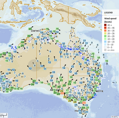


Synoptic | Temp/Rain | Wind | Sea Surface Temp
State
Trough spans QLD. Upper trough brings storms to east. Weakening trough becomes low pressure area. New trough arrives next weekend.


ACCESS 3Hour Rainfall
4-day
Tuesday: Scattered showers and storms across the state with severe thunderstorms possible in central and southern Queensland. Clear in the southwest. Heatwave conditions in the northern interior and northwest.
Wednesday: Showers and thunderstorms in parts of Queensland. Severe storms and heatwave in some areas.
Thursday: Isolated showers and thunderstorms in parts of Queensland, with severe thunderstorm potential near Sarina to Brisbane. Some showers in northern Cape York Peninsula. Sunny in southwest, central, and southern areas. Severe heatwave in northwest, northern interior, west, and southeast. Temperatures near average in Cape York Peninsula, above average elsewhere.
Friday: Isolated showers and possible thunderstorm except in far southwest, showers in eastern districts. Mostly sunny southwest. Severe heatwave in northwest, northern interior, west, and southeast. Temp near average in Cape York, well above average elsewhere.


North Tropical Coast and Tablelands:
The weather will be partly cloudy with a high chance of showers and a thunderstorm, light winds, and temperatures between the low to mid 20s overnight and around 30 during the day.
Herbert and Lower Burdekin:
The weather for tomorrow includes a max temperature in the low to mid 30s with light winds becoming northerly, a high chance of showers in the late morning and afternoon, and overnight temperatures in the low to mid 20s.
Central Coast and Whitsundays:
Max temperature: low 30s, min temperature: low to mid 20s, wind speed: northerly 15 to 25 km/h, wind direction: northerly, rainfall: high chance of showers, Partly cloudy.
Peninsula:
The weather will be partly cloudy with high chance of showers and a thunderstorm, light winds, and temperatures ranging from mid 20s to low to mid 30s.
Gulf Country:
Max temperature: 36 to 42°C, Min temperature: mid to high 20s°C, Wind speed: light to 20 km/h, Wind direction: northwest to northeasterly, Rainfall: medium chance of showers in the north, slight chance elsewhere, Other: partly cloudy, chance of a thunderstorm.
Northern Goldfields and Upper Flinders:
Max temperature: 34 to 41 | Min temperature: low to mid 20s | Wind speed: northwest to northeasterly 15 to 20 km/h, becoming light in the evening | Wind direction: northwest to southwesterly | Rainfall: high chance of showers in the north, medium chance elsewhere | Other: mostly sunny, chance of a thunderstorm.
Capricornia:
The weather will be cloudy with a very high chance of showers and a potential severe thunderstorm, with temperatures ranging from low 20s to low 30s, northerly winds of 15-30 km/h, and overnight temperatures falling.
Central Highlands and Coalfields:
Max temperature: low to mid 30s, Min temperature: low to mid 20s, Wind speed: north to northwesterly 15 to 25 km/h, Wind direction: north to northeasterly 15 to 20 km/h in the evening, Rainfall: Partly cloudy with high chance of showers in the east, medium chance elsewhere, Thunderstorm: with damaging winds, large hail and heavy rain which may lead to flash flooding.
Central West:
Max temperature of 35 to 41 with a chance of thunderstorm in the northeast, winds South to Southwesterly 15 to 25 km/h, rainfall and mostly sunny.
North West:
Maximum temperature of 40, minimum temperature of 19-25, wind speed of 15-25 km/h, wind direction south to southeasterly, chance of thunderstorm in the northeast in the early morning.
Channel Country:
Max temperature: 37, Min temperature: 18, Wind speed: 20 to 30 km/h, Wind direction: South to southwesterly, Rainfall: Sunny
Maranoa and Warrego:
Max temperature: low to mid 30s, Min temperature: 17-20, Wind speed: light becoming westerly 20-30 km/h, Wind direction: westerly, Rainfall: Mostly sunny with chance of thunderstorm in the east morning and afternoon, Other: Overnight temperatures falling.
Darling Downs and Granite Belt:
Max temperature: low to mid 30s, Min temperature: 18-21, Wind speed: 15-25 km/h, Wind direction: north to northwesterly, Rainfall: high chance of showers, Other: Partly cloudy, chance of thunderstorm with severe conditions.
Wide Bay and Burnett:
The weather will be cloudy with temperatures ranging from 19-23 overnight and reaching the low to mid 30s during the day. There is a very high chance of showers and a potential severe thunderstorm with damaging winds, large hail, and heavy rain. Winds will be northerly.
Southeast Coast:
Max temperature: low 30s; Min temperature: 19-22; Wind speed: light winds becoming northerly 15-25 km/h in the morning then light in the evening; Wind direction: northerly; Rainfall: very high chance of showers, most likely in the morning and afternoon; Other: partly cloudy, chance of thunderstorm possibly severe; Overnight temperatures falling to 19-22.
Click here to support to Wally's Weather
National maps by Weatherzone (weatherzone.com.au)
State maps by Windy (Windy.com)
Weather forecast supplemented by Bureau of Meteorology (bom.gov.au)
Rainfall daily totals (https://meteologix.com/ )
AccuWeather (https://www.accuweather.com/)
Nine Weather (https://www.9news.com.au/weather)
Wally's Weather provides professionally researched data and information. Andrew aka 'Wally' has over 20 years of experience in meteorology research and data analysis. In 2023 finished top 4 for the AMOS national weather forecasting competition. The content here is provided as educational information aimed at providing the community and businesses with the tools required to determine local-based forecasts. IMPORTANT: The forecasts and information posted should never be used on their own to make business decisions as local influences.


Comments