Morning Weather - December 8 - Wally's Weather Australia
- Dec 7, 2023
- 5 min read
This weather update is brought to you by Genesis Electrical NQ

Genesis Electrical NQ
We can Solve all of your Electrical, Air Conditioning and Solar needs!
Green Energy Initiative
Phone: 1300 443 637
Email: info@genesislec.com
Special report
Monsoon:
Severe Tropical Cyclone 03P (Jasper) is now moving at 5knots, 1300km ENE of Cairns. So basically we should have named it Uncle Arthur, although at least Jasper is not looping yet.
Jasper has a ridge over the coast slowing its movement, however, that should shift South and allow it to move closer. Again, 4 days out, will be roughly 600km from Cairns, then we would have a good idea.
Storms:
Troughs will bring showers and storms to WA, the NT, SA, NSW, and far north QLD. Hot winds will be directed over the interior and east of the country. A cold front will bring cooling gusty winds and showers to TAS and VIC.
Warnings:
Severe Thunderstorm Warning (Damaging Winds) for parts of Goldfields and Eucla districts.
Strong Wind Warnings for various coastal areas, with cancellations for Geraldton Coast and South West Coast.
Fire Weather Warnings for North East Pastoral, E Eyre, Flinders, Mid North, Mount Lofty Ranges, Yorke Peninsula, Riverland, Mallee, Wimmera, and Northern Riverina and South Western.
Gale Warning for Western and Southern Areas.
Severe Weather Warning (Winds) for multiple districts in South Australia.
Downy Mildew Advice for Mid North and Mount Lofty Ranges.
Strong Wind Warnings for Port Phillip & Central and East Gippsland coasts, Spencer Gulf, Gulf St Vincent, Investigator Strait & Central, South Central & Upper South East coasts, Illawarra, Batemans, and Eden coasts.
Minor Flood Warnings for the Latrobe River and Thomson River.
Additional Fire Weather Warnings for Ashburton Coast and Mortlock.
Storm probabilities 2PM | Rain Accumulation 3 days | Rain 8 x 24 hour accumulated | BOM Tracking


National
A southern Tasman Sea high extends a ridge over the state, persisting over the east. A trough will move east into western Queensland, attached to a low and cold front across southern Australia. Tropical Cyclone Jasper will develop in the Coral Sea, moving towards the central Coral Sea. Jasper will gradually move west towards the northern Queensland coast next week.

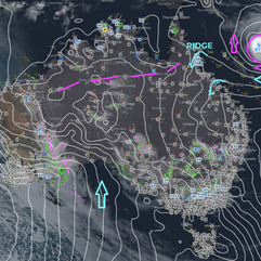


State
A ridge extends northward from a high in the southern Tasman Sea over the state. It will persist over the east during the weekend. A significant trough system attached to a low and cold front will move into western Queensland. Severe Tropical Cyclone Jasper will develop further and move towards the central Coral Sea over the weekend. Jasper is forecast to gradually move westward towards the northern Queensland coast next week.


4-day
Thursday: Isolated showers on east coast north of Mackay. Showers and thunderstorms on western Peninsula and western Gulf Country. Mostly clear elsewhere. Moderate east to northeasterly winds, fresh at times in Central West.
Saturday: Scattered showers on the east coast, isolated storms in the Peninsula and Gulf Country. Partly cloudy on the east coast, mostly sunny elsewhere. Severe heatwave conditions in the southwest, southern interior, and parts of the Far North. High temperatures in the southern interior and western Queensland.
Sunday: Isolated showers on east coast, scattered on Central Coast and Whitsundays. Scattered showers with thunderstorms on Cape York Peninsula. Partly cloudy elsewhere. Strong winds and high seas on east coast north of Bundaberg due to Tropical Cyclone Jasper. Severe heatwave in Far North and far southern interior. Higher than average temperatures in southern inland Queensland.
Monday: Possible rewording: Eastern districts may have scattered showers, while the Central Coast could experience widespread rainfall. The South East Coast may have isolated showers. The Peninsula and Gulf Coast could have isolated showers and thunderstorms. The east coast north of Bundaberg may have increasing winds and seas, which may be impacted by Severe Tropical Cyclone Jasper's position and movement.


North Tropical Coast and Tablelands:
Max temperature: 35, Min temperature: 17, Wind speed: 20-30 km/h, Wind direction: East to southeasterly, Rainfall: Partly cloudy with medium chance of showers near coast and slight chance elsewhere, Overnight temperature: 17-23.
Herbert and Lower Burdekin:
Max temperature: low to mid 30s, Min temperature: 19-23, Wind: Easterly 15-20 km/h becoming light before dawn then becoming easterly 20-30 km/h in the morning, Rainfall: Slight chance of a shower in the north, near zero chance elsewhere, Other: Partly cloudy.
Central Coast and Whitsundays:
Max temperature: 36, Min temperature: low 20s, Wind speed: 25-35 km/h, Wind direction: east to southeasterly, Rainfall: None, Other: Partly cloudy.
Peninsula:
Max temperature: mid to high 30s, min temperature: low to mid 20s, wind speed: 15 to 20 km/h, wind direction: east to northeasterly, rainfall: near zero chance, other: mostly sunny with showers in the west.
Gulf Country:
Max temperature: high 30s, Min temperature: mid 20s, Wind speed: 15 to 25 km/h, Wind direction: east to northeasterly, Rainfall: slight chance of shower near south coast, near zero chance elsewhere, Other: mostly sunny with chance of thunderstorm near coast in morning and afternoon.
Northern Goldfields and Upper Flinders:
Max temperature: 33 to 39, Min temperature: 19 to 23, Wind speed: 20 to 30 km/h (easterly), Wind direction: Easterly, Rainfall: None, Other: Sunny.
Capricornia:
Max temperature: 37, Min temperature: 18, Wind speed: 35 km/h, Wind direction: east to easterly, Rainfall: Mostly sunny.
Central Highlands and Coalfields:
Max temperature: mid to high 30s, Min temperature: 18-21, Wind speed: easterly 25-35 km/h, Wind direction: east to northeasterly 15-20 km/h, Rainfall: None, Other: Sunny.
Central West:
Max temperature: 35 to 40, Min temperature: low to mid 20s, Wind speed: 15 to 25 km/h increasing to 25 to 35 km/h, Wind direction: northeasterly, Rainfall: none, Other: Sunny
North West:
The weather forecast is for a maximum temperature of around 40°C, minimum temperature in the low to mid 20s, winds northeast to east, 15-30 km/h, and no rainfall expected.
Channel Country:
Max temperature: mid 40s, Min temperature: 25 to 31, Wind speed: 25 to 40 km/h, Wind direction: northeasterly, Rainfall: none, Other: Sunny.
Maranoa and Warrego:
Maximum temperature of 43, minimum temperature of 21, wind speed increasing from 15 to 35 km/h, northeasterly winds, and it will be sunny with falling overnight temperatures.
Darling Downs and Granite Belt:
Max temperature: 40, Min temperature: 17, Wind speed: 15-25 km/h, Wind direction: East to northeasterly, Rainfall: None, Other: Sunny.
Wide Bay and Burnett:
Max temperature: 36, Min temperature: 17, Wind speed: Light becoming easterly 20-30km/h, Wind direction: Easterly, Rainfall: None, Other: Mostly sunny with overnight temperatures falling to 17-21.
Southeast Coast:
Max temperature: 34, Min temperature: 17-21, Wind speed: becoming light, Wind direction: east to northeasterly, Rainfall: 0, Mostly sunny
Click here to support to Wally's Weather
National maps by Weatherzone (weatherzone.com.au)
State maps by Windy (Windy.com)
Weather forecast supplemented by Bureau of Meteorology (bom.gov.au)
Rainfall daily totals (https://meteologix.com/ )
AccuWeather (https://www.accuweather.com/)
Nine Weather (https://www.9news.com.au/weather)
Wally's Weather provides professionally researched data and information. Andrew aka 'Wally' has over 20 years of experience in meteorology research and data analysis. In 2023 finished top 4 for the AMOS national weather forecasting competition. The content here is provided as educational information aimed at providing the community and businesses with the tools required to determine local-based forecasts. IMPORTANT: The forecasts and information posted should never be used on their own to make business decisions as local influences.


Comments