Morning Weather - December 9 - Wally's Weather Australia
- Dec 8, 2023
- 6 min read
This weather update is brought to you by Genesis Electrical NQ

Genesis Electrical NQ
We can Solve all of your Electrical, Air Conditioning and Solar needs!
Green Energy Initiative
Phone: 1300 443 637
Email: info@genesislec.com
Wally is TODAY at 11am at Gecko Interiors, a shop that has fun, colourful, quirky gifts like Wally's new board game Dam Filler! He is passionate about education and would love for you to have your very own slice of Townsville history. Learn all about the dome, basic maths, geography, weather and other STEM topics.

Special report
Monsoon:
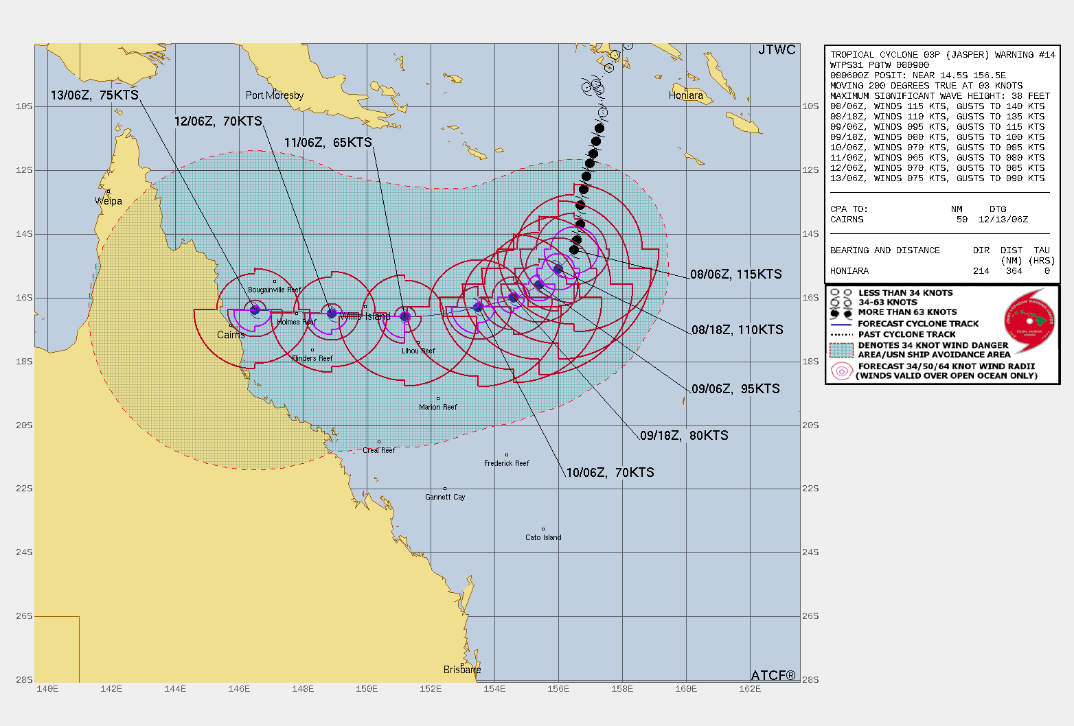
Severe Tropical Cyclone 03P (Jasper) is exoected to move SSW to SW at a greater speed than today. It is expected to make land by the 13th and cross by the 14th, the SW quadrant of the storm is likely to be felt over Cairns and the system will be destructive from Cooktown down to Cardwell. That seems to be where there is alignment between all models, and of course these will likely change as we see exactly what Jasper does on the 9th Dec. There are two major factors at play, the ridging along the coast acting like a ramp to shift the system more to the North and the speed of the cyclone. It is likely to cross as a Cat 2, possibly still a cat 3. Overnight has travelled at 8km/h SSW. Still no signs of diverting more West.
Storms:
A trough will move eastward, bringing hot air to the east coast of NSW and triggering storms in WA, NT, NSW, and parts of northeast Vic. Cooler winds and rain/showers are expected for SA and southern Vic behind the trough. Severe Tropical Cyclone Jasper will maintain strong winds and rain well offshore.
Warnings
(Damaging Winds And Heavy Rainfall) for parts of North West Pastoral district, Lasseter district, and South Coast and Southern Tablelands.
Strong Wind Warning for Hunter, Sydney, Illawarra, Batemans, and Eden coasts.
Murraylands, North West Pastoral & North East Pastoral districts.
Strong Wind Warning Pilbara Coast East, Per Local & Ningaloo, Gascoyne, Geraldton, Lancelin, Perth, Bunbury Geographe & Eucla coasts.
Severe Weather Warning (Damaging Winds) for Central, N Central & E Gippsland, Mallee, South West, N Country, NE, W & S Gippsland & Wimmera.
Strong Wind Warning for East Gippsland Coast. Cancellation for Port Phillip & Central Coast.
Fire Weather Warning for Midwest Coast, Midwest Inland, Yarra Yarra, Swan Inland North, Swan Inland South, Brockman, and Mortlock.
Strong Wind Warning for Banks Strait and Franklin Sound, East of Flinders Island & Central North, Upper East and Lower East coasts.
Sheep Graziers Warning for Eastern Eyre Peninsula, Yorke Peninsula, and Mount Lofty Ranges.
Storm Force Wind Warning For Western And Southern Areas.
Downy Mildew Advice for Saturday for Mid North and Mount Lofty Ranges.
Strong Wind Warning Spencer Gulf. Cancelled Gulf St Vincent, Invest St, Adelaide Waters & Central, South Central & Upper SE Coasts.
Fire Weather Warning for Greater Sydney Region, Lower Central West Plains, Southern Slopes, Northern Riverina, and South Western.
Multiple Heatwave Warnings for various regions across Australia.
Minor Flood Warning For The Paroo River (Qld).
Initial Flood Watch For The Mt Lofty Ranges, Mid North And Eyre Peninsula.
Minor Flood Warnings for the Barcoo River, Paroo River (Nsw), Latrobe River, and Thomson River.
Additional Fire Weather Warnings for NE Pastoral, West Coast, E Eyre, Flinders, Mid North, Mt Lofty R, Yorke Peninsula, Riverland, Murraylands & Upper SE, Mallee, and Wimmera.
Storm probabilities 2PM | Rain Accumulation 3 days | Rain 8 x 24 hour accumulated | BOM Tracking


National
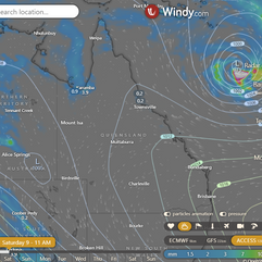
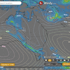
High in southern Tasman Sea extends ridge northward over state, persists through weekend. Trough and southerly change move into western Queensland. Cyclone Jasper in northeastern Coral Sea moves west over weekend, risk of coastal crossing mid next week.


State
A high in the Tasman Sea extends over most of the state, will stay for the weekend. A trough and change will move into western Queensland over the weekend. Cyclone Jasper in the Coral Sea may cross the coast mid next week.


4-day
Saturday: Isolated showers on the east coast, scattered on the North Tropical Coast. Isolated showers on the southern Gulf coast and Cape York Peninsula. Partly cloudy on the east coast, mostly clear elsewhere. Moderate to fresh east to northeasterly winds.
Sunday: Isolated showers on the East Coast, scattered on the Central Coast and Whitsundays. Showers and thunderstorms on Cape York Peninsula. Partly cloudy elsewhere, sunny inland, with gusty winds and possible raised dust in Channel Country. Severe heatwave in parts of Far North and southern interior. High temperatures in southern inland Queensland.
Monday: Eastern districts: scattered showers, Central Coast and Whitsundays: widespread showers, South East Coast: isolated showers. Peninsula and Gulf Coast: isolated showers and thunderstorms. Increasing winds and seas north of Bundaberg due to Severe Tropical Cyclone Jasper.
Tuesday: Scattered showers and thunderstorms in northeastern Queensland, possibly becoming widespread with heavy rainfall and damaging winds depending on Severe Tropical Cyclone Jasper. Isolated showers along the east coast. Partly cloudy elsewhere. Increasing winds and seas on the east coast north of Bundaberg. Above average maximum temperatures in inland southern Queensland.


North Tropical Coast and Tablelands:
Max temperature: 36 Min temperature: 17 Wind speed: 20-30 km/h Wind direction: East to southeasterly Rainfall: Slight chance of shower along coastal fringe, near zero chance elsewhere.Mostly sunny. Overnight temperatures falling to between 17-23. Daytime temperatures reaching 29-36.
Herbert and Lower Burdekin:
Max temperature: low to mid 30s, Min temperature: 18-23, Wind speed: 15-30 km/h, Wind direction: east to northeasterly, Rainfall: slight chance of shower in the north, near zero chance elsewhere, Other: Partly cloudy.
Central Coast and Whitsundays:
Max temperature: 36, Min temperature: low 20s, Wind speed: 25 to 35 km/h, Wind direction: east to southeasterly, Rainfall: Slight chance of a shower, Other: Partly cloudy.
Peninsula:
Max temperature: mid to high 30s, Min temperature: low to mid 20s, Wind speed: 15-25 km/h, Wind direction: east to northeasterly, Rainfall: High chance of showers in the west, slight chance elsewhere, Other: Mostly sunny, chance of thunderstorm in late morning.
Gulf Country:
Max temperature: 40, Min temperature: mid to high 20s, Wind speed: 15-25 km/h, Wind direction: NW-NE, Rainfall: Medium chance of showers, Other: Mostly sunny, Chance of thunderstorm in the north.
Northern Goldfields and Upper Flinders:
Max temperature: 39, Min temperature: 18-23, Wind speed: 15-25 km/h, Wind direction: east to northeasterly, Rainfall: Sunny, Other: Overnight temperatures falling.
Capricornia:
Max temperature: 36, Min temperature: 18, Wind speed: 20-30 km/h, Wind direction: Easterly, Rainfall: None, Other: Partly cloudy.
Central Highlands and Coalfields:
Maximum temperature: mid to high 30s; Minimum temperature: 18 to 21; Wind speed: easterly 20 to 30 km/h; Wind direction: east to northeasterly; Rainfall: Mostly sunny; Others: Overnight temperatures falling before dawn.
Central West:
Maximum temperature: 35 to 40 degrees Celsius; Minimum temperature: low to mid 20s; Wind speed: 20 to 30 km/h; Wind direction: northeasterly; Rainfall: Sunny.
North West:
Max temperature: 40°C, Min temperature: low to mid 20s, Wind speed: 15-25km/h, Wind direction: east to northeasterly, Rainfall: N/A, Other: Sunny.
Channel Country:
Max temperature: low 40s, Min temperature: mid to high 20s, Wind speed: 25 to 40 km/h, Wind direction: north to northeasterly, Rainfall: none, Weather conditions: Sunny with a chance of raised dust in the northwest.
Maranoa and Warrego:
The maximum temperature will be around 40 with overnight temperatures falling to 20 to 27, sunny weather with winds starting from the north to northeasterly at 20 to 30 km/h and shifting to east to northeasterly at 15 to 25 km/h in the early afternoon, and no rainfall.
Darling Downs and Granite Belt:
Max temperature: 39, Min temperature: 17, Wind speed: 20-30 km/h (north easterly), Wind direction: northern, Rainfall: None, Other: Sunny.
Wide Bay and Burnett:
Max temperature: 35, Min temperature: 17, Wind speed: 15-25 km/h, Wind direction: easterly, Rainfall: N/A, Other: Partly cloudy.
Southeast Coast:
Max temperature: 30, Min temperature: 18-22, Wind: Light to 20 km/h, Wind direction: East to northeasterly, Rainfall: None, Conditions: Partly cloudy.
Click here to support to Wally's Weather
National maps by Weatherzone (weatherzone.com.au)
State maps by Windy (Windy.com)
Weather forecast supplemented by Bureau of Meteorology (bom.gov.au)
Rainfall daily totals (https://meteologix.com/ )
AccuWeather (https://www.accuweather.com/)
Nine Weather (https://www.9news.com.au/weather)
Wally's Weather provides professionally researched data and information. Andrew aka 'Wally' has over 20 years of experience in meteorology research and data analysis. In 2023 finished top 4 for the AMOS national weather forecasting competition. The content here is provided as educational information aimed at providing the community and businesses with the tools required to determine local-based forecasts. IMPORTANT: The forecasts and information posted should never be used on their own to make business decisions as local influences.


Comments