Morning Weather - February 15 - Wally's Weather Australia
- Feb 14, 2024
- 5 min read
This weather update is brought to you by Genesis Electrical NQ

Genesis Electrical NQ
We can Solve all of your Electrical, Air Conditioning and Solar needs!
Phone: 1300 443 637
Email: info@genesislec.com
Monsoon Update
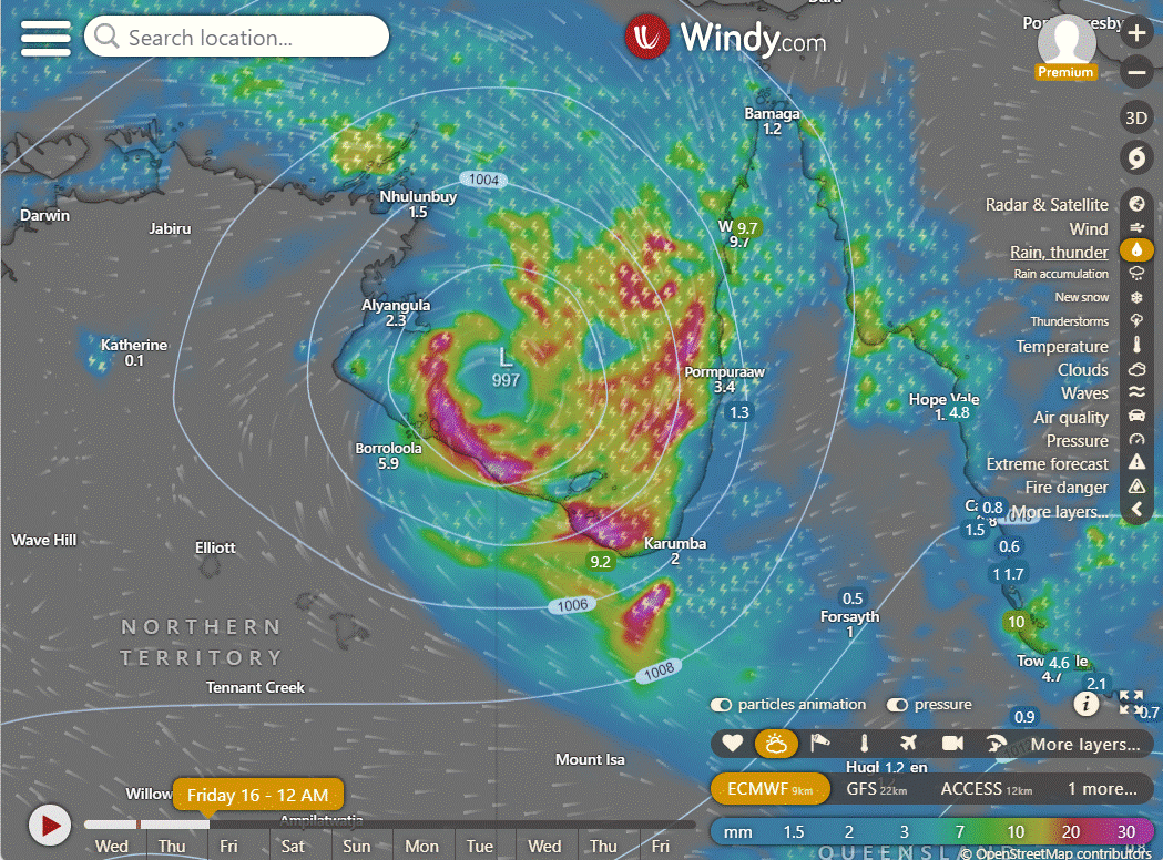
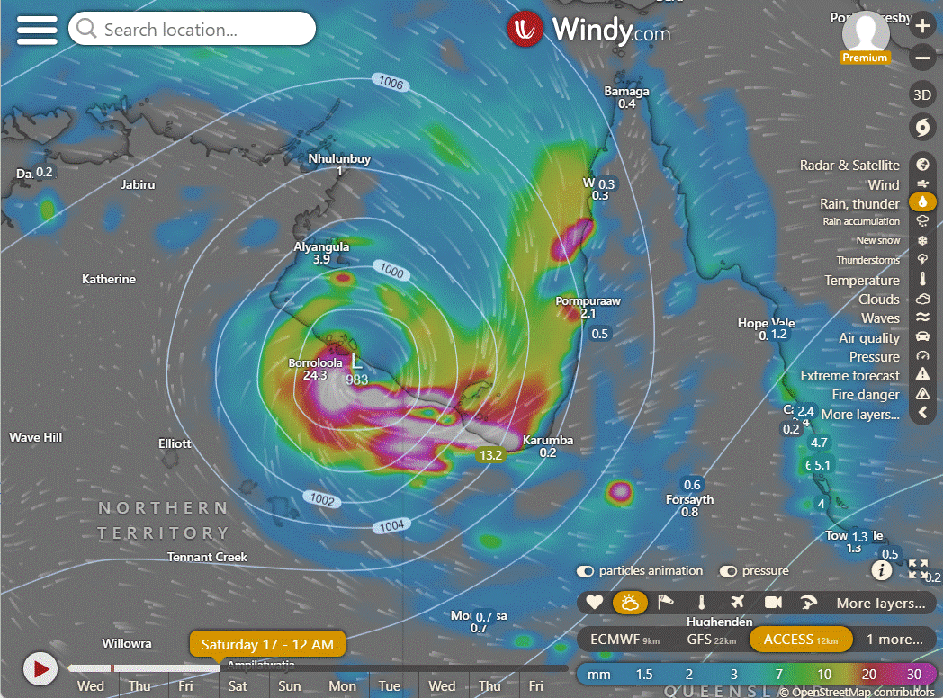
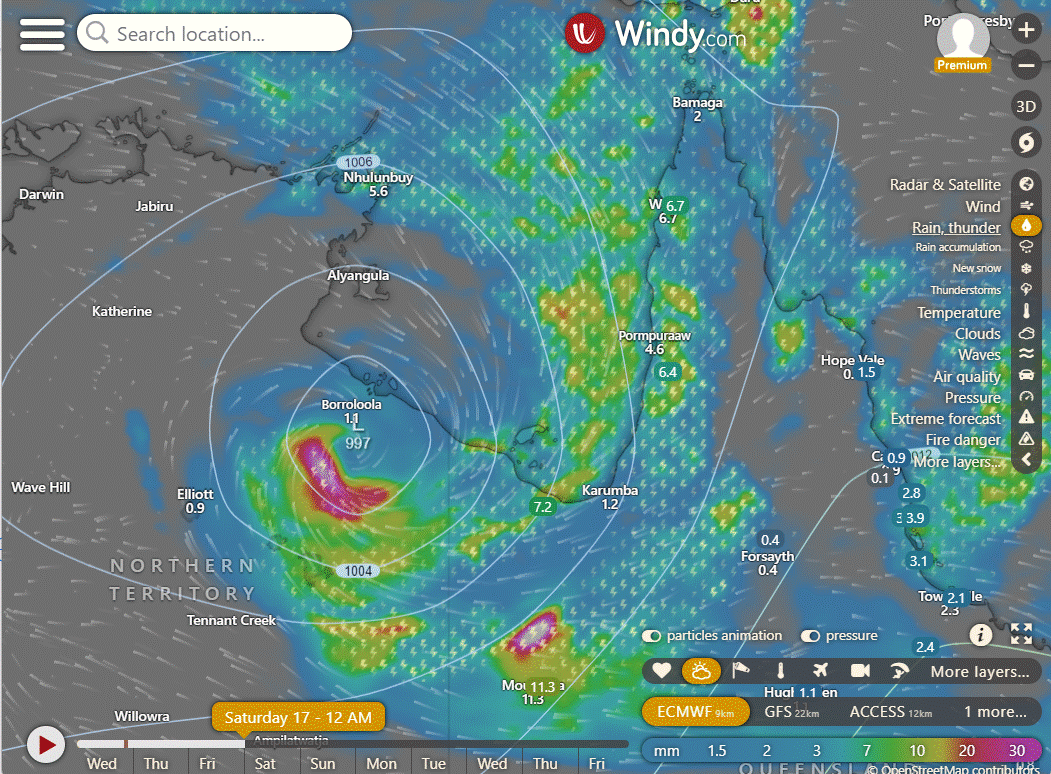
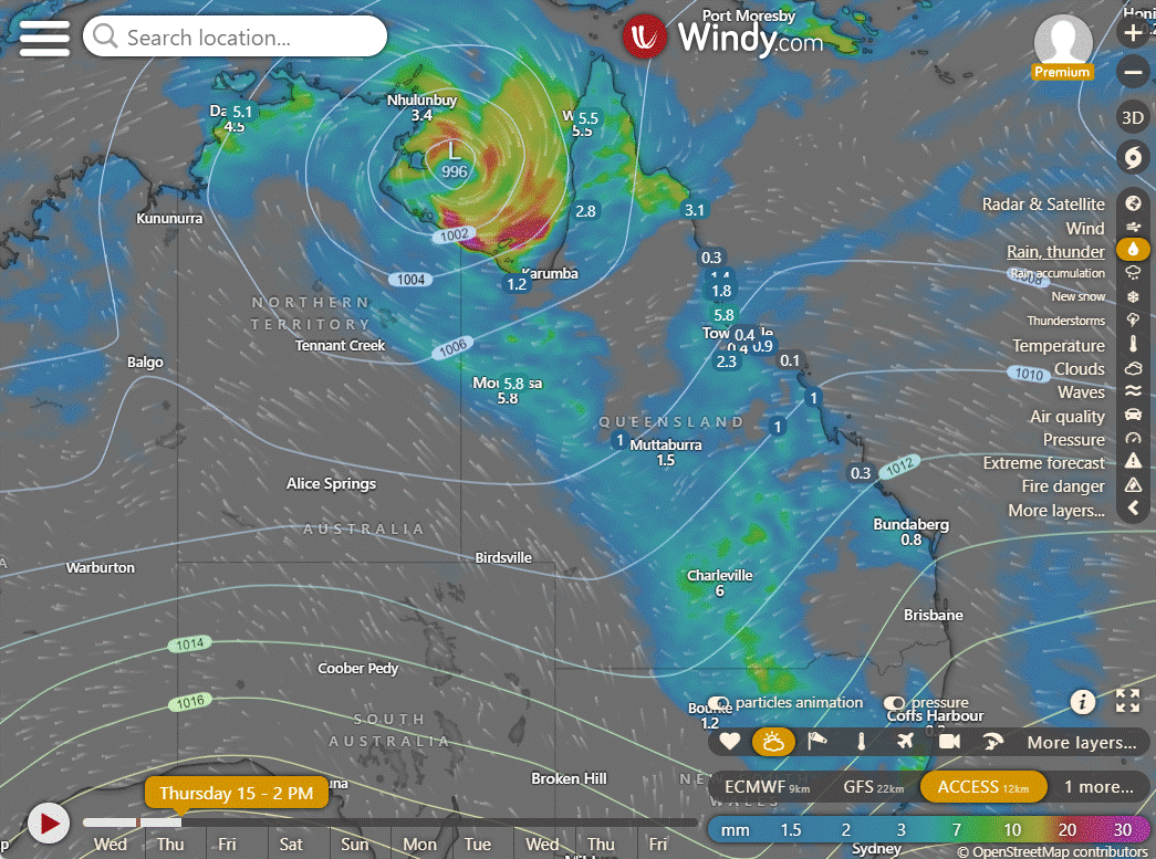
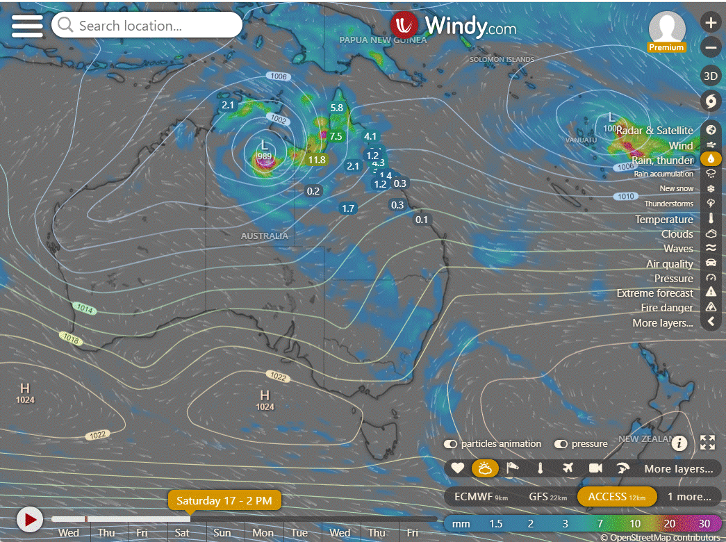
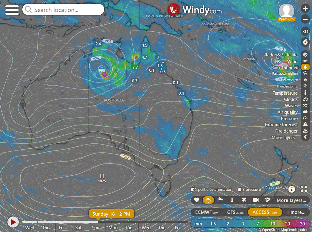
With 07U/93S has moved into the Gulf and now the finer movements are crucial to determine if it will have enough time to deepen into a tropical cyclone, and if it will produce much rain for the NQ coastline. It appears that neither is likely at this stage, but a delay and continued movement to the ENE could improve those chances. ACCESS is very confident of a lot of rain for the Gulf, to a lesser extent the GFS and slightly more optimistic is the EC model. The next day is shown on the bottom row. As you can see its looking like a fast exit of the Gulf. Not huge amounts for the NQ coast but some rain will be welcome.
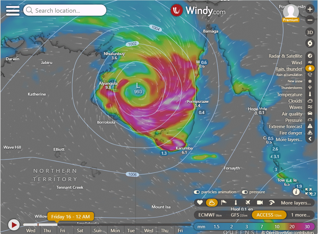


The system is about 775 kilometers east-southeast of Darwin. The sea is very warm (30-31°C), and there's good airflow in the upper atmosphere. The strongest winds within the storm are estimated to be between 23 to 28 knots. The minimum air pressure at sea level is estimated to be around 1003 hPa. There's a medium chance that this weather system could develop into a significant tropical cyclone within the next 24 hours.
National
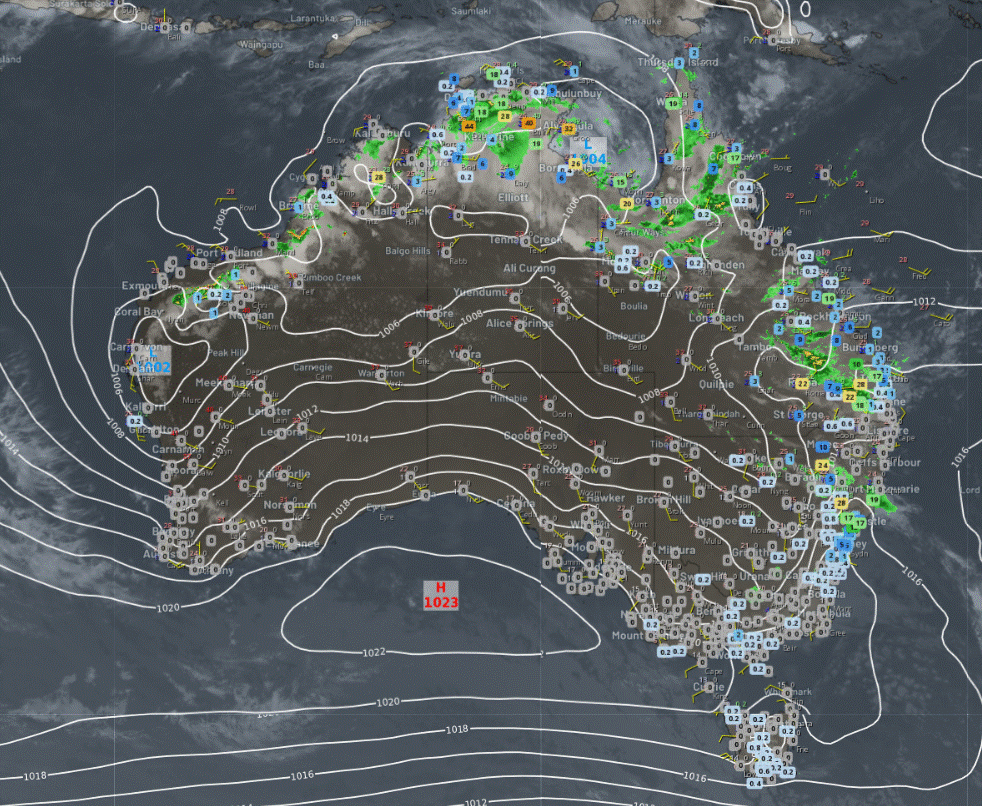
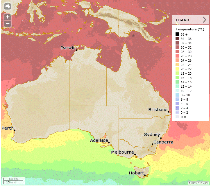
Monsoon low causing rain and storms in the tropics. Showers and storms across northern and central-eastern QLD and NSW. Hot and dry conditions in WA with a heatwave
Showers in southwest TAS due to unstable westerly flow. High pressure ridge keeping other areas dry

Synoptic | Temp/Rain | Wind | Sea Surface Temp
State
A growing weather system is forming over the Gulf of Carpentaria and western Peninsula, including a possible cyclone. This system is likely to move southwest, impacting the Northern Territory and weakening as it heads west. Eastern Queensland may experience unsettled weather, while the east coast can expect increased rainfall later in the week.


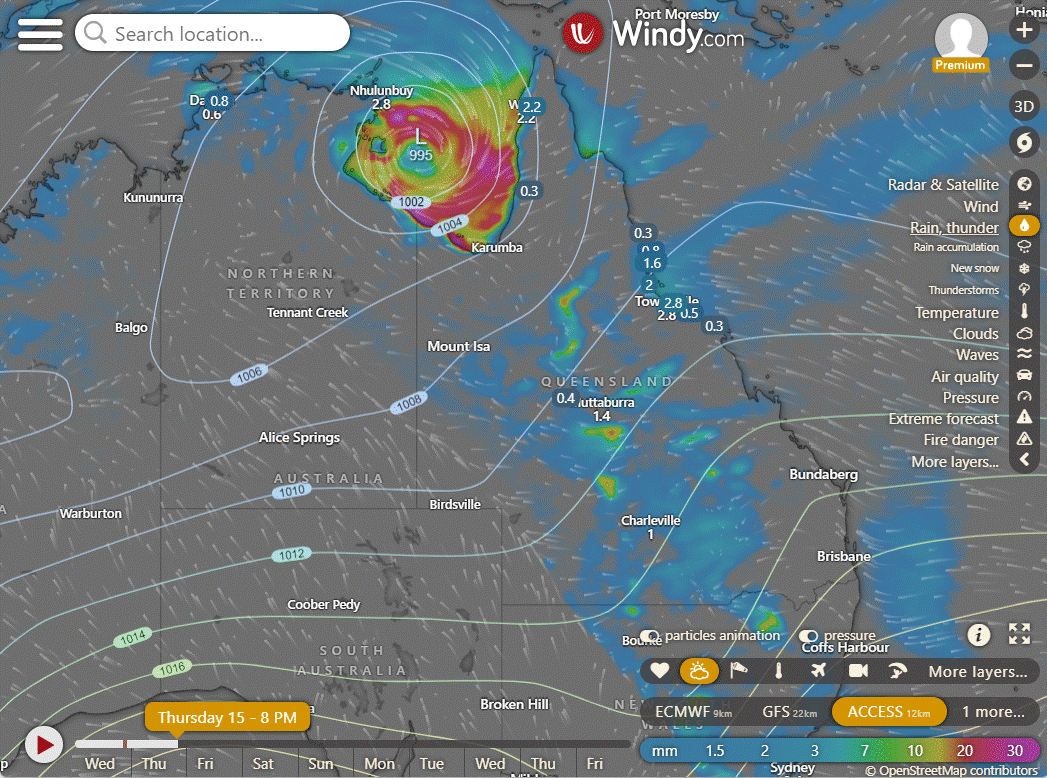
ACCESS (Values are rainfall over 3 hours)
4-day
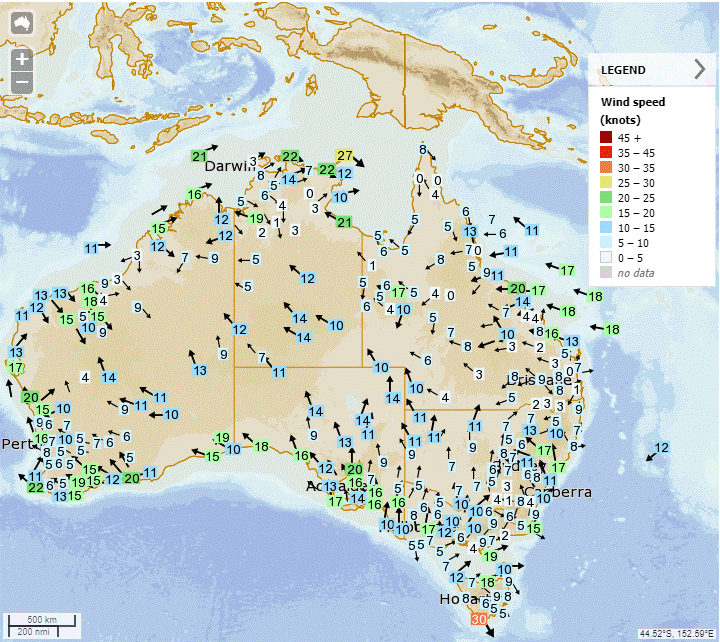
Thursday: Scattered showers and isolated thunderstorms across the state, mainly in the southwest, southeast Queensland, and North Tropical Coast. Widespread showers and rain at times on the Peninsula and Gulf Country coast. Light to moderate winds from the northeast to southeast, with light northwesterly winds on the northern Peninsula and Torres Strait.
Friday: Isolated thunderstorms & showers, heavy rain possible for Peninsula, Gulf Country & North Tropical Coast. Scattered showers & thunderstorms for eastern districts, winds may reach gale force in Gulf Country. Max temps below average statewide.
Saturday: Saturday: Thunderstorms, showers likely with heavy rain in places. Isolated showers elsewhere. Damaging winds possible in the west. Cooler temperatures in the northwest, average elsewhere.
Sunday: Expect thunderstorms and showers for some areas, with possibly heavy rainfall. Other areas may have isolated showers. Central and southern interior will be partly cloudy. Below average temperatures in the northwest, near average elsewhere.


North Tropical Coast and Tablelands:
The summary for the weather conditions is: Max temperature of 30°C, min temperature between 19 and 24°C, easterly winds of 15 to 25 km/h, partly cloudy with high chance of showers and thunderstorms.
Herbert and Lower Burdekin:
Max temperature: 30, Min temperature: low to mid 20s, Wind speed: light becoming easterly 15 to 25 km/h in the morning then light in the late evening, Wind direction: easterly, Rainfall: High chance of showers, most likely in late morning and afternoon, Other: Partly cloudy, chance of a thunderstorm inland.
Central Coast and Whitsundays:
Max temperature: around 30, Min temperature: low to mid 20s, Wind speed: easterly 15 to 20 km/h becoming light before dawn then becoming easterly 20 to 30 km/h early in the morning, Wind direction: easterly, Rainfall: High chance of showers with a chance of a thunderstorm, Other: Partly cloudy.
Peninsula:
Max temperature: 30, Min temperature: low to mid 20s, Wind speed: 15 to 25 km/h, Wind direction: east to northeasterly, Rainfall: showers, Thunderstorm: possible
Gulf Country:
Max temperature: 30°C, Min temperature: mid 20s, Wind speed: 20-30 km/h, Wind direction: northeast to southeasterly, Rainfall: Very high chance of rain, most likely from late morning, Other: Cloudy, chance of thunderstorm, heavy falls possible in the west.
Northern Goldfields and Upper Flinders:
Max temperature: low to mid 30s, min temperature: low to mid 20s, wind speed: light becoming easterly 15 to 25 km/h, wind direction: easterly, rainfall: high chance of showers in the afternoon and evening, chance of a thunderstorm.
Capricornia:
Max temperature: low 30s, Min temperature: low to mid 20s, Wind speed: light winds becoming easterly 20 to 30 km/h in the morning, Wind direction: easterly, Rainfall: high chance of showers, most likely in the afternoon and evening, Other: Partly cloudy with chance of a thunderstorm.
Central Highlands and Coalfields:
Max temperature: 30°C, Min temperature: low 20s, Wind speed: becoming easterly 15-25 km/h, Wind direction: east, Rainfall: high chance of showers and a chance of thunderstorm, Other: Partly cloudy.
Central West:
The weather will be partly cloudy with high chances of showers and a thunderstorm. Maximum temperature will be in the low to mid 30s while minimum temperature will be in the low to mid 20s. Wind speed will be east to northeasterly at 15 to 25 km/h.
North West:
Max temperature: 37°C, Min temperature: mid 20s, Wind speed: light winds becoming easterly 20-30 km/h in the morning, Wind direction: east, Rainfall: high chance of showers in the northeast, medium chance elsewhere, Other: partly cloudy, chance of thunderstorm.
Channel Country:
The day will be mostly sunny with a slight chance of a shower in the east, near zero chance of rain elsewhere, and a chance of severe thunderstorms later in the morning. Winds will be east to southeasterly at 25 to 35 km/h, and temperatures will range from the mid to high 20s overnight, reaching 34 to 41 during the day.
Maranoa and Warrego:
Max temperature: 35, Min temperature: low 20, Wind speed: 15-20 km/h, Wind direction: northeasterly to east, Rainfall: high chance of showers, Other: partly cloudy, chance of severe thunderstorm in the west.
Darling Downs and Granite Belt:
Max temperature: low to mid 30s; Min temperature: 19-22; Wind: light increasing to 15-20 km/h in the morning, then becoming easterly 20-30 km/h in the late afternoon; Rainfall: High chance of showers in the west, medium chance elsewhere; Other: Partly cloudy, chance of a thunderstorm.
Wide Bay and Burnett:
Max temperature: 30, Min temperature: low 20s, Wind speed: light becoming easterly 15-25 km/h, Wind direction: becoming light, Rainfall: high chance of showers, Thunderstorm: possible.
Southeast Coast:
Max temperature: 30, Min temperature: low 20s, Wind speed: light, Wind direction: east to southeasterly, Rainfall: medium chance of showers, Partly cloudy.
WEATHER WARNINGS
Strong Wind Warning for North East Gulf of Carpentaria
Strong Wind Warning for Arafura, Gove Peninsula, and Roper Groote coasts
Strong Wind Warning for Thursday for Esperance Coast
Gale Warning for Southeastern and Southern Areas
Strong Wind Warning for Sydney Enclosed Waters & Hunter, Sydney, and Illawarra coasts
Fire Weather Warning for Midwest Inland, Lesueur, Yarra Yarra, Swan Coastal North, Swan Inland North, Blackwood, Mortlock & Stirling North
Tropical Cyclone Watch for Port Roper (NT) to Burketown (Qld), inc Mornington Island and Borroloola, excluding Ngukurr
Strong Wind Warning for Spencer Gulf
Strong Wind Warning for South East and South West coasts
Flood warnings for various rivers, including Nicholson River, Flinders River, Katherine River, Barcoo River, Cooper Creek, Balonne River, Diamantina River, Lower Warrego River, Paroo River, Eyre Creek, Georgina River, Moonie River, and Dawson River
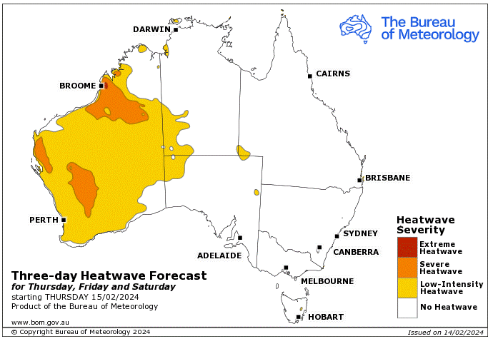
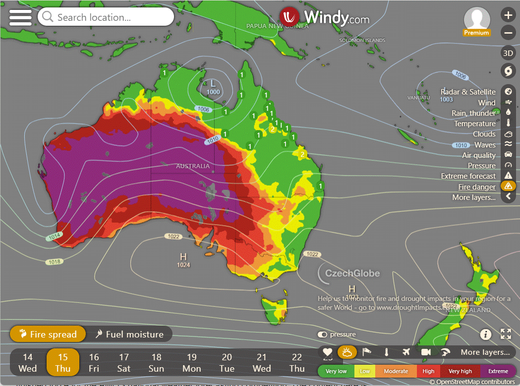
Storms - Heatwave - Fire danger
Click here to support to Wally's Weather
National maps by Weatherzone (weatherzone.com.au)
State maps by Windy (Windy.com)
Weather forecast supplemented by Bureau of Meteorology (bom.gov.au)
Rainfall daily totals (https://meteologix.com/ )
AccuWeather (https://www.accuweather.com/)
Nine Weather (https://www.9news.com.au/weather)
Wally's Weather provides professionally researched data and information. Andrew aka 'Wally' has over 20 years of experience in meteorology research and data analysis. In 2023 finished top 4 for the AMOS national weather forecasting competition. The content here is provided as educational information aimed at providing the community and businesses with the tools required to determine local-based forecasts. IMPORTANT: The forecasts and information posted should never be used on their own to make business decisions as local influences.


Comments