Morning Weather - February 20 - Wally's Weather Australia
- Feb 19, 2024
- 5 min read
This weather update is brought to you by Genesis Electrical NQ

Genesis Electrical NQ
We can Solve all of your Electrical, Air Conditioning and Solar needs!
Phone: 1300 443 637
Email: info@genesislec.com
Monsoon Update
Ex TC Lincoln continues to move West and the alignment of the models is only close 3 days out. Which puts it out over water, and could be very weak to a small intense little system. Often these types of systems pause over the coast and could fail to move into the water completely.


National
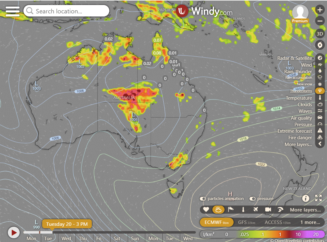
Rain, storms, and showers persist across the tropics, heaviest in the northwest due to ex Tropical Cyclone Lincoln. Showers and storms across eastern Australia aided by humid easterlies. High-pressure ridge keeps elsewhere settled while directing hot winds to WA and SA.


Synoptic | Temp/Rain | Wind | Sea Surface Temp
State
Equatorial trough shifts to Gulf of Carpentaria. Showers in North Queensland. Ridge lingers in eastern Queensland. Showers in southeast. Trough moves across west, interior Queensland later.


ACCESS (Values are rainfall over 3 hours)
4-day
Tuesday: Thunderstorms in Gulf Country & Peninsula, showers in east. Showers in remaining east districts. Showers in south inland & southeast QLD, heavy rain possible. Severe storms in SE QLD. Winds vary.
Wednesday: Patchy showers, thunderstorms in northwest, isolated elsewhere. Max temps below average in west, near average elsewhere.
Thursday: Showers and storms in northern Queensland, becoming widespread in some areas. Showers and chance of storms in eastern districts, mainly showers in the South East. Thunderstorms in central and southern areas, isolated in the southwest. Varying temperatures across the region.
Friday: Showers and storms mainly in the north, becoming more widespread in some areas. Partly cloudy with chance of severe storms in southeast. Temps vary but generally near average.


North Tropical Coast and Tablelands:
The weather forecast is for a partly cloudy day with a high chance of showers, most likely in the late morning and afternoon, with the possibility of a thunderstorm in the north, light winds becoming easterly 15 to 20 km/h in the early afternoon then becoming light in the evening, and overnight temperatures falling to between 19 and 24, with daytime temperatures reaching 27 to 32.
Herbert and Lower Burdekin:
The weather will be hot with low to mid 30s temperature, light winds becoming easterly at 15 to 20 km/h, and a high chance of showers likely in the afternoon and evening with overnight temperatures falling to the low 20s.
Central Coast and Whitsundays:
Max temp: around 30, Min temp: low 20s, Wind: east to southeasterly 15-20 km/h becoming light, Rain: Medium chance of showers in the afternoon and evening. Partly cloudy.
Peninsula:
Max temperature: low to mid 30s; Min temperature: low to mid 20s; Wind speed: light; Wind direction: variable; Rainfall: Very high chance of showers, most likely from late morning, chance of a thunderstorm, Cloudy.
Gulf Country:
Max temperature: low to mid 30s, Min temperature: mid 20s, Wind speed: Light, Wind direction: Not specified, Rainfall: Showers likely, Other: Partly cloudy with chance of thunderstorm.
Northern Goldfields and Upper Flinders:
Maximum temperature: low to mid 30s, Minimum temperature: 19 to 23, Wind speed: 15 to 20 km/h, Wind direction: east to northeasterly, Rainfall: Medium chance of showers in the north, Other: Partly cloudy with a chance of thunderstorm in the north and becoming easterly 15 to 20 km/h in the early afternoon.
Capricornia:
The weather will be mostly sunny with a maximum temperature in the low 30s, a minimum temperature between 19 and 23, light winds becoming easterly 15 to 20 km/h, a medium chance of showers in the afternoon and evening, and the possibility of a thunderstorm in the southwest.
Central Highlands and Coalfields:
Partly cloudy with temperatures reaching low to mid 30s, light winds, chance of showers in Carnarvon Ranges, slight chance elsewhere, chance of thunderstorm in south, overnight temps around 20°C.
Central West:
The weather is expected to be warm with a maximum temperature of 38°C, minimum temperature in the low to mid 20s, light winds becoming stronger from north to east, slight chance of a shower in the southwest, near zero chance elsewhere, and a chance of thunderstorm south of Longreach in the afternoon and evening.
North West:
Max temperature: 32-37°C, Min temperature: Low to mid 20s, Wind speed: Light, Wind direction: Slight chance of shower in northwest, Rainfall: Near zero chance, Other: Partly cloudy, chance of thunderstorm in northwest.
Channel Country:
The weather will have maximum temperature around 40°C, minimum temperature in the mid to high 20s, light winds becoming northwest to northeasterly 15 to 20 km/h, slight chance of a shower, chance of a thunderstorm, and mostly sunny morning.
Maranoa and Warrego:
The weather forecast includes a maximum temperature of 38°C, minimum temperature in the low to mid 20s°C, light winds, partly cloudy skies with a slight chance of a shower, and the possibility of a thunderstorm in the afternoon and evening.
Darling Downs and Granite Belt:
Partly cloudy with showers, thunderstorms possible. Highs 28-34°C, lows 17-21°C. Light winds, varying direction.
Wide Bay and Burnett:
The weather forecast for the day includes a maximum temperature of around 30°C, minimum temperature dropping to 18-21°C, wind speeds starting light and increasing to 15-20 km/h easterly in the late afternoon, a chance of showers especially in the late morning and afternoon with a possibility of inland thunderstorms in the morning and afternoon, and partly cloudy conditions overall.
Southeast Coast:
Max temperature around 30, min temperature between 18-21, light winds, high chance of showers in late morning/afternoon, chance of thunderstorm, partly cloudy.
WEATHER WARNINGS
Strong Wind Warning for Tuesday for East Gippsland Coast.
Severe Thunderstorm Warning (Heavy Rainfall) for parts of Gregory district.
Severe Weather Warning (Heavy Rainfall) for parts of Kimberley district.
Fire Weather Warning for Swan Inland North, Swan Inland South, Capes, Brockman, Blackwood, Southern Forests, Karroun, Lockwood, Arthur, Roe.
Strong Wind Warning for Tuesday for North Kimberley Coast.
Severe Weather Warning (Heavy Rainfall) for parts of Gregory and Tanami districts.
Strong Wind Warning for Tuesday for Beagle Bonaparte Coast.
Final Gale Warning For Southern Area.
Gale Warning For Western Area.
Minor Flood Warning For The Paroo River (Qld).
Minor Flood Warning For The Bokhara River.
Major Flood Warning For The Flinders River.
Minor Flood Warning For The Bulloo River.
Minor Flood Warning For The Barcoo River And Cooper Creek.
Flood Watch For East, West And North Kimberley And Fitzroy Rivers And Sturt Creek District.
Major Flood Warning For The Diamantina River.
Flood Watch For Parts Of Bonaparte Coastal Rivers, Carpentaria Coastal Rivers, Central Inland Rivers And Kimberley.
Major Flood Warning For The Nicholson River.
Minor Flood Warning For The Daly River.
Final Flood Watch For Gulf Of Carpentaria Catchments.
Flood Warning For The Inland Rivers Sa.
Minor Flood Warning For The Paroo River (Nsw).
Final Flood Warning For The Tully River.
Moderate Flood Warning For Eyre Creek And Minor Flood Warning For The Georgina River.
Final Flood Warning For The Lower Warrego River (Qld).
Final Flood Warning For The Mary River.
Final Flood Warning For The Moonie River.
Minor Flood Warning For The Dawson And Isaac Rivers.
Fire Weather Warning for MidW Cst, Midwest Inland, Lesueur, Yarra Yarra, Swan Cstal North, Swan Inland North, Swan Inland South, Capes, Brockman.


Storms - Heatwave - Fire danger
Click here to support to Wally's Weather
National maps by Weatherzone (weatherzone.com.au)
State maps by Windy (Windy.com)
Weather forecast supplemented by Bureau of Meteorology (bom.gov.au)
Rainfall daily totals (https://meteologix.com/ )
AccuWeather (https://www.accuweather.com/)
Nine Weather (https://www.9news.com.au/weather)
Wally's Weather provides professionally researched data and information. Andrew aka 'Wally' has over 20 years of experience in meteorology research and data analysis. In 2023 finished top 4 for the AMOS national weather forecasting competition. The content here is provided as educational information aimed at providing the community and businesses with the tools required to determine local-based forecasts. IMPORTANT: The forecasts and information posted should never be used on their own to make business decisions as local influences.


Comments