Morning Weather - February 4 - Wally's Weather Australia
- Feb 3, 2024
- 6 min read
This weather update is brought to you by Genesis Electrical NQ

Genesis Electrical NQ
We can Solve all of your Electrical, Air Conditioning and Solar needs!
Phone: 1300 443 637
Email: info@genesislec.com
Monsoon update
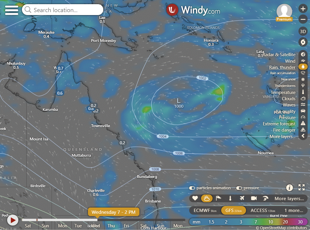
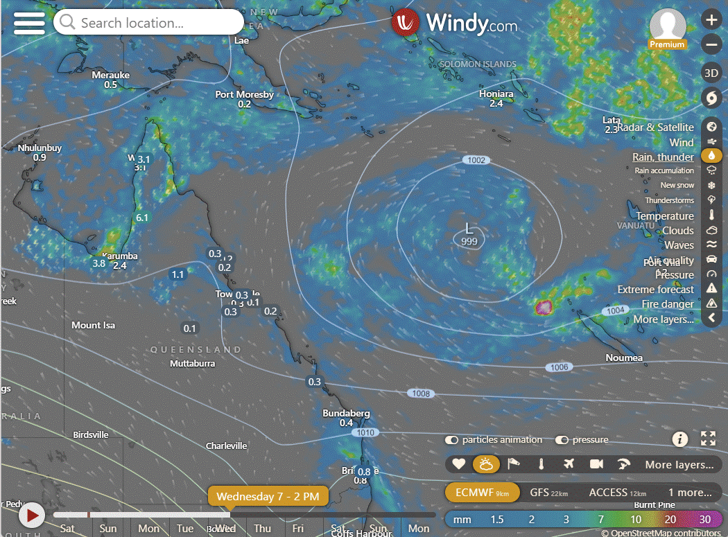
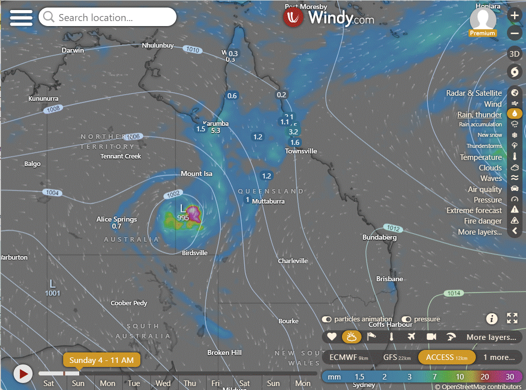
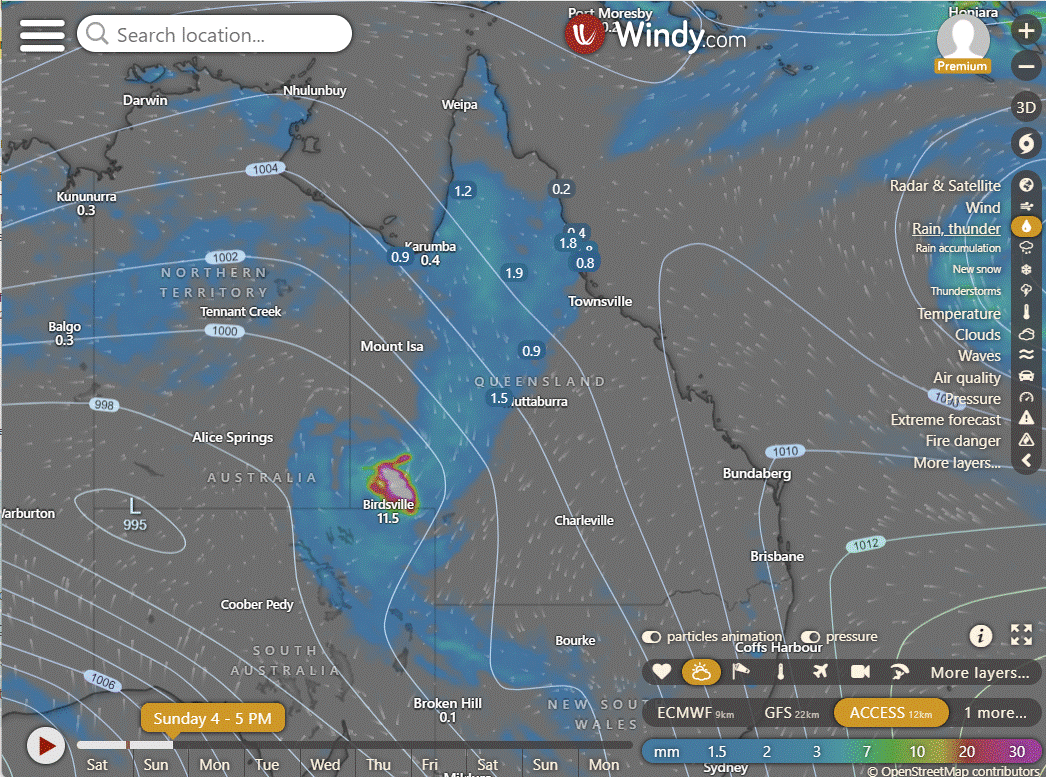
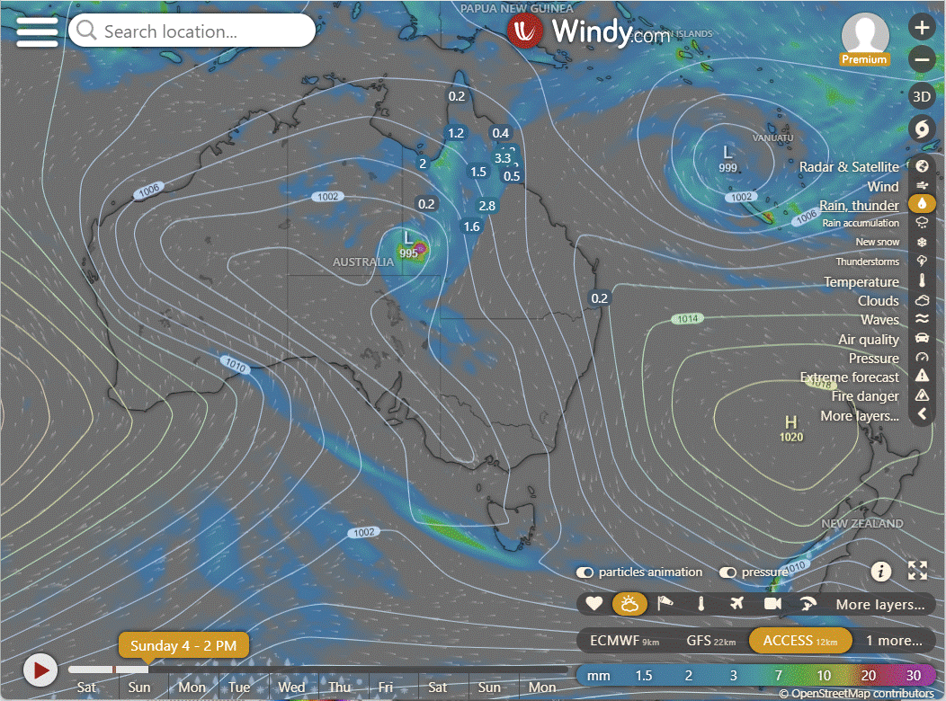
Ex TC Kirrily is still looking healthy, more healthy than 06U out in the Coral Sea. However as Kirrily did, she woke from a deep sleep in the Coral Sea, but at this stage does not look to be repeating the path back to the coast, or at least not yet. And that means no rain for a while. It could be the monsoon pulse has indeed moved on, and the slight stall we expected, was only just a slight stall and not a loop back to our region. All that means is that the monsoon has moved onto the region where Fiji is, and we won't see it back until about March. We do finally have some agreement for 4 days out, so from here on when we look 4 days out we should see where 06U is heading. The water has cooled in the Coral Sea but that is likely due to the cloud cover.

EC | ACCESS | GFS
National
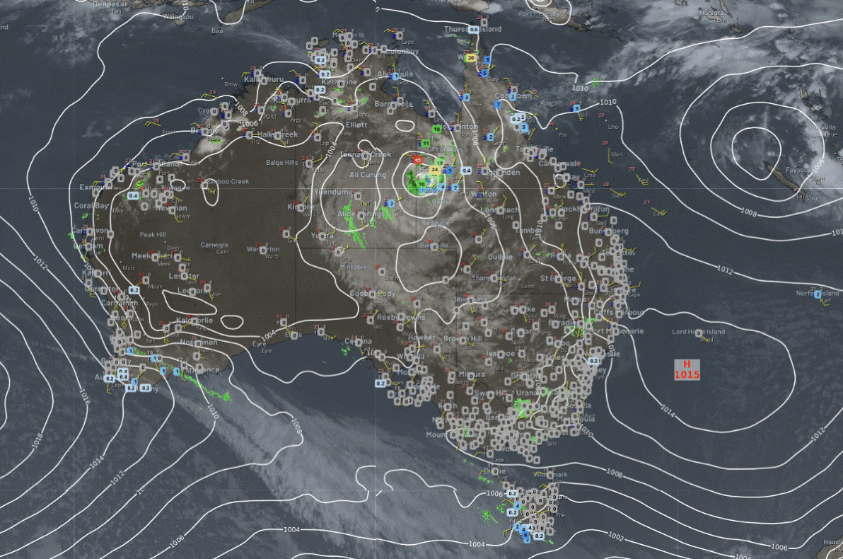
Merging troughs will draw inland heat into SA, VIC, and NSW. A low, along with troughs, will generate rain, showers, and storms over QLD, northeast SA, and northwest NSW, with showers and storms in the northern tropics. A trough should bring gusty showers to TAS.
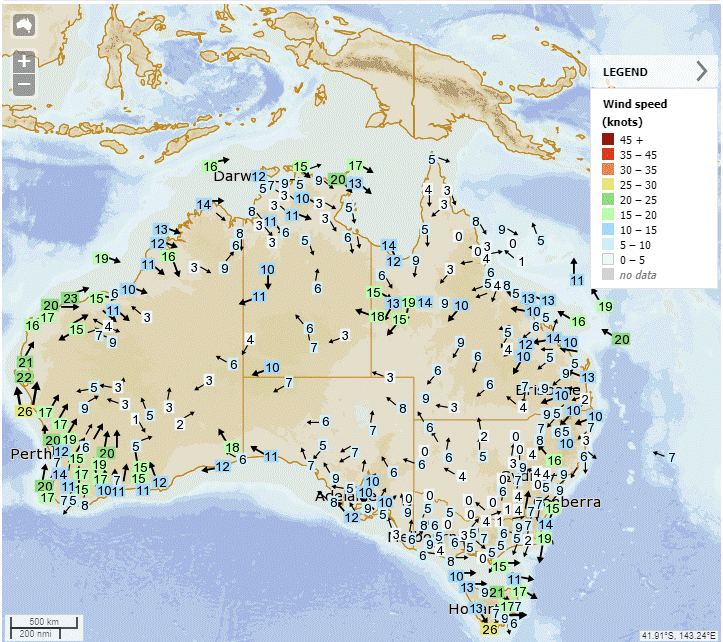
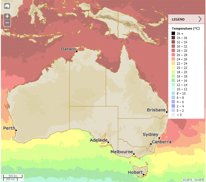
Synoptic | Temp/Rain | Wind | Sea Surface Temp
State
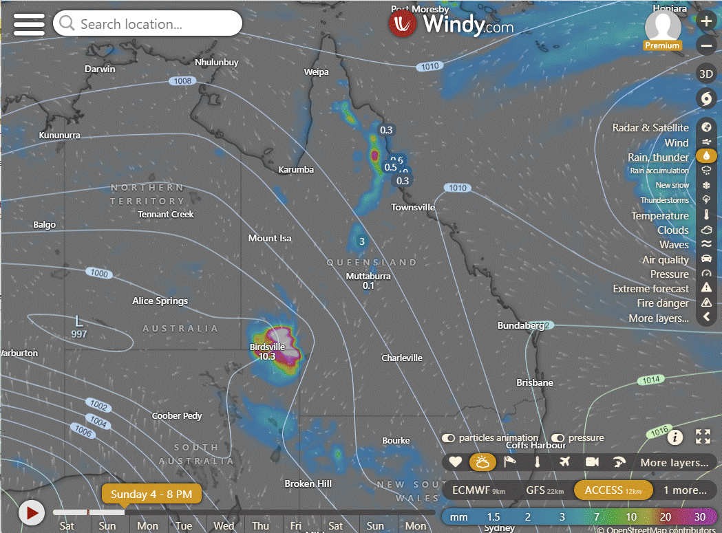
Ex-Tropical Cyclone Kirrily near NT border, moving south crossing QLD on Sun, into NSW on Mon. Weakening trough in N QLD, weak trough in C & S QLD on Tue, highs moving east bringing ridge over SE QLD. Low in Coral Sea staying offshore, may approach QLD coast next week.

ACCESS (Values are rainfall over 3 hours)
4-day
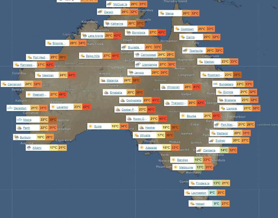
Sunday: Scattered showers and storms in western, northern, and far northern Queensland. Rain and possible heavy wind near Mount Isa from ex-Tropical Cyclone Kirrily. Partly cloudy in the southeast, mostly clear elsewhere. Light to moderate winds, strong in the far west. Winds shifting east to southeast along the east coast.
Monday: Possible showers and thunderstorms in the west, with widespread rain in the far southwest. Chance of severe thunderstorms with heavy rain and strong winds in the southwest. Partly cloudy in the southeast, mostly sunny elsewhere. Temperatures below average in the far southwest, near average north of Hughenden, and above average elsewhere.
Tuesday: Today's weather: Isolated showers and thunderstorms west of Mackay and Roma, showers scattered to isolated north of Hughenden, and widespread over Cape York Peninsula. Isolated showers at the southeast coast. Partly cloudy elsewhere. Maximum temperatures above average, except for below average in the far southwest and near average north of Hughenden.
Wednesday: Some showers and thunderstorms across the state, showers only in the southeast. Cooler in the far southwest, warmer elsewhere.


North Tropical Coast and Tablelands:
Max temperature: 33, Min temperature: low to mid 20s, Wind speed: light, Wind direction: not specified, Rainfall: High chance of showers, Thunderstorm possible, Other: Partly cloudy
Herbert and Lower Burdekin:
Max temperature: low to mid 30s; Min temperature: low to mid 20s; Wind speed: Light, becoming northeasterly 15 to 20 km/h in the late afternoon; Wind direction: Northeasterly; Rainfall: Partly cloudy, high chance of showers in the north, slight chance elsewhere; Other: Chance of a thunderstorm.
Central Coast and Whitsundays:
Max temperature: low to mid 30s, min temperature: low to mid 20s, wind speed: light, wind direction: east to northeasterly, rainfall: none, weather: partly cloudy.
Peninsula:
Max temperature: low to mid 30s, Min temperature: mid 20s, Wind speed: light winds becoming northwest 15-20 km/h in the middle of the day and then light in the evening, Rainfall: medium chance of showers, Other: partly cloudy with a chance of thunderstorm.
Gulf Country:
Max temperature: low to high 30s | Min temperature: mid 20s | Wind speed: 20 to 30 km/h | Wind direction: north to northwesterly | Rainfall: High chance of showers in the east, medium chance elsewhere | Other: Partly cloudy, chance of a severe thunderstorm.
Northern Goldfields and Upper Flinders:
Max temperature: low to mid 30s, Min temperature: low to mid 20s, Wind speed: 15-30 km/h, Wind direction: north to northeasterly, Rainfall: partly cloudy with medium chance of showers, most likely in afternoon and evening, chance of thunderstorm.
Capricornia:
Max temperature: low to mid 30s, Min temperature: low to mid 20s, Wind speed: easterly 15 to 20 km/h becoming light before dawn, Wind direction: east to northeasterly 15 to 25 km/h in the morning, Rainfall: none, Weather: Mostly sunny.
Central Highlands and Coalfields:
Maximum temperature in the mid to high 30s, minimum temperature in the low 20s, wind speed northeast 15-20 km/h becoming light, winds becoming northeast 15-20 km/h, mostly sunny with overnight temperatures falling.
Central West:
Max temperature: 40°C, Min temperature: low to high 20s, Wind speed: 15 to 40 km/h, Wind direction: NE to N, Rainfall: Medium chance of showers west of Longreach, slight chance elsewhere, Other: Partly cloudy, chance of thunderstorm.
North West:
Max temperature: low to mid 30s, Min temperature: low to mid 20s, Wind speed: 25 to 45 km/h, Wind direction: north to northwesterly, Rainfall: medium chance of showers, Thunderstorm: possible and severe, Heavy falls: possible in southwest, Damaging winds: possible in southwest.
Channel Country:
Max temperature: 41, Min temperature: 24, Wind speed: 25-40 km/h, Wind direction: North to northeasterly, Rainfall: Heavy falls possible, Other: Partly cloudy, Very high chance of rain, Chance of thunderstorm, Possible damaging winds.
Maranoa and Warrego:
Max temperature: 43, Min temperature: 23, Wind speed: 25-35 km/h, Wind direction: North to northeasterly, Rainfall: Near zero chance, Other: Mostly sunny with slight chance of a shower near NSW border and chance of thunderstorm in the west.
Darling Downs and Granite Belt:
Maximum temperature: 34 to 39, Minimum temperature: 20 to 25, Wind speed: 15 to 25 km/h from the northeast, Rainfall: None, Weather: Mostly sunny.
Wide Bay and Burnett:
The maximum temperature is in the low to mid 30s with minimum temperature in the low 20s, wind speed becoming easterly 15 to 20 km/h, light winds in the evening, and a chance of rainfall with partly cloudy skies.
Southeast Coast:
Maximum temperature: low 30s, minimum temperature: low 20s, wind speed: light, wind direction: east to northeasterly, rainfall: slight chance of a shower near southern border ranges, overnight temperatures falling to low 20s.
WEATHER WARNINGS
Severe Weather Warning (Heavy, Locally Intense Rainfall And Damaging Winds) for parts of North East Pastoral district.
Strong Wind Warning for Perth Local Waters & Gascoyne, Geraldton, Lancelin, Perth, and Bunbury Geographe coasts.
Severe Weather Warning (Heavy, Locally Intense Rainfall And Damaging Winds) for parts of Barkly and Simpson districts.
Severe Weather Warning (Heavy, Locally Intense Rainfall And Damaging Winds) for parts of North West and Channel Country.
Hazardous Surf Warning for Byron, Coffs, Macquarie, Hunter, Sydney, Illawarra, Batemans, and Eden coasts.
Fire Weather Warning for Eastern Eyre Peninsula, Mid North, Mount Lofty Ranges, Yorke Peninsula, Murraylands, and Upper South East.
Strong Wind Warning for Sunday for Coffs, Macquarie, Hunter, Sydney, Illawarra, Batemans, and Eden coasts.
Strong Wind Warning Sunday for Spencer Gulf, Gulf St Vincent, Adelaide Metropolitan Waters & Far West, Upper West, Lower West & Central coasts.
Gale Warning SE & SW coasts. Strong Wind Warning Banks St & Franklin Sound, East of Flinders Is, SW Lakes & Upper East & CW coasts.
Fire Weather Warning for Mallee and Wimmera.
Moderate Flood Warning For The Diamantina River.
Minor Flood Warning For The Thomson And Barcoo Rivers And Cooper Creek.
Moderate Flood Warning For The Paroo River (Qld).
Flood Watch For Parts Of The Carpentaria Coast, Eastern And Central Inland.
Flood Watch For Far West Of New South Wales.
Major Flood Warning For The Condamine And Balonne Rivers.
Moderate Flood Warning For The Nicholson River And Flood Warning For The Leichhardt River.
Final Flood Watch For Parts Of The Gulf Of Carpentaria And Western Queensland.
Moderate Flood Warning For The Georgina River And Minor Flood Warning For The Eyre Creek.
Moderate Flood Warning For The Moonie River.
Final Flood Warning For The Daly River.
Minor Flood Warning For The Dawson And Connors And Isaac Rivers.
Major Flood Warning For The Flinders River And Minor Flood Warning For The Cloncurry River.
Fire Weather Warning for Midwest Coast, Midwest Inland, and Mortlock.
Minor Flood Warning For The Bulloo River.
Minor Flood Warning For The Paroo River (Nsw).
Minor Flood Warning For The Lower Warrego River (Qld).

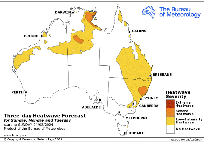
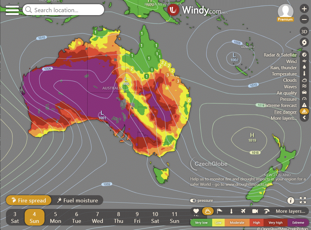
Storms - Heatwave - Fire danger
Click here to support to Wally's Weather
National maps by Weatherzone (weatherzone.com.au)
State maps by Windy (Windy.com)
Weather forecast supplemented by Bureau of Meteorology (bom.gov.au)
Rainfall daily totals (https://meteologix.com/ )
AccuWeather (https://www.accuweather.com/)
Nine Weather (https://www.9news.com.au/weather)
Wally's Weather provides professionally researched data and information. Andrew aka 'Wally' has over 20 years of experience in meteorology research and data analysis. In 2023 finished top 4 for the AMOS national weather forecasting competition. The content here is provided as educational information aimed at providing the community and businesses with the tools required to determine local-based forecasts. IMPORTANT: The forecasts and information posted should never be used on their own to make business decisions as local influences.


Comments