Morning Weather - January 12 - Wally's Weather Australia
- Jan 11, 2024
- 5 min read
This weather update is brought to you by Genesis Electrical NQ

Genesis Electrical NQ
We can Solve all of your Electrical, Air Conditioning and Solar needs!
Phone: 1300 443 637
Email: info@genesislec.com
National
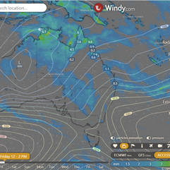
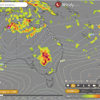
Tropical lows expected to form along the monsoon trough, bringing heavy rain and storms to the northern tropics. Other troughs will drive showers and storms across central and southern WA, the interior, and eastern Australia. Heat drawn southward as troughs influence the weather pattern.

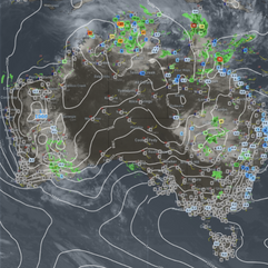


Synoptic | Temp/Rain | Wind | Sea Surface Temp
State
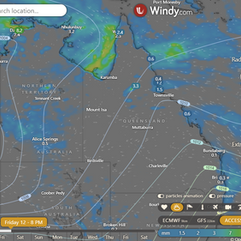
East coast ridge strengthens, extends to Queensland. Southeasterly wind surge moves north. New high maintains ridge. Monsoon trough extends over Cape York. Tropical low may form in Gulf of Carpentaria.


ACCESS 3Hour Rainfall
4-day
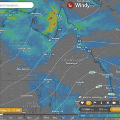
Friday: Thursday: Showers and thunderstorms spread across north and northwest, becoming isolated elsewhere. Severe thunderstorms likely in the north, far north, and west. Heavy rainfall possible along the east coast. Winds to shift from northeast to northwest.
Saturday: Saturday will have showers and thunderstorms in some areas, with heavy rainfall possible in the Gulf Country District and Cape York Peninsula. The central and southern interior will be mostly sunny. Maximum temperatures will be below average in the northwest and near average elsewhere.
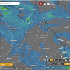
Sunday: Sunday: Scattered showers, periods of rain, and chance of thunderstorm in far northwest. Isolated to scattered showers in eastern districts, south of Cairns. Chance of thunderstorm between St Lawrence and Kingaroy. Moderate to heavy rainfall possible in northwest. Mostly sunny in central and southern interior. Max temperatures below average in northwest, near average elsewhere.
Monday: Potential for rain and thunderstorms in northwest, especially with heavy rainfall. Chance of showers and thunderstorms throughout. Cooler temperatures in the northwest, average elsewhere.


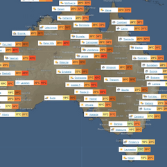
North Tropical Coast and Tablelands:
Max temperature: 31, Min temperature: 19, Wind speed: 15-25 km/h (easterly), Wind direction: east to southeasterly, Rainfall: Very high chance of rain, Other: Cloudy with chance of severe thunderstorm.
Herbert and Lower Burdekin:
Max temperature: 30°C, Min temperature: mid 20s, Wind speed: light becoming easterly 20-30 km/h, Wind direction: east, Rainfall: medium chance of showers, Partly cloudy with a chance of thunderstorm.
Central Coast and Whitsundays:
Max temperature: low 30s, Min temperature: low to mid 20s, Wind speed: 20 to 30 km/h (east to southeasterly), Rainfall: High chance of showers (along coastal fringe), Medium chance elsewhere, Other: Partly cloudy with chance of a thunderstorm.
Peninsula:
The maximum temperature is around 30 with minimum temperatures falling to the low to mid 20s, windy with light winds becoming east to northeasterly 15 to 20 km/h and a very high chance of rain and chance of a thunderstorm, cloudy.
Gulf Country:
Max temperature: low 30s, Min temperature: mid 20s, Wind speed: light becoming east to northeasterly 20 to 30 km/h in the morning then becoming light in the evening, Wind direction: east to northeasterly, Rainfall: very high chance of showers, Other: partly cloudy with the chance of a severe thunderstorm.
Northern Goldfields and Upper Flinders:
Maximum temperature of 36, minimum temperature of 19, wind speed of 25 to 35 km/h, easterly wind direction, medium chance of showers in the north and slight chance elsewhere, possible severe thunderstorm, and partly cloudy.
Capricornia:
Max temperature: low to mid 30s; Min temperature: 19-23; Wind speed: 20-30 km/h from southeasterly direction; Rainfall: Partly cloudy with medium chance of showers near the coast, slight chance elsewhere; Thunderstorm possible.
Central Highlands and Coalfields:
Max temperature: low to mid 30s, Min temperature: 19-22, Wind speed: easterly 20-30 km/h becoming light in the late evening, Wind direction: easterly, Rainfall: Slight chance of shower in the northeast, near zero chance of rain elsewhere, Other: Mostly sunny, chance of thunderstorm in the afternoon and evening.
Central West:
Max temperature: low to high 30s, Min temperature: low 20s, Wind speed: 25 to 35 km/h, Wind direction: east to northeasterly, Rainfall: slight chance of a shower in the southwest, near zero chance elsewhere, other: mostly sunny with a chance of a thunderstorm in the afternoon and evening.
North West:
Max temperature: 33 to 38, Min temperature: low to mid 20s, Wind speed: east to northeasterly 15 to 20 km/h becoming easterly 25 to 35 km/h, Wind direction: northwest with chances of showers, Rainfall: high chance of showers in the northwest, medium chance elsewhere, Other: partly cloudy with a chance of a severe thunderstorm.
Channel Country:
Max temperature: 36 to 41, Min temperature: mid to high 20s, Wind speed: 20 to 30 km/h, Wind direction: east to northeasterly, Rainfall: High chance of showers near NSW border, slight chance elsewhere, Other: Partly cloudy, chance of thunderstorm possibly severe.
Maranoa and Warrego:
Max temperature: low to mid 30s, Min temperature: 20 to 25, Wind speed: easterly 20 to 30 km/h, Wind direction: east, Rainfall: slight chance of a shower in the southwest, most likely from late morning, Other: mostly sunny with a chance of thunderstorm from late morning.
Darling Downs and Granite Belt:
Maximum temperature: 36, Minimum temperature: 17, Wind speed: easterly 25 to 35 km/h, Wind direction: easterly, Rainfall: slight chance of shower, Mostly sunny, Chance of thunderstorm in the north.
Wide Bay and Burnett:
Max temperature: 30, Min temperature: 18-22, Wind speed: 20-30 km/h, Wind direction: southeasterly, Rainfall: partly cloudy with high chance of showers and chance of thunderstorm
Southeast Coast:
Max temperature: 30, Min temperature: 18-22, Wind speed: 25-35 km/h SE, Wind direction: SE, Rainfall: High chance of showers, Partly cloudy, Thunderstorm possible coastal.
WEATHER WARNINGS
Initial Minor Flood Warning issued for the Warrego River (NSW).
Strong Wind Warning for various coastal areas in Western Australia, including Pilbara Coast West, Perth Local Waters & Ningaloo, Gascoyne, Perth, Bunbury Geographe, Leeuwin, and Eucla coasts.
Severe Thunderstorm Warning for damaging winds and heavy rainfall in parts of Upper Western.
Minor Flood Warning issued for the Tully River.
Severe Thunderstorm Warning for damaging winds and heavy rainfall in parts of Central West, Channel Country, and Maranoa and Warrego.
Minor Flood Warning for the Mulgrave and Russell Rivers.
Flood Warning for the Diamantina River.
Final Flood Warning for the Pioneer River.
Strong Wind Warning for Sunshine Coast Waters & Fraser Island Coast on Friday.
Strong Wind Warning for Far West, Upper West, and Lower West coasts on Friday.
Initial Minor Flood Warning for the Seven Creeks.
Moderate Flood Warning for the Goulburn River.
Minor Flood Warning for the Paroo River (NSW).
Minor Flood Warning for the Barcoo River.
Final Flood Warning for the Bunyip River.
Final Flood Warning for the Dandenong Creek.
Major Flood Warning for the Paroo River (QLD).
Final Flood Warning for the Campaspe River.
Minor Flood Warning for the Bulloo River.
Minor Flood Warning for the Loddon River.
Minor Flood Warning for the Yarra River.
Minor Flood Warning for the Latrobe River.
Minor Flood Warning for the Thomson River.
Final Flood Warning for the Dawson River.


Storms - Heatwave - Fire danger
Click here to support to Wally's Weather
National maps by Weatherzone (weatherzone.com.au)
State maps by Windy (Windy.com)
Weather forecast supplemented by Bureau of Meteorology (bom.gov.au)
Rainfall daily totals (https://meteologix.com/ )
AccuWeather (https://www.accuweather.com/)
Nine Weather (https://www.9news.com.au/weather)
Wally's Weather provides professionally researched data and information. Andrew aka 'Wally' has over 20 years of experience in meteorology research and data analysis. In 2023 finished top 4 for the AMOS national weather forecasting competition. The content here is provided as educational information aimed at providing the community and businesses with the tools required to determine local-based forecasts. IMPORTANT: The forecasts and information posted should never be used on their own to make business decisions as local influences.


Comments