Morning Weather - January 14 - Wally's Weather Australia
- Jan 13, 2024
- 6 min read
This weather update is brought to you by Genesis Electrical NQ

Genesis Electrical NQ
We can Solve all of your Electrical, Air Conditioning and Solar needs!
Phone: 1300 443 637
Email: info@genesislec.com
Monsoon update
For the next 4 days at least a low on the monsoon trough is moving SSE overland, producing rainfall of around 10 to 30mm an hour in some parts of the Kimberly, Darwin, Arnhem and Katherine regions. Also building in the Gulf but at this stage 5 to 10mm an hour. The trough crosses the coast between Cooktown and Por Douglas, the rain is light at this stage between 2mm to 10mm per hour.
National
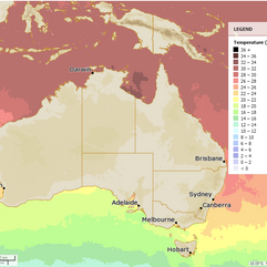
Tropical lows along the monsoon trough continue to bring heavy rain & storms across the tropics. Other troughs, lows & onshore winds drive showers & storms over WA, SA, eastern Qld, NSW, eastern Vic, & Tas while maintaining heat across the interior.


Synoptic | Temp/Rain | Wind | Sea Surface Temp
State
Monsoon trough extends across Gulf of Carpentaria, Cape York Peninsula, Coral Sea. Weak tropical low in trough drifts to Coral Sea by Tuesday, moves east. High pressure ridge extends over central and southern Queensland, moves east. Trough enters southwestern Queensland Wednesday, moves east across southern Queensland Thursday and Friday. Tropical low over Northern Territory may move to central Australia, Northwestern Queensland, then return.


ACCESS 3Hour Rainfall
4-day
Sunday: Scattered showers, isolated thunderstorms, and rain in the far north and northwest. Possible severe thunderstorms with heavy rainfall in those areas. Isolated to scattered showers and thunderstorms in eastern and central districts south of Ingham and in the far west. Mostly clear in the central and southern interior. Light to moderate northeast to southeasterly winds, fresh at times about the southeast coast. Winds turning northwest to northeasterly over northern Cape York Peninsula.
Monday: Scattered showers and isolated thunderstorms in the north and northwest. Potential severe storms with heavy rain in those areas. Showers and a chance of a thunderstorm in the south east and southwest. Partly cloudy elsewhere. Cooler temperatures in the north, near average elsewhere.
Tuesday: Some showers, thunderstorms, and rain in the north and northwest. Possibly severe thunderstorms and heavy rain in those areas. Showers and a chance of thunderstorms in the east (south of Ingham) and southwest. Partly cloudy elsewhere. Temperatures near average.
Wednesday: There will be showers and thunderstorms in different areas. Some severe thunderstorms are possible. Temperatures will be average.


North Tropical Coast and Tablelands:
Max temperature: mid to high 20s; Min temperature: low to mid 20s; Wind speed: light winds becoming east to northeasterly 15 to 20 km/h; Wind direction: east to northeasterly; Rainfall: very high chance of showers, most likely from the late morning; Other: chance of a thunderstorm; Daily temperatures: falling overnight and reaching highs in the mid to high 20s.
Herbert and Lower Burdekin:
Max temperature: 34°C, Min temperature: low to mid 20s, Wind speed: east to northeasterly 15-25 km/h, Wind direction: east to southeasterly, Rainfall: Partly cloudy with a high chance of showers in the north and medium chance elsewhere, and chance of a thunderstorm inland.
Central Coast and Whitsundays:
Max temperature: 35°C, Min temperature: low to mid 20s, Wind: light to easterly 15-25 km/h, Rainfall: medium chance of showers in the south and slight chance elsewhere, Partly cloudy.
Peninsula:
Max temperature: 30°C, Min temperature: low to mid 20s, Wind: Light becoming north to northwesterly 15-20 km/h in early afternoon, Rainfall: Cloudy with very high chance of showers, Chance of thunderstorm.
Gulf Country:
Max temperature: 35, Min temperature: mid 20s, Wind speed: 15 to 25 km/h, Wind direction: east to northeasterly, Rainfall: high chance of showers, Thunderstorm possible, Heavy falls possible near east coast, Cloudy.
Northern Goldfields and Upper Flinders:
Max temperature: 39°C, Min temperature: low to mid 20s, Wind speed: 20 to 30 km/h, Wind direction: east to northeasterly, Rainfall: Very high chance of showers in the north, slight chance elsewhere, Other: Partly cloudy with a chance of thunderstorms.
Capricornia:
Max temperature: low to mid 30s, Min temperature: low to mid 20s, Wind speed: light winds becoming east to southeasterly 15 to 25 km/h, Wind direction: east to southeasterly, Rainfall: Medium chance of showers, most likely in the afternoon and evening, Other: Partly cloudy with a chance of thunderstorm from late morning.
Central Highlands and Coalfields:
Max temperature: low to mid 30s, Min temperature: low 20s, Wind speed: light winds becoming easterly 15 to 25 km/h in the morning, Wind direction: easterly, Rainfall: medium chance of showers, Other: partly cloudy with a chance of a thunderstorm in the east in the afternoon and evening.
Central West:
Max temperature: 35 to 40, min temperature: low to mid 20s, wind speed: 20 to 30 km/h easterly, wind direction: easterly, rainfall: slight chance of a shower, weather: mostly sunny with overnight temperatures falling.
North West:
Max temperature: 35 to 40, Min temperature: mid 20s, Wind speed: easterly 20 to 30 km/h, Wind direction: easterly, Rainfall: Medium chance of showers north of Mt Isa, slight chance elsewhere, Other: Mostly sunny with a chance of thunderstorm in the late morning.
Channel Country:
The max temperature will reach around 40°C with easterly winds of 20-30 km/h. Mostly sunny with a slight chance of a shower near the NSW border and near zero chance of rain elsewhere, but a chance of thunderstorm in the southeast. Overnight temperatures falling to the mid to high 20s.
Maranoa and Warrego:
Temperature: high 30s, low to mid 20s; Wind speed: light to easterly 15-25 km/h; Rainfall: slight chance of a shower near NSW border, near-zero chance of rain elsewhere; Other: thunderstorm possible in the south in afternoon and evening; mostly sunny.
Darling Downs and Granite Belt:
Max temperature of 32 to 38, min temperature of 17 to 23, wind speed of 20 to 30 km/h, wind direction easterly, slight chance of a shower in the east, near zero chance elsewhere, chance of thunderstorms in the southwest in the afternoon and evening.
Wide Bay and Burnett:
Max temperature: 34, Min temperature: 19, Wind speed: 20-30 km/h, Wind direction: east to southeasterly, Rainfall: high chance of showers, Thunderstorm: possible, Other: partly cloudy with winds south to southeasterly 15-20 km/h in the morning.
Southeast Coast:
Max temperature: 30, Min temperature: 18-22, Wind speed: southerly 15-20 km/h to southeasterly 25-35 km/h, Wind direction: Light winds becoming southerly early then tending southeasterly, Rainfall: Partly cloudy with medium chance of showers in the late morning and afternoon, Chance of thunderstorm in the north.
WEATHER WARNINGS
Severe Thunderstorm Warning (Heavy Rainfall) for parts of North Tropical Coast and Tablelands.
Severe Thunderstorm Warning (Damaging Winds And Heavy Rainfall) for parts of Central West and Central Wheat Belt districts.
Strong Wind Warning for Pilbara Coast West & Leeuwin, Albany, Esperance, and Eucla coasts.
Strong Wind Warning for Eden Coast.
Fire Weather Warning for Burrup and Swan Inland South.
Severe Weather Warning (Damaging Winds) Adelaide, Mount Lofty Ranges, Lower Eyre Peninsula, Yorke Peninsula & Kangaroo Island districts.
Severe Weather Warning (Damaging Winds) for Tiwi and parts of Daly and Arnhem districts.
Strong Wind Warning for Central Coast.
Severe Weather Warning (Damaging Winds) for parts of Central, North Central, and Northern Country.
Strong Wind Warning Spencer Gulf, St Vincent, Invest St & Far West, Upper West, Lower West, Central, South Central, Upper SE & L SE coasts.
Moderate Flood Warning For The Goulburn River.
Final Flood Warning For The Daintree And Mossman Rivers.
Minor Flood Warning For The Barcoo River.
Initial Flood Watch For The Cape York Peninsula.
Flood Watch For The North Western Nt.
Final Flood Warning For The Tully River.
Final Flood Warning For The Mulgrave And Russell Rivers.
Minor Flood Warning For The Loddon River.
Minor Flood Warning For The Latrobe River.
Minor Flood Warning For The Seven Creeks.
Minor Flood Warning For The Thomson River.
Fire Weather Warning for Murraylands.
Initial Minor Flood Warning For The Murray River.
Flood Warning For The Diamantina River.
Moderate Flood Warning For The Paroo River (Qld).
Minor Flood Warning For The Paroo River (NSW).
Minor Flood Warning For The Warrego River (NSW).
Minor Flood Warning For The Bulloo River.


Storms - Heatwave - Fire danger
Click here to support to Wally's Weather
National maps by Weatherzone (weatherzone.com.au)
State maps by Windy (Windy.com)
Weather forecast supplemented by Bureau of Meteorology (bom.gov.au)
Rainfall daily totals (https://meteologix.com/ )
AccuWeather (https://www.accuweather.com/)
Nine Weather (https://www.9news.com.au/weather)
Wally's Weather provides professionally researched data and information. Andrew aka 'Wally' has over 20 years of experience in meteorology research and data analysis. In 2023 finished top 4 for the AMOS national weather forecasting competition. The content here is provided as educational information aimed at providing the community and businesses with the tools required to determine local-based forecasts. IMPORTANT: The forecasts and information posted should never be used on their own to make business decisions as local influences.


Comments