Morning Weather - January 17 - Wally's Weather Australia
- Jan 16, 2024
- 6 min read
This weather update is brought to you by Genesis Electrical NQ

Genesis Electrical NQ
We can Solve all of your Electrical, Air Conditioning and Solar needs!
Phone: 1300 443 637
Email: info@genesislec.com
Monsoon update
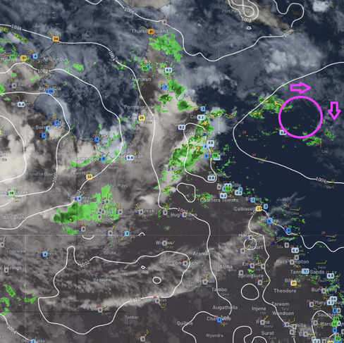
98S has become TC Anggrek, just SW of Jakarta Indonesia. And 99S looks to just remain over land for now and won't deepen into a cyclone just yet. It is still dropping a lot of rain over the top end.
A new low deepening in the Coral Sea is expected to shift away from the QLD coast for several days as the next High moves into play around the 21st. However the next High will be pushed over NZ, have less effect than the one on Jasper and produce less ridging. The system is already further South than Jasper when it developed into a Cyclone and over warmer waters. Add that altogether and initially, it sounds like a more southern crossing than Jasper. That is about all we can say right now.
The main difference is that the amount of warm humid air making it to ex 99S is far greater than the new low in the Coral Sea. so it doesn't have the same feed as Jasper did.


Satellite | Wind
National
The monsoon trough & tropical lows will continue to bring heavy rain & storms across the tropics. Other troughs & a front will continue to drive showers & storms over WA, the NT interior, Qld, Tas & eastern NSW & Vic, whilst maintaining heat through the interior & west.


Synoptic | Temp/Rain | Wind | Sea Surface Temp
State
The monsoon trough will persist for days across the Gulf of Carpentaria, Cape York Peninsula, and the western Coral Sea. A weak tropical low on the trough in the western Coral Sea will move east with uncertain movement from early next week. There is a high-pressure ridge over central and southern Queensland, maintained by a high in the Tasman Sea. The ridge will weaken by Wednesday as the high drifts east. A trough will enter southwestern Queensland on Wednesday, moving east across southern Queensland from Thursday to Friday and weakening over the weekend.


ACCESS 3Hour Rainfall
4-day
Wednesday: Scattered showers, rain at times, and isolated thunderstorms in the Far North and northwest. Showers and thunderstorms in eastern districts. Partly cloudy with isolated storms in the southwest. Northeast to southeasterly winds, fresh at times. Winds turning northwesterly north of Cairns.
Thursday: Thursday: Scattered showers and storms statewide. Showers becoming widespread in Far North and northwest, isolated in Channel Country. Severe thunderstorms possible with heavy rain and damaging winds in northwest and southern interior. Cooler in northwest and Peninsula, warmer elsewhere.
Friday: Scattered rain and storms in the north and northwest, isolated rain and storms elsewhere. Cooler in the northwest, warmer elsewhere.
Saturday: Showers and thunderstorms increasing in northwest, gradually clearing by Sunday. Temperatures near average in the northwest, above average elsewhere.


North Tropical Coast and Tablelands:
Max temperature: 30, Min temperature: mid 20s, Wind speed: light, Wind direction: unspecified, Rainfall: showers likely, Cloudy, Chance of thunderstorm, Low overnight temperatures.
Herbert and Lower Burdekin:
Max temperature: low to mid 30s, Min temperature: low to mid 20s, Wind speed: light becoming east to northeasterly 15 to 20 km/h, Wind direction: east to northeasterly, Rainfall: high chance of showers, most likely from late morning, Other: partly cloudy, chance of thunderstorm.
Central Coast and Whitsundays:
Max temperature: low to mid 30s, Min temperature: low to mid 20s, Wind speed: southeasterly 15 to 20 km/h turning easterly 15 to 25 km/h, Wind direction: easterly, Rainfall: medium chance of showers, mostly in the morning and afternoon, Other: partly cloudy, chance of a thunderstorm.
Peninsula:
Max temperature: low 30s; Min temperature: mid 20s; Wind speed: light; Wind direction: northwesterly; Rainfall: very high chance, most likely in late morning and afternoon; Other: cloudy with chance of severe thunderstorm in the south
Gulf Country:
Max temperature: Low 30s; Min temperature: Mid 20s; Wind speed: Light winds becoming northeasterly 15 to 25 km/h in the morning; Wind direction: Northeasterly; Rainfall: Cloudy with high chance of showers; Other: Chance of severe thunderstorm inland.
Northern Goldfields and Upper Flinders:
The weather will have temperatures ranging from low to mid 20s overnight, with daytime temperatures reaching 30 to 39, accompanied by partly cloudy skies, a high chance of showers in the afternoon and evening, with a possibility of thunderstorms, and winds mainly northeasterly.
Capricornia:
Max temperature: low to mid 30s; Min temperature: low to mid 20s; Wind speed: 15 to 25 km/h; Wind direction: east to northeasterly; Rainfall: medium chance of showers, most likely in late morning and afternoon; Other: partly cloudy, chance of a thunderstorm.
Central Highlands and Coalfields:
Max temperature: low to mid 30s, Min temperature: low to mid 20s, Wind speed: light, Wind direction: east to northeasterly, Rainfall: Partly cloudy with medium chance of showers, chance of a thunderstorm.
Central West:
Max temperature: 41, Min temperature: low to high 20s, Wind speed: 20 to 30 km/h, Wind direction: northeasterly, Rainfall: slight chance of a shower, Other: Partly cloudy, chance of a thunderstorm in afternoon and evening.
North West:
Max temperature: 40, Min temperature: mid to high 20s, Wind speed: 15 to 25 km/h, Wind direction: northeasterly, Rainfall: high chance of showers, Other: Partly cloudy with chance of thunderstorm.
Channel Country:
Max temperature: 43, Min temperature: 30, Wind speed: 15-35 km/h, Wind direction: east to northeasterly to southeast to southwesterly, Rainfall: high chance of showers near NSW border, medium chance elsewhere, Other: partly cloudy with a chance of severe thunderstorm in the south.
Maranoa and Warrego:
Max temperature: mid to high 30s, min temperature: 21 to 27, wind speed: north to northeasterly 20 to 30 km/h, wind direction: northeast to southeasterly 15 to 20 km/h, rainfall: Partly cloudy with high chance of showers near the New South Wales border, medium chance elsewhere, chance of thunderstorm from late morning (possibly severe).
Darling Downs and Granite Belt:
Max temperature: 38, Min temperature: 19, Wind speed: 20-30 km/h NE, Wind direction: NE, Rainfall: Partly cloudy, Medium chance of showers in Granite Belt, slight chance elsewhere, chance of thunderstorm in south, possibly severe.
Wide Bay and Burnett:
Max temperature: low to mid 30s, Min temperature: low 20s, Wind speed: 15 to 25 km/h (e to ne), Rainfall: Partly cloudy with medium chance of showers, Thunderstorm likely in late morning, Light winds becoming east to northeasterly in middle of the day.
Southeast Coast:
The summary for the weather forecast is: Max temperature: 30, Min temperature: 19-22, Wind speed: Light, Wind direction: East, Rainfall: High chance of showers, Partly cloudy.
WEATHER WARNINGS
Severe Thunderstorm Warning (Heavy Rainfall & Damaging Winds) for North West Slopes & Plains, Central West Slopes & Plains & Upper Western.
Strong Wind Warning East of Flinders Is & Far North West, Lower East & South East coasts. Cancelled Fred Hen Bay & Norfolks & Storm Bay.
Strong Wind Warning for East Gippsland Coast.
Strong Wind Warning for Wednesday for Hunter, Sydney, Illawarra, Batemans and Eden coasts.
Severe Thunderstorm Warning (Damaging Winds And Heavy Rainfall) for parts of Great Southern, Central Wheat Belt and Goldfields districts.
Severe Thunderstorm Warning (Heavy Rainfall) for parts of South West, Wimmera and Central.
Gale Warning Leeuwin & Albany coasts. Strong Wind Warning Pilbara E, Pilbara W & North Kimberley & Esperances. Cancelled Bun Geographe.
Initial Minor Flood Warning For The Tweed River.
Severe Weather Warning (Heavy Rainfall & Damaging Winds) for Daly, Tiwi, Arnhem, Gregory & parts of Carpentaria, Barkly & Tanami districts.
Tropical Cyclone Technical Bulletin.
Ocean Wind Warning For Tropical Cyclone.
Tropical Cyclone Advice For Cocos Island And Christmas Island.
Strong Wind Warning for Van Diemen Gulf, Darwin Harbour & Beagle Bonaparte, North Tiwi, Arafura, Gove Peninsula and Roper Groote coasts.
Fire Weather Warning for Burrup and Ashburton Coast.
Severe Weather Warning (Heavy, Locally Intense Rain) Southern Tablelands, South West Slopes, Riverina, Snowy Mountains & ACT.
Severe Weather Warning (Heavy, Locally Intense Rainfall) for North East and parts of East Gippsland and West and South Gippsland.
Strong Wind Warning for South East Gulf of Carpentaria and North East Gulf of Carpentaria.
Minor Flood Warning For The Orara River.
Strong Wind Warning for Wednesday for Spencer Gulf & Lower South East Coast.
Minor Flood Warning For The Bellinger River.
Moderate Flood Warning For The Paroo River (Qld).
Flood Warning For The Murray River.
Moderate Flood Warning For The Bulloo River.
Initial Minor Flood Warning For The Daly River.
Flood Warning For The Victoria River.
Minor Flood Warning For The Herbert River.
Minor Flood Warning For The Barcoo River And Cooper Creek.
Flood Watch For The Cape York Peninsula And Parts Of The Gulf Of Carpentaria.
Flood Watch For The North Western Nt.
Final Flood Warning For The Tully River And Minor Flood Warning For The Murray River.
Minor Flood Warning For The Warrego River (Nsw).
Minor Flood Warning For The Loddon River.
Minor Flood Warning For The Goulburn River.
Minor Flood Warning For The Adelaide River.
Fire Weather Warning for Burrup, Ashburton Coast and Capes.
Flood Warning For The Diamantina River.
Minor Flood Warning For The Paroo River (Nsw).
Final Flood Warning For The Bogan River.


Storms - Heatwave - Fire danger
Click here to support to Wally's Weather
National maps by Weatherzone (weatherzone.com.au)
State maps by Windy (Windy.com)
Weather forecast supplemented by Bureau of Meteorology (bom.gov.au)
Rainfall daily totals (https://meteologix.com/ )
AccuWeather (https://www.accuweather.com/)
Nine Weather (https://www.9news.com.au/weather)
Wally's Weather provides professionally researched data and information. Andrew aka 'Wally' has over 20 years of experience in meteorology research and data analysis. In 2023 finished top 4 for the AMOS national weather forecasting competition. The content here is provided as educational information aimed at providing the community and businesses with the tools required to determine local-based forecasts. IMPORTANT: The forecasts and information posted should never be used on their own to make business decisions as local influences.


Comments