Morning Weather - January 7 - Wally's Weather Australia
- Jan 6, 2024
- 5 min read
This weather update is brought to you by Genesis Electrical NQ

Genesis Electrical NQ
We can Solve all of your Electrical, Air Conditioning and Solar needs!
Phone: 1300 443 637
Email: info@genesislec.com
Special report
WEATHER WARNINGS
Severe Thunderstorm Warning - Darwin City And Outer Darwin (Heavy Rainfall).
Severe Thunderstorm Warning (Damaging Winds, Hail & Heavy Rain) Flinders & E Eyre, Mid North, North West Pastoral & NE Pastoral districts.
Severe Thunderstorm Warning (Heavy Rainfall) for parts of Daly district.
Downy Mildew Advice for Mid North, Mount Lofty Ranges, Riverland, Murraylands, Upper South East, and Lower South East.
Severe Weather Warning (Heavy, Locally Intense Rain) South West Slopes, Riverina, Snowy Mountains, Southern Tablelands & CW Slopes & Plains.
Severe Weather Warning (Heavy, Locally Intense Rainfall) for North East and parts of Northern Country, North Central and East Gippsland.
Strong Wind Warning for East Gippsland Coast.
Strong Wind Warning for Sunday for East of Flinders Island & Far North West and Lower East coasts.
Strong Wind Warning for Sunday for Hunter, Sydney, Illawarra, Batemans, and Eden coasts.
Flood Watch For Central And Northern Victoria.
Final Flood Warning For The Loddon River.
Final Flood Warning For The Seven And Castle Creeks.
Minor Flood Warning For The Avoca River.
Minor Flood Warning For The Dawson River And Final Flood Warning For The Isaac River.
Final Flood Warning For The Paroo River (Nsw).
Final Flood Watch For Parts Of Capricornia And South East Coast.


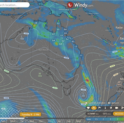
Peak of the storms - 3PM National, State and movement.
National
Troughs and a low will drive showers and storms over SA's east, Vic, Tas, NSW, QLD, and the tropical north, with the heaviest precipitation expected over NSW. Heat will persist over the interior and west regions. Onshore winds are anticipated to bring some showers over the east coast of QLD.


Synoptic | Temp/Rain | Wind | Sea Surface Temp
State
A trough in western Queensland will deepen and move east, bringing more showers and thunderstorms. It will weaken by Wednesday. A ridge along the east coast will strengthen briefly before weakening. There are signs of a monsoon trough forming in the Arafura Sea.


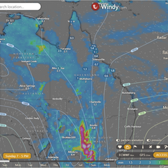


ACCESS 3Hour Rainfall
4-day
Sunday: Scattered showers and isolated thunderstorms throughout most of the state. Showers expected along east coast north of Townsville and southeast coast. Severe thunderstorms possible in southern interior and far southwest. Northeast to southeasterly winds, turning northwest to northeasterly in the west. Strong winds along east coast south of Yeppoon.
Monday: Isolated showers and thunderstorms in most of the state, with only showers in the southeast and east coast between Cooktown and Townsville. Showers widespread in the northwest, central, and southern interior. Morning showers along the east coast between Bowen and Innisfail. Possible severe thunderstorms with heavy rainfall in the southwest. Heatwave conditions easing in the far north. Below average maximum temperatures in the west and southern and central interior, near average elsewhere.
Tuesday: Scattered showers and thunderstorms across most of the state, with isolated showers in the far southwest and only showers on the east coast between Cooktown and Ingham. Showers widespread at times on the western Cape York Peninsula, northern, central, and southern interior, and along the east coast between Bowen and Innisfail. Possible severe thunderstorms with heavy rainfall in the southern interior. Max temperatures below average in the west and central and southern interior, near average elsewhere.
Wednesday: Scattered showers and thunderstorms across the state, mainly along the Gulf of Carpentaria coast, northern interior, and inland Far North Queensland. Occasional widespread showers along the east coast between Bowen and Innisfail. Below average temperatures in the west and central/southern interior, near average elsewhere.


North Tropical Coast and Tablelands:
Max temperature: 34, Min temperature: 20, Wind speed: light, Wind direction: easterly, Rainfall: showers, Other: Partly cloudy with a chance of thunderstorm inland.
Herbert and Lower Burdekin:
Max temperature: low to mid 30s, Min temperature: low to mid 20s, Wind speed: light becoming 15 to 25 km/h, Wind direction: east to northeasterly, Rainfall: High chance of showers near the coast, medium chance elsewhere, Other: Partly cloudy with chance of thunderstorm inland.
Central Coast and Whitsundays:
The max temperature will be 34, the min temperature will be in the low to mid 20s, wind speed will be light, wind direction will start as easterly then become light, there is a high chance of showers, most likely in the morning and afternoon, and a chance of thunderstorm inland.
Peninsula:
Max temperature: 39, Min temperature: mid 20s, Wind speed: light becoming 15-25 km/h, Wind direction: east to northeasterly, Rainfall: high chance of showers, Thunderstorm: possible, Partly cloudy with temperatures reaching 33 to 39.
Gulf Country:
Max temperature: mid to high 30s; Min temperature: mid to high 20s; Wind speed: light becoming northerly 15 to 20 km/h; Wind direction: N; Rainfall: High chance of showers; Other: Partly cloudy, chance of thunderstorm.
Northern Goldfields and Upper Flinders:
Max temperature: 33 to 38, Min temperature: low to mid 20s, Wind speed: 15 to 25 km/h, Wind direction: east to northeasterly, Rainfall: Partly cloudy with a medium chance of showers in the west and slight chance elsewhere, Chance of thunderstorm.
Capricornia:
The forecast includes a max temperature in the low to mid 30s, a min temperature between 19 and 23, southeasterly winds turning easterly, a medium chance of showers, and partly cloudy conditions.
Central Highlands and Coalfields:
Max temperature: low to mid 30s, Min temperature: low 20s, Wind: east to northeasterly 15 to 20 km/h becoming light before dawn then becoming east to northeasterly 15 to 25 km/h in the morning, Rainfall: Partly cloudy with medium chance of showers and chance of a thunderstorm.
Central West:
The weather will be partly cloudy with a medium chance of showers and a chance of severe thunderstorms. Winds will be northeasterly at 25-35 km/h. Temperatures will range from the low to mid 20s overnight to 34-39 during the day.
North West:
Max temperature: mid to high 30s; Min temperature: mid 20s; Wind speed: light winds becoming north to northwesterly 15 to 20 km/h in the morning then becoming light in the evening; Wind direction: unknown; Rainfall: high chance of showers, most likely from late morning; Other: partly cloudy, chance of a thunderstorm, possibly severe.
Channel Country:
Max temperature: mid to high 30s, Min temperature: mid to high 20s, Wind speed: 25-35 km/h, Wind direction: north to northeasterly, Rainfall: Partly cloudy with high chance of showers and possibility of severe thunderstorm and heavy falls in southeast.
Maranoa and Warrego:
Max temperature: low to mid 30s, Min temperature: 20 to 26, Wind speed: northeasterly 15 to 25 km/h tending north to northeasterly 25 to 35 km/h, Wind direction: north to northeasterly, Rainfall: Partly cloudy with high chance of showers in the west and medium chance elsewhere, Chance of a severe thunderstorm, Overnight temperatures falling to 20 to 26.
Darling Downs and Granite Belt:
Max temperature: 35, Min temperature: 16, Wind speed: 35, Wind direction: east to northeasterly, Rainfall: none.
Wide Bay and Burnett:
Max temperature: 30°C, Min temperature: 17-21°C, Wind speed: SE 15-20 km/h turning E 15-25 km/h, Rainfall: Partly cloudy, Medium chance of showers coastal, slight chance elsewhere.
Southeast Coast:
Max temperature: 30, Min temperature: 16-20, Wind speed: 15-25 km/h, Wind direction: east to southeasterly, Rainfall: slight chance of shower in the morning, Other: Partly cloudy.
Click here to support to Wally's Weather
National maps by Weatherzone (weatherzone.com.au)
State maps by Windy (Windy.com)
Weather forecast supplemented by Bureau of Meteorology (bom.gov.au)
Rainfall daily totals (https://meteologix.com/ )
AccuWeather (https://www.accuweather.com/)
Nine Weather (https://www.9news.com.au/weather)
Wally's Weather provides professionally researched data and information. Andrew aka 'Wally' has over 20 years of experience in meteorology research and data analysis. In 2023 finished top 4 for the AMOS national weather forecasting competition. The content here is provided as educational information aimed at providing the community and businesses with the tools required to determine local-based forecasts. IMPORTANT: The forecasts and information posted should never be used on their own to make business decisions as local influences.


Comments