Morning Weather - January 8 - Wally's Weather Australia
- Jan 7, 2024
- 5 min read
This weather update is brought to you by Genesis Electrical NQ

Genesis Electrical NQ
We can Solve all of your Electrical, Air Conditioning and Solar needs!
Phone: 1300 443 637
Email: info@genesislec.com
National
Troughs will drive heavy showers and storms over the tropical north, QLD, central NSW, and eastern Vic, with the heaviest precipitation expected over NSW and Vic. Troughs will also maintain heat across the interior and west. A high-pressure ridge should keep much of Tas, SA, and WA's south dry and settled.


Synoptic | Temp/Rain | Wind | Sea Surface Temp
State
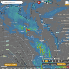
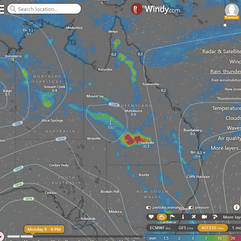
A trough in western Queensland deepens and moves slowly east, bringing more showers and thunderstorms. It weakens over the Southern Inland on Wednesday. The east coast ridge weakens starting Monday but could strengthen again later in the week. The monsoon trough could develop in the Arafura Sea and extend into the Gulf of Carpentaria and Torres Strait next weekend.


ACCESS 3Hour Rainfall
4-day
Monday: Most of the state will have scattered showers and thunderstorms, but areas in the southeast and east coast will mostly have showers. The southwest will experience periods of rain, and there is a chance of severe thunderstorms with heavy rainfall in western Queensland. Winds will be light to moderate from the northeast to southeasterly, changing to northwest to northeasterly in the west.
Tuesday: Scattered showers and thunderstorms across the state, isolated in some areas. Showers more widespread in certain regions. Possible severe thunderstorms with heavy rainfall in parts of Queensland. Below average temperatures in the west and central/southern interior, near average elsewhere.
Wednesday: Scattered showers and thunderstorms mainly in the state, isolated in the far southwest. Showers widespread in Gulf of Carpentaria coast, northern interior and Far North Queensland. Moderate rainfall expected in northern and Far North Queensland. Severe thunderstorms possible in inland southeast Queensland with heavy falls. Below average temperatures in the west and central/southern interior, near average in other areas.
Thursday: Possible showers and thunderstorms throughout most of the state, with heavier falls in northern areas. Below average temperatures in the west, average temperatures elsewhere.


North Tropical Coast and Tablelands:
Max temperature: 34, Min temperature: 20-25, Wind speed: 15-25 km/h, Wind direction: East to northeasterly, Rainfall: Partly cloudy with medium chance of showers in the late morning and afternoon, Thunderstorm inland, Light winds becoming east to northeasterly 15-25 km/h in the middle of the day then becoming light in the evening.
Herbert and Lower Burdekin:
Max temperature: 30 to 35, Min temperature: low to mid 20s, Wind speed: light becoming 15 to 25 km/h, Wind direction: northeasterly, Rainfall: High chance of showers, Thunderstorm possible, Cloudy with some sun.
Central Coast and Whitsundays:
Max temperature: low to mid 30s, min temperature: low to mid 20s, wind speed: light, wind direction: east to northeasterly, rainfall: medium chance of showers, other: partly cloudy with a chance of thunderstorm in the late morning and light winds.
Peninsula:
Max temperature: 32 to 37, Min temperature: mid 20s, Wind speed: light becoming east to northeasterly 15 to 25 km/h, Wind direction: various, Rainfall: High chance of showers near the west coast, medium chance elsewhere, Other: Partly cloudy with a chance of thunderstorms.
Gulf Country:
Max temperature: mid 30s; Min temperature: mid to high 20s; Wind speed: light, becoming northwest to northeasterly 15 to 20 km/h in the early afternoon then becoming light in the evening; Wind direction: northwest to northeasterly; Rainfall: High chance of showers, most likely from the late morning, with a chance of thunderstorm; Other: Partly cloudy
Northern Goldfields and Upper Flinders:
Max temperature: low to mid 30s, Min temperature: low to mid 20s, Wind speed: north to northeasterly 15 to 20 km/h, Wind direction: tending northwest to southwesterly, Rainfall: chance of showers, most likely in the afternoon and evening, Other: Partly cloudy, chance of thunderstorm.
Capricornia:
Max temperature: low to mid 30s, Min temperature: low to mid 20s, Wind speed: 15 to 25 km/h, Wind direction: east to northeasterly, Rainfall: medium chance of showers, Partly cloudy.
Central Highlands and Coalfields:
Max temperature: low to mid 30s; Min temperature: low 20s; Wind speed: 15 to 20 km/h; Wind direction: east to northeasterly; Rainfall: medium chance of showers in the afternoon and evening; Other: Partly cloudy with chance of thunderstorm in the west.
Central West:
Max temperature: low to mid 30s, Min temperature: low to mid 20s, Wind speed: 20 to 30 km/h becoming light in the early afternoon, Wind direction: north to northeasterly, Rainfall: high chance of rain, Cloudy with chance of thunderstorm.
North West:
Max temperature: low to mid 30s, Min temperature: low to mid 20s, Wind speed: light winds, Wind direction: not specified, Rainfall: very high chance of showers, Other: Partly cloudy, chance of thunderstorm.
Channel Country:
Max temperature: mid to high 30s, Min temperature: mid 20s, Wind speed: 20 to 30 km/h, Wind direction: northwest to northeasterly, Rainfall: Partly cloudy with high chance of showers in the northeast, medium chance elsewhere, Other: chance of severe thunderstorm and winds shifting throughout the day.
Maranoa and Warrego:
Max temperature: 30°C, Min temperature: low to mid 20s°C, Wind speed: turning northerly 20 to 30 km/h, Wind direction: northeasterly, Rainfall: Cloudy with high chance of rain, Thunderstorm possible with gusty winds, hail and heavy falls near New South Wales border in afternoon and evening.
Darling Downs and Granite Belt:
The weather will be partly cloudy, with a chance of showers and thunderstorms, winds shifting from northeasterly to northwest to northeasterly, and temperatures ranging from 17 to the low to mid 30s.
Wide Bay and Burnett:
Max temperature: low to mid 30s, min temperature: 18-22, wind speed: light, wind direction: east to northeasterly 15-20 km/h, rainfall: medium chance of showers, overnight temperatures falling, partly cloudy throughout the day.
Southeast Coast:
Max temperature: 30, Min temperature: 18-21, Wind speed: Light becoming east-northeasterly 15-20 km/h, Wind direction: East-northeast, Rainfall: High chance of showers, Partly cloudy.
WEATHER WARNINGS
Strong Wind Warning for East Gippsland Coast. Cancellation for Port Phillip & Central Coast.
Strong Wind Warning for East of Flinders Island. Cancellation for Lower East Coast.
Severe Thunderstorm Warning (Heavy Rain, Damaging Winds & Large Hail) Riverina, Lower Western, Upper Western & Central West Slopes & Plains.
Severe Thunderstorm Warning (Heavy Rainfall) for parts of Central, Mallee, South West and Northern Country.
Cancellation Of Severe Thunderstorm Warning for Maranoa and Warrego.
Brown Rot Advice Mallee, Wimmera, Northern Country, North Central, North East, South West, Central, West & South Gippsland & East Gippsland.
Severe Thunderstorm Warning (Damaging Winds And Heavy Rainfall) for parts of Simpson and Barkly districts.
Strong Wind Warning Monday Pilbara E, Per Local & Geraldton, Lancelin, Per, Bunbury Geographe & Esperances. Cancelled Monday Leeuwin Coast.
Initial Minor Flood Warning For The Broken River.
Initial Moderate Flood Warning For The King River And Fifteen Mile Creek.
Fire Weather Warning Burrup, Yarra Yarra, Swan Inland North, Swan Inland South, Brockman, Blackwood, Mortlock, Stirling North.
Downy Mildew Advice for Mid North, Mount Lofty Ranges, Riverland, Murraylands, Upper South East, and Lower South East.
Severe Weather Warning (Heavy, Locally Intense Rain) South West Slopes, Riverina, Snowy Mountains, Southern Tablelands & CW Slopes & Plains.
Strong Wind Warning for Hunter, Sydney, Illawarra, Batemans, and Eden coasts.
Flood Watch For Gippsland, Central And Northern Victoria.
Minor Flood Warning For The Dawson River.
Minor Flood Warning For The Avoca River.
Final Flood Watch For Parts Of Capricornia And South East Coast.


Storms - Heatwave - Fire danger
Click here to support to Wally's Weather
National maps by Weatherzone (weatherzone.com.au)
State maps by Windy (Windy.com)
Weather forecast supplemented by Bureau of Meteorology (bom.gov.au)
Rainfall daily totals (https://meteologix.com/ )
AccuWeather (https://www.accuweather.com/)
Nine Weather (https://www.9news.com.au/weather)
Wally's Weather provides professionally researched data and information. Andrew aka 'Wally' has over 20 years of experience in meteorology research and data analysis. In 2023 finished top 4 for the AMOS national weather forecasting competition. The content here is provided as educational information aimed at providing the community and businesses with the tools required to determine local-based forecasts. IMPORTANT: The forecasts and information posted should never be used on their own to make business decisions as local influences.


Comments