

Morning Weather - March 9 - Wally's Weather Australia
- Mar 8, 2024
- 5 min read
To get your daily forecast delivered free goto http://wallysweather.com.au/blog

An added thanks to the sponsorship from NQ Licensed Events and the Country Festival on March 30 & 31 at the Dittman Bullpit

Website: https://www.countryfest.com.au/
Facebook: https://www.facebook.com/contryfestqld
Instagram: https://www.instagram.com/countryfestqld/
Monsoon Update
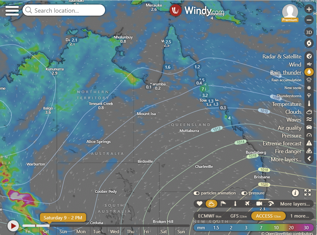
The return of the monsoon update with the monsoon pulse approaching this region. If you have been following the Long Range forecast as a Big Shout supporter you will be well aware of the two systems that have been tracked for weeks and aware of the monsoon pulse since September 2023.
Two areas are being monitored for monsoonal activity, being tropical lows that might develop. One well west of WA in the Indian Ocean and the other a low that should form over the next 4 days just off the coast of the York Peninsula. The models have been consistently showing tropical low activity in these locations but the movements and intensities have been sketchy. The following models are current but only examples to show you where roughly we should start to see low pressure activity form. The last image shows where the pulse of the monsoon is at the moment, West as in the Indian Ocean.


National
Hot northerly winds prevailing over SA, Vic, and western NSW. Increasing rain and storms across the Top End and northeast WA due to a developing monsoon, with rain spreading to southern WA in humid and unstable winds. Onshore winds bringing showers to east Qld and northeast NSW.
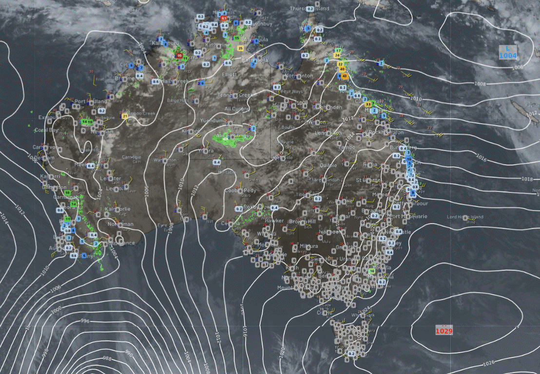
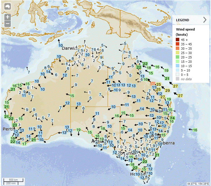

Synoptic | Temp/Rain | Wind | Sea Surface Temp
State
High pressure system brings showers, winds to state's east coast. High will weaken by Tuesday. Increased rainfall possible over weekend due to trough. Monsoon trough may develop next week with potential for tropical lows.


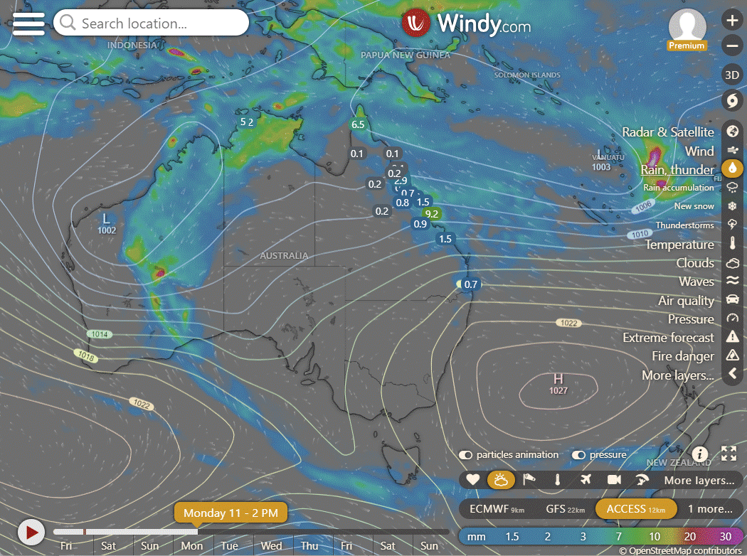
ACCESS (Values are rainfall over 3 hours)
4-day
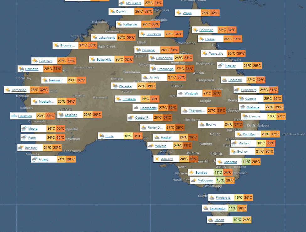
Saturday: Patchy showers and isolated thunderstorms in north of Mackay, chance of heavy rain. Some showers in far eastern districts south of Mackay. Showers increasing on North Tropical Coast. Mostly sunny elsewhere. Light to moderate northeast to southeasterly winds, fresh on east coast.
Sunday: Sunday's weather: Showers in some areas, thunderstorms possible in the north. Rain may be heavy in the North Tropical Coast. Sunny in most places. Temperature variance across regions.
Monday: Spotty showers northeast, isolated thunderstorms north, showers becoming widespread North Tropical Coast, mostly sunny elsewhere, above average temps in far southwest, near average elsewhere.
Tuesday: Sunny in most areas, with showers in the northeast and north. Warmer in the southwest.


North Tropical Coast and Tablelands:
Max temperature: 32°C, Min temperature: 20°C, Wind speed: 20 to 30 km/h, Wind direction: East to southeasterly, Rainfall: High chance of showers, Chance of thunderstorm, Weather: Cloudy with heavy falls possible.
Herbert and Lower Burdekin:
Max temperature: around 30, Min temperature: low to mid 20s, Wind speed: 20 to 30 km/h easterly to southeasterly, Wind direction: east to southeast, Rainfall: High chance of showers, Cloud: Cloudy with a chance thunderstorm.
Central Coast and Whitsundays:
Max temperature: 32°C, Min temperature: 20°C, Wind speed: 25-35 km/h, Wind direction: Southeasterly, Rainfall: Medium chance of showers, Other: Partly cloudy with chance of thunderstorm in the north.
Peninsula:
Temperatures will reach the low to mid 30s, with light winds becoming easterly in the morning and chance of showers and thunderstorms later in the day.
Gulf Country:
Max temperature in the low to mid 30s, min temperature in the mid 20s, winds easterly 15-25 km/h becoming light, high chance of showers in the north, slight chance elsewhere, chance of a thunderstorm, partly cloudy.
Northern Goldfields and Upper Flinders:
The weather forecast for today includes maximum temperature of 35°C, minimum temperature in the low to mid 20s, easterly winds at 25 to 35 km/h, medium chance of showers in the east, near zero chance of rain elsewhere, and partly cloudy conditions with a chance of thunderstorms in the late morning.
Capricornia:
Max temperature: 30°C, min temperature: 19-23°C, wind speed: 20-30 km/h, wind direction: southeasterly, rainfall: slight chance of a shower, other: Partly cloudy.
Central Highlands and Coalfields:
Low 30s, 18-22, easterly 20-30 km/h, Partly cloudy, slight chance of a shower in the northeast, near zero chance elsewhere, falling overnight temperatures.
Central West:
The weather forecast includes temperatures ranging from low to mid 30s, increasing easterly winds of 25 to 35 km/h, and partly cloudy conditions with overnight temperatures falling to the low to mid 20s.
North West:
Max temperature: mid 30s, min temperature: mid 20s, wind speed: easterly 25 to 35 km/h, wind direction: easterly, rainfall: slight chance of a shower near the Northern Territory border, near zero chance elsewhere, other: Partly cloudy with a chance of a thunderstorm near the Northern Territory border.
Channel Country:
The weather forecast includes maximum temperature in the mid to high 30s, minimum temperature in the mid to high 20s, easterly winds at 25 to 35 km/h, no rainfall, and mostly sunny conditions.
Maranoa and Warrego:
Max temperature: low to mid 30s, Min temperature: 18-23, Wind speed: 25 to 35 km/h easterly, Wind direction: Easterly, Rainfall: None, Other: Sunny
Darling Downs and Granite Belt:
The weather will be partly cloudy with a maximum temperature of 35°C, minimum temperature of 18°C, easterly winds at 20 to 30 km/h, and a slight chance of a shower over the Granite Belt, near zero chance elsewhere, along with overnight temperatures falling to around 18.
Wide Bay and Burnett:
Maximum temperature around 30, minimum temperature between 17 and 21, with southeasterly winds at 20 to 30 km/h, partly cloudy with a medium chance of showers along the coastal fringe and a slight chance elsewhere.
Southeast Coast:
Maximum temperature: around 30, Minimum temperature: between 18 and 22, Wind speed: 20 to 30 km/h southeasterly, Wind direction: southeasterly, Rainfall: Medium chance of showers along coastal fringe and in the north, slight chance elsewhere, Other: Partly cloudy.
WEATHER WARNINGS
Fire Weather Warning for West Coast, E Eyre, L Eyre, Mid North, Mt Lofty R, Yorke Peninsula, Kangaroo Island, Murraylands, Upper SE & L SE.
Strong Wind Warning for Hervey Bay & Townsville, Mackay, Capricornia, and K'gari coasts.
Strong Wind Warning for Saturday for Port Phillip & East Gippsland Coast.
Severe Thunderstorm Warning (Heavy Rainfall) for parts of Kimberley district.
Strong Wind Warning for Saturday for Upper East, Lower East, South East, South West & Central West coasts. (Cancelled for Far North West Coast on Saturday.)
Fire Weather Warning for South West and Central.
Initial Moderate Flood Warning For The Daly River.
Moderate Flood Warning For The Paroo River (Qld).
Flood Watch For The East Kimberly, Salt Lake And Nullarbor District Rivers, Sandy Desert And Parts Of The Pilbara Coast Rivers.
Moderate Flood Warning For The Diamantina River.
Minor Flood Warning For The Paroo River (Nsw).
Moderate Flood Warning For The Flinders River.
Strong Wind Warning for Perth Local Waters & Gascoyne, Geraldton, Lancelin, Perth, Bunbury Geographe, Leeuwin, Albany, and Esperance coasts.
Final Flood Warning For The Warrego River (Nsw).
Moderate Flood Warning For Eyre Creek And Minor Flood Warning For The Georgina River.
Flood Watch For The Victoria River Below Kalkarindji, The Katherine, Daly, Fitzmaurice, Moyle, Waterhouse, And East Kimberley Rivers.
Severe Weather Warning (Heavy, Locally Intense Rainfall) for parts of Goldfields, Eucla, and South Interior districts.
Minor Flood Warning For The Mulgrave River And Flood Warning For The Russell River.
Minor Flood Warning For The Katherine River.
Moderate Flood Warning For The Tully River And Minor Flood Warning For The Murray River.
Minor Flood Warning For The Waterhouse River And Flood Warning For The Roper River.
Flood Warning For The Inland Rivers SA.


Storms - Heatwave - Fire danger
Click here to support to Wally's Weather
National maps by Weatherzone (weatherzone.com.au)
State maps by Windy (Windy.com)
Weather forecast supplemented by Bureau of Meteorology (bom.gov.au)
Rainfall daily totals (https://meteologix.com/ )
AccuWeather (https://www.accuweather.com/)
Nine Weather (https://www.9news.com.au/weather)
Wally's Weather provides professionally researched data and information. Andrew aka 'Wally' has over 20 years of experience in meteorology research and data analysis. In 2023 finished top 4 for the AMOS national weather forecasting competition. The content here is provided as educational information aimed at providing the community and businesses with the tools required to determine local-based forecasts. IMPORTANT: The forecasts and information posted should never be used on their own to make business decisions as local influences.


Comments