Morning Weather - May 3 - Wally's Weather Australia
- May 2, 2024
- 1 min read
To get your daily forecast delivered free goto http://wallysweather.com.au/blog
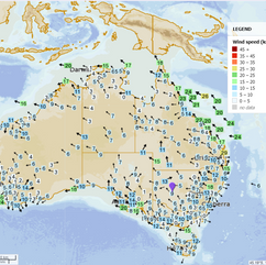
National Unstable atmospheric conditions are likely to bring rain and storms, possibly heavy, to southeastern New South Wales. Moist easterly winds are expected to result in showers over the eastern and northern parts of Queensland. Coastal areas of Victoria can anticipate showers due to onshore winds circulating around a high-pressure system. In Western Australia's southern regions, a few light showers are forecasted as moist winds associated with a low-pressure system between highs prevail. Synoptic | Temp/Rain | Wind | Sea Surface Temp |
The 4 day forecast brought to you by our local businesses, you could have this spot with your details, support local, take out a Bold Shout! $250 for a year, you get this and the website every day! |
4 Day Forecast
|
Warnings
Storms - Extreme Weather - Fire danger |


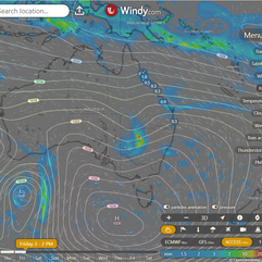


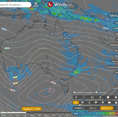


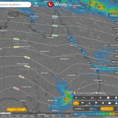
State Strong high pressure system south of Australia brings fresh winds, showers. High moves east, lingers near Tasmania, then moves to Tasman Sea. Developing trough brings unsettled weather over western Queensland. Trough deepens Friday, moves east and off the southeast coast by Sunday. New ridge builds after trough. ACCESS (Values are rainfall over 3 hours) |


State Region Round-up North Tropical Coast and Tablelands: The weather forecast includes a max temperature of 28°C, a min temperature of 16°C, winds ESE at 20-30 km/h, a medium chance of showers mainly in the morning and afternoon, and partly cloudy conditions. Herbert and Lower Burdekin: Max temperature is in the mid to high 20s with light winds becoming east to southeasterly 15 to 20 km/h in the morning, overnight temperatures falling to between 15 and 19, slight chance of a shower in the north, near zero elsewhere, partly cloudy conditions. Central Coast and Whitsundays: Partly cloudy with southeasterly winds at 20-30 km/h, medium chance of showers near the coast, slight chance elsewhere, with daytime temperatures in the mid to high 20s and overnight temperatures dropping to 16-19. Peninsula: The weather will be partly cloudy with a slight chance of a shower near the east coast in the early morning, with winds east to southeasterly at 20 to 30 km/h, no rain elsewhere, and temperatures falling to the low to mid 20s overnight and reaching the low to mid 30s during the day. Gulf Country: The weather will be mostly sunny with temperatures ranging between 19-30s, light east to southeasterly winds of 15-20 km/h, and a chance of overnight temperatures dropping to 19-22. Northern Goldfields and Upper Flinders: The weather will be partly cloudy with easterly winds at 20-30 km/h becoming light later, overnight temperatures dropping to 14-18°C, daytime temperatures reaching 27-32°C, with no significant rainfall expected. Capricornia: Max temperature in the mid to high 20s, min temperature between 14 and 18, southeasterly winds at 15 to 25 km/h, slight chance of a shower with rain most likely in the late morning and afternoon and partly cloudy conditions. Central Highlands and Coalfields: Tomorrow's weather forecast: Max temp: 29°C, Min temp: 11°C, Wind: E to SE 15-25 km/h, Rainfall: Slight chance of shower in SE, Partly cloudy with light winds. Central West: Mostly sunny with daytime temperatures around 30, overnight temperatures falling to between 13 and 16, easterly winds 20 to 30 km/h becoming light in the evening, and no rainfall expected. North West: Maximum temperature: low 30s, Minimum temperature: between 15 and 20, Wind speed: east to southeasterly 15 to 25 km/h becoming light, Wind direction: southeasterly becoming light then returning, Rainfall: Sunny. Winds east to southeasterly 15 to 25 km/h becoming light in the evening then becoming southeasterly 15 to 20 km/h in the late evening. Overnight temperatures falling to between 15 and 20 with daytime temperatures reaching the low 30s. Channel Country: Maximum temperature of 31°C, minimum temperature of 16°C, south to southeasterly winds 15 to 25 km/h, high chance of showers near NSW border, near zero chance of rain elsewhere, chance of a thunderstorm in southeast. Maranoa and Warrego: Max temperature: mid to high 20s, Min temperature: 11-15, Wind speed: 15-25km/h, Wind direction: east to northeasterly, Rainfall: Near zero chance, Other: Partly cloudy with medium chance of showers in the south, most likely in afternoon and evening; chance of a thunderstorm in the south; winds becoming light in the evening. Darling Downs and Granite Belt: Max temperature: 26°C, min temperature: 11°C, wind speed: 15 to 25 km/h easterly, wind direction: east, rainfall: slight chance of shower in southwest but near zero chance elsewhere, other: Partly cloudy. Wide Bay and Burnett: Maximum temperature in the low to mid 20s, minimum temperature between 13 and 18, southeasterly winds 15 to 25 to 25 km/h becoming light, very high chance of showers along the coastal fringe, medium chance elsewhere, and overall cloudy conditions. Southeast Coast: Max temperature: low to mid 20s, Min temperature: 12 to 17, Wind speed: Southerly 15 to 20 km/h, Wind direction: Southeasterly, Rainfall: High chance of showers along the coastal fringe, medium chance elsewhere, Other: Partly cloudy. |
Click here to support to Wally's Weather
National maps by Weatherzone (weatherzone.com.au)
State maps by Windy (Windy.com)
Weather forecast supplemented by Bureau of Meteorology (bom.gov.au)
Rainfall daily totals (https://meteologix.com/ )
AccuWeather (https://www.accuweather.com/)
Nine Weather (https://www.9news.com.au/weather)
Wally's Weather provides professionally researched data and information. Andrew aka 'Wally' has over 20 years of experience in meteorology research and data analysis. In 2023 finished top 4 for the AMOS national weather forecasting competition. The content here is provided as educational information aimed at providing the community and businesses with the tools required to determine local-based forecasts. IMPORTANT: The forecasts and information posted should never be used on their own to make business decisions as local influences.


Comments