Morning Weather - November 13 - Wally's Weather Australia
- Nov 13, 2023
- 3 min read
This weather update is brought to you by Genesis Electrical NQ

Genesis Electrical NQ
We can Solve all of your Electrical, Air Conditioning and Solar needs!
Green Energy Initiative
Phone: 1300 443 637
Email: info@genesislec.com
Storms special report
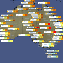
Troughs will cause scattered showers and storms in WA, western SA, and the NT, with a few showers and storms in QLD and northeast NSW, some potentially intense. Troughs will maintain heat over the interior and the east. A front will bring cool gusty showers to TAS. Dry and settled conditions are expected in the southeast.
WEATHER WARNINGS
Strong Wind Warning for Sunday for Leeuwin Coast.
Gale Warning For Southeastern Area.
Strong Wind Warning for Upper West Coast.
Gale Warning for Eden Coast.
Strong Wind Warning for Byron, Coffs, Macquarie, Sydney, Illawarra & Batemans coasts. Cancelled Hunter Coast.
Tropical low special report
A significant tropical cyclone could form within 125 nautical miles on either side of a line from 8.4S 169.2E to 13.3S 174.4E in the next 12 to 24 hours. The current winds are estimated at 28 to 32 knots, and the system is moving southeastward at 12 knots. The potential for the development of a significant tropical cyclone in the next 24 hours is high, as indicated by favorable environmental conditions, including warm sea surface temperatures and low to moderate vertical wind shear.
ECWMF Thunderstorms | 91P Tropical Low Satellite | Fiji Meteorology Service
National
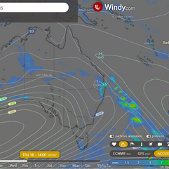
New Zealand's high weakens, causing ridge and winds over eastern Queensland. Trough brings unsettled weather to far southwestern Queensland, then moves eastward across the state, leading to increased rainfall and instability.
State
A high near New Zealand keeps onshore winds and a ridge over eastern Queensland, but will weaken gradually. A trough in far southwestern Queensland brings unsettled weather by pulling warm air from the interior. The trough will move eastward across western, southern, and central Queensland throughout the week. A mid-week upper trough in southern Queensland will cause more rain and instability.
4-day
Monday: Scattered showers and storms in western QLD and the Gulf Country. Partly cloudy with isolated showers in the Wet Tropics. Mostly clear elsewhere. Light to moderate winds shifting from northeast to southeast to southwest in the Channel Country.
Tuesday: Some showers and storms in SW Queensland and inland SE Queensland, little rainfall. Partially cloudy in Far North, mostly sunny elsewhere. Warmer than average temps south of Hughenden, very warm in far south. High risk of fires inland.
Wednesday: Cloudy with scattered showers and thunderstorms in southern and southeast Queensland, mainly inland. Mostly sunny elsewhere. Above average temperatures in central and southern Queensland, well above average in the interior.
Thursday: Thursday: Some rain and thunderstorms in parts of Queensland, especially in the south and central regions. In southeast Queensland, the rain will be more scattered. The rest of the state will have mostly sunny weather. Temperatures will be higher than usual, especially in the central interior.
Townsville
Min 21°C, Max 31°C, 🌤️. Chance of rain: 5%. Light winds becoming east to northeasterly 20-30 km/h in the morning, then light in the evening.
Herbert and Lower Burdekin
Min 18°C, Max 31°C, 🌤️. Chance of rain: 5%. Easterly winds 15 to 25 km/h turning northeasterly 20 to 30 km/h in the late afternoon.
North Tropical Coast and Tablelands
Min 17°C, Max 31°C, 🌥️. Chance of rain: 0%. East to southeasterly winds 15 to 25 km/h.
Cairns
Min 21°C, Max 31°C, 🌤️. Rain chance: 5%. Light winds, becoming E to SE 15-25 km/h in the morning, then light in the evening.
Mackay
Min 19°C, Max 29°C, 🌤️. Rain chance: 5%. Light winds, becoming E 15-25 km/h in the morning, then light in the evening.
Northern Goldfields
Min 20°C, Max 37°C, ☀️. Rain chance: 0%. Northern Goldfields and Upper Flinders area - Sunny. Winds east to northeasterly 20 to 30 km/h.
Mt Isa
Min 22°C, Max 38°C, ☀️. Rain chance: 0%. 🌬️ Light winds becoming easterly 15 to 20 km/h in the early afternoon, then light in the evening.
Click here to support to Wally's Weather
National maps by Weatherzone (weatherzone.com.au)
State maps by Windy (Windy.com)
Weather forecast supplemented by Bureau of Meteorology (bom.gov.au)
Rainfall daily totals (https://meteologix.com/ )
Wally's Weather provides professionally researched data and information. Andrew aka 'Wally' has over 20 years of experience in meteorology research and data analysis. In 2023 finished top 4 for the AMOS national weather forecasting competition. The content here is provided as educational information aimed at providing the community and businesses with the tools required to determine local-based forecasts. IMPORTANT: The forecasts and information posted should never be used on their own to make business decisions as local influences.


Comments