Morning Weather - November 14 - Wally's Weather Australia
- Nov 14, 2023
- 4 min read
This weather update is brought to you by Genesis Electrical NQ

Genesis Electrical NQ
We can Solve all of your Electrical, Air Conditioning and Solar needs!
Green Energy Initiative
Phone: 1300 443 637
Email: info@genesislec.com
Prize money for the best guess on each cyclone in 2023/24. Select the cyclone name, start date, end date, category and region it starts. Fill out the form here, you need to be a member http://wallysweather.com.au/cyclone-season
Sign up as a member free to enter
The rules are set out on the page.
Storms special report
Troughs will bring showers and storms to WA, western SA, northern NSW, south and west QLD, and the NT. Troughs will maintain heat over the interior and draw heat into the east.
Another trough will lead to some showers over eastern TAS, eastern VIC, and southeast NSW.
WEATHER WARNINGS
Severe Thunderstorm Warning (Damaging Winds & Large Hailstones) for Goldfields, South East Coastal, Great Southern & South Coastal districts
Strong Wind Warning for Monday for Leeuwin Coast. Cancellation for Monday for Esperance Coast
Road Weather Alert for slippery Roads for Monday for Adelaide
Strong Wind Warning Banks Strait & Franklin Sound, East of Flinders Is & CN, South East & South West coasts. Cancelled Central West Coast
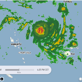
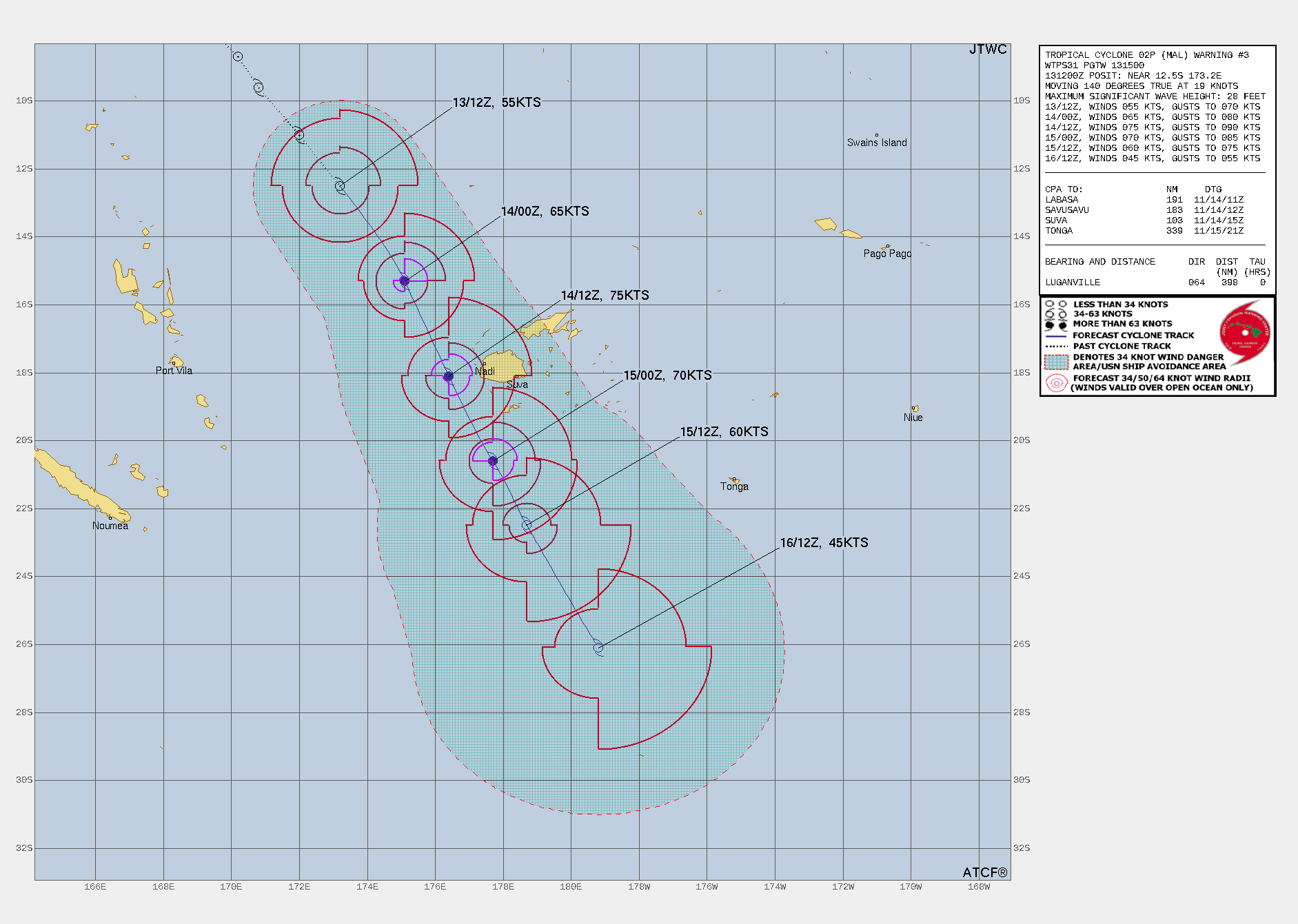
Tropical cyclone Mal special report
Positioned about 451 nautical miles northwest of Suva, Fiji, has moved southeastward at a speed of 19 knots in the last six hours. As of 131200Z, the minimum central pressure is 982 millibars, and the maximum significant wave height is recorded at 28 feet. The long range picked up this early pulse and thus Cyclone Mal, and if that plus Lola being forecast 2 months out doesn't convince you to check the long range out then I challenge you to enter the cyclone forecast competition.
ECWMF Thunderstorms | Cyclone Mal Radar | JTWC Forecast Path


National
High near New Zealand maintains ridge and settled conditions over eastern Queensland, weakening soon. Trough extends over southwest Qld, drags warm air, causing unsettled conditions and slowly moves east across Qld. Upper trough crosses southern Qld mid-week, increasing rainfall and instability. Southeasterly change brings cooler conditions in SE Qld from Friday.


State
A high in New Zealand keeps settled conditions over eastern Queensland. A trough brings warm air and unsettled conditions in southwestern Queensland. The trough slowly moves eastward across different parts of Queensland during the week. An upper trough increases rainfall and instability in southern Queensland mid-week. A southeasterly change brings cooler conditions to southeastern Queensland on Friday.


4-day
Monday: Isolated showers and thunderstorms in western Gulf Country and southern Queensland. Partly cloudy in Far North, mostly
Wednesday: Cloudy with showers and thunderstorms in southern interior and inland southeast Queensland. Severe thunderstorms possible in certain areas. Mostly sunny elsewhere. Above-average temperatures in the interior and eastern districts with severe heatwave conditions in the Channel Country.
Thursday: Isolated showers and thunderstorms in southern and central Queensland, becoming scattered in southeast Queensland. Severe thunderstorms possible in certain areas. Mostly sunny elsewhere. Above average temperatures, with severe heatwave conditions in the northern interior.
Friday: Eastern districts south of Townsville may experience scattered showers and thunderstorms, while central and southeast Queensland may have more scattered showers. There is a chance of isolated thunderstorms in the northern interior. Otherwise, it


Townsville
Min 20°C, Max 31°C, Mostly sunny. Chance of any rain: 0%. Mostly sunny. Light winds becoming northeasterly 15 to 25 km/h in the middle of the day then becoming light in the evening.
Herbert and Lower Burdekin
Min 17°C, Max 31°C, Mostly sunny. Chance of any rain: 0%. Light winds becoming east to northeasterly 15 to 25 km/h in the morning then becoming light in the evening.
North Tropical Coast and Tablelands
Min 16°C, Max 31°C, Mostly sunny. Chance of any rain: 0%. Winds east to southeasterly 15 to 20 km/h becoming light early in the morning then becoming easterly 15 to 25 km/h in the morning.
Cairns
Min 20°C, Max 31°C, Partly cloudy. Chance of any rain: 5%. Light winds becoming easterly 15 to 20 km/h in the morning then becoming light in the evening.
Mackay
Min 17°C, Max 29°C, Mostly sunny. Chance of any rain: 0%. Light winds becoming northeasterly 15 to 20 km/h in the middle of the day then becoming light in the late afternoon.
Northern Goldfields
Min 18°C, Max 37°C, Sunny. Chance of any rain: 0%. Winds east to northeasterly 20 to 30 km/h.
Mt Isa
Min 21°C, Max 39°C, Sunny. Chance of any rain: 0%. Sunny. Light winds becoming northeasterly 15 to 20 km/h in the morning then becoming light in the evening.
Click here to support to Wally's Weather
National maps by Weatherzone (weatherzone.com.au)
State maps by Windy (Windy.com)
Weather forecast supplemented by Bureau of Meteorology (bom.gov.au)
Rainfall daily totals (https://meteologix.com/ )
AccuWeather (https://www.accuweather.com/)
Wally's Weather provides professionally researched data and information. Andrew aka 'Wally' has over 20 years of experience in meteorology research and data analysis. In 2023 finished top 4 for the AMOS national weather forecasting competition. The content here is provided as educational information aimed at providing the community and businesses with the tools required to determine local-based forecasts. IMPORTANT: The forecasts and information posted should never be used on their own to make business decisions as local influences.


Comments