Morning Weather - November 17 - Wally's Weather Australia
- Nov 17, 2023
- 4 min read
This weather update is brought to you by Genesis Electrical NQ

Genesis Electrical NQ
We can Solve all of your Electrical, Air Conditioning and Solar needs!
Green Energy Initiative
Phone: 1300 443 637
Email: info@genesislec.com
Prize money for the best guess on each cyclone in 2023/24. Select the cyclone name, start date, end date, category and region it starts. Fill out the form here, you need to be a member http://wallysweather.com.au/cyclone-season
Sign up as a member free to enter
The rules are set out on the page.
Storms special report
For the NQ, the 22nd to 27th look good for showers and possibly rain. Troughs will cause showers and storms over NT, SA, and eastern WA, extending into QLD and trapping heat to their north.Cooler southerly winds will bring showers to northeastern NSW and southeast QLD. Another cold front will brush TAS, pushing cool winds over VIC.
WEATHER WARNINGS:
Strong Wind Warning for South East and South West coasts.
Storm Force Wind Warning for Southern Area.
Strong Wind Warning for Byron, Coffs, Macquarie, Hunter, Sydney, and Illawarra coasts. Strong Wind Warning for Thursday for Geraldton and Leeuwin coasts. Cancellation for Thursday for Gascoyne Coast.
Strong Wind Warning for Sunshine Coast Waters. Cancellation for Gold Coast Waters.
Strong Wind Warning for Far West and Upper West coasts. Cancellation for Spencer Gulf, Gulf St Vincent, and Lower West Coast.
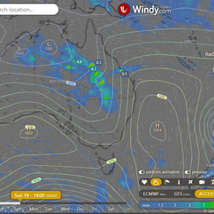
ECWMF 24 Hour Accumulated Animation

National
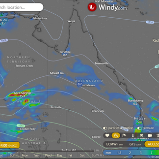
Weak ridge over north QLD, trough across interior, brings warm and unsettled south; trough moves east, high moving south creates cooler wind change; ridge extends along east coast, pushing trough west; onshore winds increase moisture, more showers and storms.


State
Weak ridge over northern Queensland, trough across the interior, causing warm and unsettled conditions in the south. Trough moving slowly east and north, reaching southern Queensland coast on Friday. High moving into the Great Australian Bight, bringing
cooler wind change along southern Queensland coast on Friday. Ridge extending further along east coast over the weekend, pushing trough back over western Queensland. Onshore winds increasing moisture across state, leading to more widespread shower and thunderstorm activity next week.


4-day
Saturday: Cloudy with showers and thunderstorms in Capricornia and Central Highlands, could be severe. Isolated showers and thunderstorms in inland districts. Mostly sunny in the Far North, partly cloudy elsewhere. Interior temperatures above average, eastern southeastern Queensland temperatures below average.
Sunday: In the Far North, it will be mostly sunny, while the southeast will be partly cloudy. The interior of the state will see increasing cloud cover with scattered showers, isolated thunderstorms, and patchy rain areas. Thunderstorms may become severe in the Maranoa and Warrego regions. Maximum temperatures will be below average in a band that stretches from the North West across most of the state.
Monday: Inland: Cloudy with showers and thunderstorms, becoming widespread rain in parts of southeastern and central Queensland. Thunderstorms inland.
Tuesday: Cloudy with showers and thunderstorms in central, southeastern, and interior Queensland. Rain and heavy falls with thunderstorms possible. Thunderstorms inland. Partly cloudy with isolated showers and thunderstorms in western Queensland. Showers becoming scattered in Far North Queensland. Below average maximum temperatures in most of the state.


Townsville
Min 23°C, Max 31°C, Mostly sunny. Rain chance: 0%. Light winds becoming N 15-25 km/h in the morning, then light in the evening.
Herbert and Lower Burdekin
Min 20°C, Max 32°C, Sunny. Rain chance: 0%. Slight chance of a thunderstorm in the south in the late afternoon and evening. Winds N 15-20 km/h becoming light before dawn, then becoming N to NE 15-25 km/h in the morning.
North Tropical Coast and Tablelands
Min 16°C, Max 35°C, Sunny. Rain chance: 0%. Light winds becoming E to NE 15-20 km/h in the middle of the day, then becoming light in the late evening.
Cairns
Min 19°C, Max 32°C, Sunny. Rain chance: 0%. Light winds becoming northeasterly 15 to 20 km/h in the early afternoon, then becoming light in the late afternoon.
Mackay
Min 20°C, Max 32°C, Mostly sunny. Chance of any rain: 5%. Winds northwesterly 20 to 25 km/h turning northerly 25 to 35 km/h in the morning.
Northern Goldfields
Min 22°C, Max 39°C, Sunny. Chance of any rain: 5%. Slight chance of a shower about the Gregory Ranges in the afternoon and evening. Near zero chance of rain elsewhere. The chance of a thunderstorm in the afternoon and evening. Winds north to northwesterly 15 to 25 km/h tending northwest to southwesterly in the middle of the day then tending northwest to northeasterly 15 to 20 km/h in the evening.
Mt Isa
Min 25°C, Max 41°C, Mostly sunny. Chance of any rain: 5%. Light winds.
Click here to support to Wally's Weather
National maps by Weatherzone (weatherzone.com.au)
State maps by Windy (Windy.com)
Weather forecast supplemented by Bureau of Meteorology (bom.gov.au)
Rainfall daily totals (https://meteologix.com/ )
AccuWeather (https://www.accuweather.com/)
Nine Weather (https://www.9news.com.au/weather)
Wally's Weather provides professionally researched data and information. Andrew aka 'Wally' has over 20 years of experience in meteorology research and data analysis. In 2023 finished top 4 for the AMOS national weather forecasting competition. The content here is provided as educational information aimed at providing the community and businesses with the tools required to determine local-based forecasts. IMPORTANT: The forecasts and information posted should never be used on their own to make business decisions as local influences.


Comments