Morning Weather - November 22 - Wally's Weather Australia
- Nov 22, 2023
- 5 min read
This weather update is brought to you by Genesis Electrical NQ

Genesis Electrical NQ
We can Solve all of your Electrical, Air Conditioning and Solar needs!
Green Energy Initiative
Phone: 1300 443 637
Email: info@genesislec.com
To locate the Big Shout posts,
1. Open your Web browser to Wally's Weather website
2. Click Weather at the top
3. Scroll down a little and click Big Shout
And there are all the Big Shout posts including the long range and the recent November rain blog.
To support us with a Big Shout, select the community page.
Storms special report
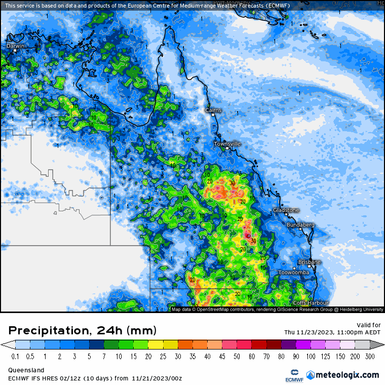
A trough over the eastern inland will sustain rain and storms in the north and over southern Queensland, with showers easing for southern New South Wales. Troughs extending over the north and west will trigger showers and storms across the tropics and inland Northern Territory, while driving heat over southwest Western Australia. As you can see by the storm image, QLD is pretty much a pizza of activity. However, rainfall appears to be maxing in some areas around 30 to 50mm over the 24 hours. The trough just reaching the dividing range but not moving past that in the next 24 hours. Thus NQ will only see onshore showers, and heavier for the FNQ.
WEATHER WARNINGS
Severe Thunderstorm Warning (Heavy Rain) for Central Highlands & Coalfields, Central West, Maranoa & Warrego, and Darling Downs & Granite Belt.
Severe Weather Warning (Damaging Winds) for parts of Lower West and South West districts.
Strong Wind Warning for Tuesday for Bunbury Geographe, Leeuwin, Albany & Esperance coasts.
Downy Mildew Advice for Wednesday for Mid North, Mount Lofty Ranges, Riverland, Murraylands, Upper South East, and Lower South East.
Strong Wind Warning for Spencer Gulf, St Vincent, Investigator Strait & South Central & Upper South East Coasts.
Gale Warning For Southeastern And Southern Areas.
Fire Weather Warning for Inland Central West, Lower West Inland, Brockman, and Mortlock.
Final Gale Warning For Southern Area.
ECMWF National Storm Midday | ECMWF QLD Accumulated Rain 3 Days | ECMWF QLD 8 x 24 hour Rainfall


National
Tasman Sea's high pressure brings humid air to western Queensland. This pattern persists, keeping moisture high. Southern Australia will experience unsettled weather due to eastward-moving upper troughs. Unsettled weather may reach eastern districts next week.


State
A high pressure system is drawing humid air into a trough over western Queensland, which will continue for the next week. Meanwhile, upper troughs will cause unsettled weather
in southern Australia before potentially moving to eastern districts next week.


4-day
Wednesday: Today's weather: Isolated showers and thunderstorms statewide. Scattered showers in central and northern areas and southeast. Possible severe thunderstorms inland. Light to moderate northerly winds, becoming easterly in the north. Variable winds in the far west.
Thursday: Thursday: Few showers and thunderstorms in the interior, isolated in far western Queensland. Showers in eastern districts. Some widespread shower and thunderstorm activity in the interior. Possible severe thunderstorms in the southern interior. Interior temperatures below average.
Friday: Friday: Isolated showers in the east and Darling Downs, scattered showers along North Tropical Coat and Mackay Coast. Showers and thunderstorms in the interior and Gulf Country, isolated in far Southwest. Severe thunderstorm possible in the south interior. Below average temperatures, especially in central west and northwest.
Saturday: Isolated showers in the east and Darling Downs, scattered in North and Far North Queensland. Scattered showers and thunderstorms in the interior and Gulf Country, isolated in the far southwest. Possible severe thunderstorm in the interior, uncertainty on focus areas. Cooler temperatures in the northwest and central/southern interior.


Townsville
Min 24°C Max 32°C Partly cloudy. Chance of any rain: 20%. Slight chance of a shower. Light winds becoming northeasterly 15 to 25 km/h in the morning, then becoming light in the evening.
Herbert and Lower Burdekin
Min 22°C Max 31°C Partly cloudy. Chance of any rain: 20%. Medium chance of showers in the north, slight chance elsewhere. The chance of a thunderstorm inland from late morning. Light winds becoming northeasterly 15 to 25 km/h in the morning.
North Tropical Coast and Tablelands
Min 21°C Max 31°C Partly cloudy. Possible rainfall: 0 to 2 mm. Chance of any rain: 30%. Medium chance of showers, most likely in the late morning and afternoon. The chance of a thunderstorm inland from late morning. Winds easterly 20 to 30 km/h.
Cairns
Min 24°C Max 31°C Morning shower or two. Possible rainfall: 0 to 3 mm. Chance of any rain: 60%. Partly cloudy. Medium chance of showers in the morning. Light winds becoming easterly 20 to 25 km/h in the morning then tending southeasterly 15 to 25 km/h in the evening.
Mackay
Min 21°C Max 30°C Partly cloudy. Possible rainfall: 0 to 1 mm. Chance of any rain: 30%. Slight chance of a shower. Light winds becoming easterly 15 to 20 km/h in the middle of the day then becoming light in the late evening.
Rockhampton
Min 22°C Max 30°C Possible shower. Possible rainfall: 0 to 2 mm. Chance of any rain: 40%. Partly cloudy. Medium chance of showers, most likely in the morning and afternoon. The chance of a thunderstorm in the morning and afternoon. Light winds becoming easterly 15 to 20 km/h in the early afternoon then becoming light in the evening.
Northern Goldfields
Min 24°C Max 36°C Showers. Possible storm. Possible rainfall: 5 to 20 mm. Chance of any rain: 90%. Partly cloudy. High chance of showers, most likely in the afternoon and evening. The chance of a thunderstorm. Winds northeasterly 15 to 20 km/h becoming light early in the morning then becoming east to northeasterly 15 to 20 km/h in the morning.
Longreach
Min 22°C Max 35°C Shower or two. Possible storm. Possible rainfall: 0 to 15 mm. Chance of any rain: 70%. Partly cloudy. High chance of showers, most likely from the late morning. The chance of a thunderstorm. Winds northeasterly 15 to 25 km/h tending easterly 15 to 20 km/h in the evening then becoming light in the late evening.
Mt Isa
Min 22°C Max 38°C Partly cloudy. Chance of any rain: 20%. Mostly sunny morning. Slight chance of a shower in the afternoon and evening. The chance of a thunderstorm in the afternoon and evening. Light winds.
Click here to support to Wally's Weather
National maps by Weatherzone (weatherzone.com.au)
State maps by Windy (Windy.com)
Weather forecast supplemented by Bureau of Meteorology (bom.gov.au)
Rainfall daily totals (https://meteologix.com/ )
AccuWeather (https://www.accuweather.com/)
Nine Weather (https://www.9news.com.au/weather)
Wally's Weather provides professionally researched data and information. Andrew aka 'Wally' has over 20 years of experience in meteorology research and data analysis. In 2023 finished top 4 for the AMOS national weather forecasting competition. The content here is provided as educational information aimed at providing the community and businesses with the tools required to determine local-based forecasts. IMPORTANT: The forecasts and information posted should never be used on their own to make business decisions as local influences.


Comments