Morning Weather - November 25 - Wally's Weather Australia
- Nov 25, 2023
- 6 min read
This weather update is brought to you by Genesis Electrical NQ

Genesis Electrical NQ
We can Solve all of your Electrical, Air Conditioning and Solar needs!
Green Energy Initiative
Phone: 1300 443 637
Email: info@genesislec.com
Storms special report
Broad troughs over the north, east, and interior deepening. Triggering rain, showers, and storms from northern WA to eastern NSW, Vic, and Tas. Persistent west coast trough maintaining intense heat over western WA. The High out over NZ is stalling the movement of the trough over QLD. That will add to the tally of rain in the West slightly, but delay the rain a day or so for the QLD coast.
WEATHER WARNINGS:
Strong Wind Warning for East Gippsland Coast
Strong Wind Warning for Far North West, South West, and Central West coasts
Downy Mildew Advice for Mount Lofty Ranges, Riverland, Murraylands, Upper South East, and Lower South East. (Cancellation for Mid North)
Strong Wind Warning for Illawarra, Batemans, and Eden coasts
Strong Wind Warning for Friday for Leeuwin and Albany coasts. (Cancellation for Esperance Coast on Friday)
Strong Wind Warning for Saturday for Lower South East Coast
Heatwave Warning (Repeated)
Minor Flood Warning for The Paroo River (Qld)
Major Flood Warning for The Wallam And Mungallala Creeks
Minor Flood Warning for The Paroo River (Nsw)
Moderate Flood Warning for The Moonie River
Initial Moderate Flood Warning For The Wallam Creek
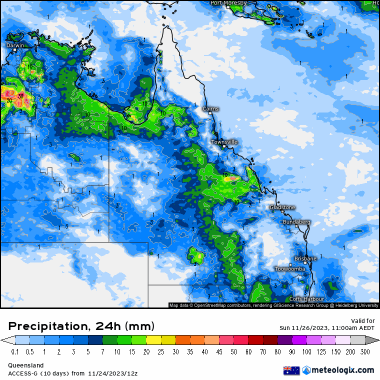
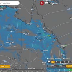
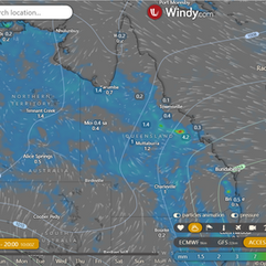
ECMWF Storm 4pm | ECMWF Accumulated Rain 3 Days | ACCESS QLD 8 x 24 hour Rainfall


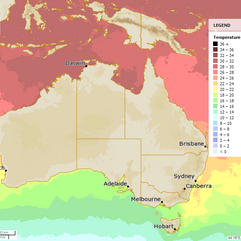
National
Humid air from Tasman Sea elevates pressure, bringing moisture and showers to Queensland. Eastern districts may experience showers next week.


State
A stationary high-pressure system is bringing humid air into a wide trough in western Queensland, causing above-average moisture levels. In addition, a series of upper troughs
will bring increased shower and thunderstorm activity to the interior and northwest of the state. This focus may shift to eastern districts next week.


4-day
Sunday: Sunday: Scattered showers and thunderstorms in inland QLD, with widespread at times in NW and Gulf Country. Isolated showers on the east coast, chance of thunderstorms in SE QLD, scattered north of St Lawrence. Severe thunderstorm possible in southern and SE interior near NSW border. Max temperatures below average in interior and NW QLD, slightly above average in far southwest and northern Peninsula, near/below average elsewhere.
Monday: Scattered showers and thunderstorms likely in most parts of the state. Heavy rain possible in Gulf Country, northwest, northern interior, and central districts. Isolated showers and thunderstorms expected in southwest and northern Peninsula. Temperatures will be below average in northwestern Queensland and above average in southeastern Queensland, with near-average temperatures elsewhere.
Tuesday: Rain and thunderstorms expected over most of southern Queensland, with potential for severe storms in central and southern districts. Isolated showers in western and northern areas. Temperature below average in northwest and interior, slightly above average in far southwest and northern areas, and near average elsewhere.
Wednesday: Scattered showers and thunderstorms in east and north districts, becoming widespread in southeast Queensland on Wednesday. Showers and thunderstorms isolated in the west on Wednesday and interior on Thursday, potentially increasing over the weekend with the next trough. Severe thunderstorms possible in central and southeast districts on Wednesday, with uncertain focus areas. Maximum temperatures near or slightly below average in the interior and west, and above average in the east.


North Tropical Coast and Tablelands:
Expect partly cloudy conditions with a moderate chance of showers, mainly in the late morning and afternoon. There's also a possibility of thunderstorms. Winds will start from the northeast to southeasterly at 15 to 20 km/h, becoming light before dawn and then shifting to east to northeasterly at 15 to 20 km/h in the morning. Overnight temperatures will drop to a range of 18 to 23 degrees Celsius, with daytime temperatures reaching 28 to 33 degrees Celsius.
Herbert and Lower Burdekin (Townsville):
Anticipate cloudy weather with a high chance of showers in the north and a medium chance elsewhere. Thunderstorms are also possible. Winds will be light, becoming northeasterly at 15 to 20 km/h in the middle of the day and then light in the evening. Overnight temperatures will fall to the low 20s, and daytime temperatures will reach around 30 degrees Celsius.
Central Coast and Whitsundays:
Expect partly cloudy skies with a moderate chance of showers, especially in the late morning and afternoon. The likelihood of a thunderstorm exists. Light winds will become northeasterly at 15 to 20 km/h in the middle of the day and then light in the late evening. Overnight temperatures will range from 19 to 22, with daytime temperatures reaching 27 to 32 degrees Celsius.
Peninsula:
Conditions will be partly cloudy with a slight chance of a shower south of Coen, and almost no chance elsewhere. Thunderstorms are possible. Light winds will shift from east to northeasterly at 15 to 20 km/h in the morning and then become light in the late evening. Overnight temperatures will drop to the low to mid 20s, with daytime temperatures ranging from 33 to 38 degrees Celsius.
Gulf Country:
Expect partly cloudy weather with a moderate chance of showers and the possibility of a thunderstorm. Light winds will become north to northwesterly at 15 to 20 km/h in the early afternoon and then become light in the evening. Overnight temperatures will fall to the low to mid 20s, with daytime temperatures in the low to mid 30s.
Northern Goldfields and Upper Flinders:
Conditions will be partly cloudy with a moderate chance of showers, especially in the afternoon and evening. Thunderstorms are possible. Winds will shift from north to northeasterly at 15 to 20 km/h, becoming light in the middle of the day, and then becoming northeast to southeasterly at 15 to 20 km/h in the evening. Overnight temperatures will drop to the low 20s, with daytime temperatures ranging from 29 to 35 degrees Celsius.
Capricornia:
Expect partly cloudy conditions with a moderate chance of showers, mainly in the late morning and afternoon. The chance of a thunderstorm exists inland. Light winds will become northeasterly at 15 to 20 km/h in the early afternoon and then become light in the late evening. Overnight temperatures will fall to between 16 and 20, with daytime temperatures reaching around 30 degrees Celsius.
Central Highlands and Coalfields:
Conditions will be partly cloudy with a moderate chance of showers, particularly from the late morning. The chance of a thunderstorm exists. Light winds are expected. Overnight temperatures will fall to between 17 and 21, with daytime temperatures around 30 degrees Celsius.
Central West:
Expect partly cloudy conditions with a moderate chance of showers east of Longreach and a slight chance elsewhere. The chance of a thunderstorm exists. Winds will be northeasterly at 15 to 20 km/h, becoming light in the morning, and then becoming easterly at 15 to 20 km/h in the evening. Overnight temperatures will fall to between 18 and 21, with daytime temperatures ranging from 28 to 35 degrees Celsius.
North West:
Conditions will be partly cloudy with a high chance of showers in the northwest and a medium chance elsewhere. The chance of a thunderstorm exists. Winds will be north to northeasterly at 15 to 20 km/h, becoming light in the morning, and then becoming northwest to northeasterly at 15 to 20 km/h in the late afternoon. Overnight temperatures will fall to the low 20s, with daytime temperatures in the low to high 30s.
Channel Country:
Expect a sunny morning with a slight chance of a shower in the afternoon and evening. The chance of a thunderstorm exists in the afternoon and evening. Winds will be northeast to southeasterly at 15 to 20 km/h, shifting to north to northeasterly at 15 to 25 km/h in the morning, and then tending northeast to southeasterly in the early afternoon. Overnight temperatures will fall to the low 20s, with daytime temperatures ranging from mid to high 30s.
Maranoa and Warrego:
Conditions will be partly cloudy with a moderate chance of showers in the northeast and a slight chance elsewhere. The chance of a thunderstorm exists. Light winds will become northerly at 15 to 20 km/h early in the morning, and then become light in the morning. Overnight temperatures will fall to between 17 and 20, with daytime temperatures around 30 degrees Celsius.
Darling Downs and Granite Belt:
Expect partly cloudy conditions with a moderate chance of showers, particularly in the morning and afternoon. The chance of a thunderstorm exists. Light winds will become northerly at 15 to 20 km/h early in the morning, and then become light in the morning. Overnight temperatures will fall to between 15 and 18, with daytime temperatures around 30 degrees Celsius.
Wide Bay and Burnett:
Conditions will be partly cloudy with a slight chance of a shower, most likely from the late morning. The chance of a thunderstorm exists inland. Light winds are expected. Overnight temperatures will fall to between 15 and 18, with daytime temperatures reaching around 30 degrees Celsius.
Southeast Coast:
Expect partly cloudy conditions with a slight chance of a shower, most likely from the late morning. The chance of a thunderstorm exists inland. Light winds will become north to northeasterly at 15 to 20 km/h in the early afternoon, and then become light in the evening. Overnight temperatures will fall to between 16 and 19, with daytime temperatures around 30 degrees Celsius.
Click here to support to Wally's Weather
National maps by Weatherzone (weatherzone.com.au)
State maps by Windy (Windy.com)
Weather forecast supplemented by Bureau of Meteorology (bom.gov.au)
Rainfall daily totals (https://meteologix.com/ )
AccuWeather (https://www.accuweather.com/)
Nine Weather (https://www.9news.com.au/weather)
Wally's Weather provides professionally researched data and information. Andrew aka 'Wally' has over 20 years of experience in meteorology research and data analysis. In 2023 finished top 4 for the AMOS national weather forecasting competition. The content here is provided as educational information aimed at providing the community and businesses with the tools required to determine local-based forecasts. IMPORTANT: The forecasts and information posted should never be used on their own to make business decisions as local influences.


Comments