Morning Weather - November 28 - Wally's Weather Australia
- Nov 28, 2023
- 5 min read
This weather update is brought to you by Genesis Electrical NQ

Genesis Electrical NQ
We can Solve all of your Electrical, Air Conditioning and Solar needs!
Green Energy Initiative
Phone: 1300 443 637
Email: info@genesislec.com
Storms special report
Widespread rain and storms expected in QLD, NSW, VIC, and SA, with some areas experiencing intense conditions due to intensified and moisture-laden eastward troughs.
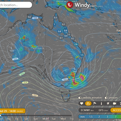
Wind strengthening anticipated in southern NSW, VIC, and SA due to a developing low.
Showers and storms triggered in southern WA by a trough.
Weather Warnings
Severe Thunderstorm Warning (Heavy Rain & Damaging Winds) issued for Adelaide, Mt Lofty R, Yorke Pen, Mid N & L Eyre, E Eyre & Murraylands districts.
Strong Wind Warning for Leeuwin, Albany, Esperance, and Eucla coasts on Monday.
Downy Mildew Advice for Mid North, Mount Lofty Ranges, Riverland, Murraylands, and Upper South East.
Sheep Graziers Warnings issued for various regions in Eastern Eyre Peninsula, Lower Eyre Peninsula, Mid North, Yorke Peninsula, Mount Lofty Ranges, Kangaroo Island, Illawarra, Southern Tablelands, Central West Slopes and Plains, South West Slopes, Riverina, and Snowy Mountains.
Strong Wind Warnings for various coastal regions, including Far North West Coast and Tuesday warnings for Sydney, Illawarra, and Eden coasts, as well as Port Phillip, Gippsland Lakes & West, Central, Central Gippsland, and East Gippsland coasts.
Initial Flood Watch for parts of the New South Wales South Coast Rivers, Inland Central West Rivers, and South West Rivers.
Minor and Moderate Flood Warnings for Paroo River (Qld and Nsw), Wallam Creek, Mungallala Creek, Moonie River, Barcoo River, and Wallam Creek.
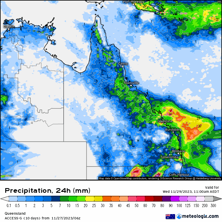
ECMWF Storm 4pm | ECMWF Accumulated Rain 3 Days | ACCESS QLD 8 x 24 hour Rainfall


National
Broad trough over western Queensland and humid airmass over most of state persists. Upper troughs move eastwards, heightening shower and thunderstorm activity. Low pressure system bringing trough to southwestern Queensland, potentially affecting southeast Queensland. Trough may linger over south and west Queensland into next weekend.


State
A trough will cover western Queensland with humid air, while upper troughs will move east across southern Australia, increasing showers and storms in the north and central interior. A low pressure system will push a trough over southwestern Queensland, potentially reaching southeast Queensland later in the week, and remaining slow-moving over southern and western Queensland over the weekend.


4-day
Tuesday: Scattered showers and thunderstorms in most of the state south of Weipa to Cooktown, widespread with potential severe thunderstorms in the northwest, north interior, and central districts. Possible severe thunderstorms southeast of Roma and east of Warwick. Isolated showers and thunderstorms in the southwest and northern Peninsula. Light to moderate northwest to northeasterly winds.
Wednesday: Scattered showers and thunderstorms in eastern and northern districts, becoming widespread at times in southeastern Queensland. Possible severe thunderstorms in the southeast, south of Emerald to Rockhampton and east of Mitchell to Mungindi. Isolated showers in the eastern Peninsula. Mostly sunny in the far southwest. Above average maximum temperatures. Very warm, dry and gusty northwesterly winds with high fire danger in the Central West and southern interior. Locally severe heatwave conditions in Far North Queensland.
Thursday: Inland showers and thunderstorms in most of the state, with more showers along the east coast. Higher temperatures in the east and southeast, leading to high fire danger. Heatwave conditions in Far North Queensland.
Friday: Scattered showers and thunderstorms across state, widespread in central interior, isolated on east coast above St. Lawrence. Above average temps in east, well above average in southeast. High fire risk in far west.


North Tropical Coast and Tablelands:
Overnight temperatures: 18-23°C, daytime temperatures: 29-35°C, light winds becoming east to northeasterly 15-20 km/h, partly cloudy with a medium chance of showers in the south and a slight chance elsewhere, and a chance of thunderstorms.
Herbert and Lower Burdekin (Townsville):
Overnight temperatures: low to mid-20s°C, daytime temperatures: low to mid-30s°C, light winds becoming northerly 15-20 km/h, partly cloudy with a medium chance of showers, and a chance of thunderstorms.
Central Coast and Whitsundays:
Overnight temperatures: low 20s°C, daytime temperatures: 28 to 33°C, light winds becoming northerly 15-20 km/h, high chance of morning and afternoon showers, and a chance of thunderstorms under partly cloudy skies.
Peninsula:
Overnight temperatures: low to mid 20s°C, daytime temperatures: 34 to 39°C, light winds becoming northeast to southeasterly 15-20 km/h, slight chance of a shower, and a chance of thunderstorms under partly cloudy skies.
Gulf Country:
Overnight temperatures: low to mid 20s°C, daytime temperatures: low to high 30s°C, light winds becoming west to northwesterly 15-20 km/h, slight chance of a shower, and a chance of thunderstorms under partly cloudy skies.
Northern Goldfields and Upper Flinders:
Overnight temperatures: low 20s°C, daytime temperatures: 30 to 35°C, winds north to northwesterly 15-20 km/h, becoming west to northwesterly 15-25 km/h in the morning, then becoming light in the evening. Medium chance of showers, most likely in the morning and afternoon, with a chance of thunderstorms under partly cloudy skies.
Capricornia:
Overnight temperatures: between 18 and 21°C, daytime temperatures: mid to high 20s°C, winds becoming north to northeasterly 15-20 km/h in the morning, then becoming light in the late afternoon. Very high chance of rain, most likely in the morning and afternoon, with a chance of thunderstorms under cloudy skies.
Central Highlands and Coalfields:
Overnight temperatures: between 18 and 21°C, daytime temperatures: 25 to 32°C, winds becoming northwest to northeasterly 15-20 km/h in the morning, then becoming light in the middle of the day. Very high chance of rain, most likely in the morning and afternoon, with a chance of thunderstorms under partly cloudy skies.
Central West:
Overnight temperatures: around 20°C, daytime temperatures: 31 to 37°C. Mostly sunny with a medium chance of showers in the northeast and a slight chance elsewhere. The chance of a thunderstorm in the morning and afternoon, with light winds.
North West:
Overnight temperatures: low to mid 20s°C, daytime temperatures: mid to high 30s°C. Mostly sunny with a slight chance of a shower near the New South Wales border and near-zero chance elsewhere. The chance of a possibly severe thunderstorm in the east. Winds north to northeasterly 25 to 35 km/h, becoming north to northwesterly 25 to 40 km/h in the morning, then shifting to northwest to southwesterly in the middle of the day.
Channel Country:
Overnight temperatures: Low to mid 20s°C, daytime temperatures: Mid to high 30s°C. Mostly sunny with a slight chance of a shower near the New South Wales border and near zero chance elsewhere. The chance of a possibly severe thunderstorm in the east. Winds from the north to northeasterly at 25 to 35 km/h, tending to north to northwesterly at 25 to 40 km/h in the morning, then shifting to northwest to southwesterly in the middle of the day.
Maranoa and Warrego:
Overnight temperatures: 18 to 21°C, daytime temperatures: 28 to 36°C. Mostly sunny with a medium chance of showers in the east and a slight chance elsewhere. The chance of a possibly severe thunderstorm. Winds light, becoming north to northeasterly 20 to 30 km/h in the morning.
Darling Downs and Granite Belt:
Overnight temperatures: 18 to 21°C, daytime temperatures: 23 to 28°C. Cloudy with a high chance of rain, most likely in the morning and afternoon. The chance of a thunderstorm. Light winds becoming northeasterly at 15 to 25 km/h in the morning.
Wide Bay and Burnett:
Overnight temperatures: 17 to 20°C, daytime temperatures: low to mid 20s°C. Cloudy with a very high chance of rain, most likely in the morning and afternoon. The chance of a thunderstorm. Light winds.
Southeast Coast:
Overnight temperatures: around 19°C, daytime temperatures: low to mid 20s°C. Cloudy with a very high chance of rain, most likely in the morning and afternoon. The chance of a thunderstorm. Light winds becoming northeasterly 15 to 20 km/h in the late afternoon. Heavy falls possible in the early morning about the coast.
Click here to support to Wally's Weather
National maps by Weatherzone (weatherzone.com.au)
State maps by Windy (Windy.com)
Weather forecast supplemented by Bureau of Meteorology (bom.gov.au)
Rainfall daily totals (https://meteologix.com/ )
AccuWeather (https://www.accuweather.com/)
Nine Weather (https://www.9news.com.au/weather)
Wally's Weather provides professionally researched data and information. Andrew aka 'Wally' has over 20 years of experience in meteorology research and data analysis. In 2023 finished top 4 for the AMOS national weather forecasting competition. The content here is provided as educational information aimed at providing the community and businesses with the tools required to determine local-based forecasts. IMPORTANT: The forecasts and information posted should never be used on their own to make business decisions as local influences.


Comments