Morning Weather - November 8 - Wally's Weather Australia
- Nov 8, 2023
- 4 min read
This weather update is brought to you by Genesis Electrical NQ

Genesis Electrical NQ
We can Solve all of your Electrical, Air Conditioning and Solar needs!
Phone: 1300 443 637
Email: info@genesislec.com
Wanting to know how the rain works, specially in the NQ?
Have a look at Dam Filler the board game that educates without having to learn before playing.
Storms and tropical low special report
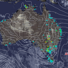
Storms again across multiple states, the NW WA, QLD, NSW and Victoria and even including Tasmania. To a small extent SA. The trough in QLD moves closer to the coast and mainly impacts the SEQ.
Meanwhile the tropical lows East of the Solomon Islands are switching strength, the low to the West is gaining in intensity and the low to the East is weakening.


National
Inland trough boosts rain activity, moving west later. East coast ridge stays. Southwest trough may move southeast next week.


State
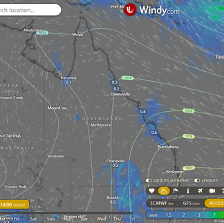
A slow-moving trough is causing more rain and thunderstorms in southern and central interior. It will move west from Wednesday, leading to more storms in western Queensland. A high over the Tasman Sea will keep a ridge along the east coast throughout the week and weekend. Another trough may move into southwest Queensland over the weekend, potentially reaching the southeast early next week.


4-day
Wednesday: There will be some showers and thunderstorms in the central and southern interior, with the possibility of severe storms in the west. Showers are expected in the eastern districts south of Cooktown, with a chance of thunderstorms inland. The weather will be partly cloudy in eastern Cape York Peninsula and mostly clear elsewhere. Winds will be light to moderate from the southeast to northeast.
Thursday: Isolated showers in eastern Queensland mainly between Cooktown and Townsville. Isolated showers and thunderstorms in western, central, and southern parts of Queensland and the Gulf Country southwest of Kowanyama to Surat and the Granite Belt. Showers becoming scattered at times in the North West. Partly cloudy elsewhere. Above-average temperatures in the southwest and below-average minimums in the central and southeastern districts. High to locally extreme fire danger in western Queensland.
Friday: Isolated showers in southeastern inland and near the east coast, mainly between Townsville and Cooktown. Isolated showers and thunderstorms in western, central, and southern interior Queensland and the Gulf Country southwest of Kowanyama to Goondiwindi and the Granite Belt. Showers becoming scattered at times in the North West. Mostly sunny elsewhere. Above-average temperatures in the southwest with below-average minimums in the east. High fire dangers in the southwest, central, and southern interior.
Saturday: Isolated showers in the southeast inland and near the east coast, mainly between Mackay and Cooktown. Isolated showers and thunderstorms in the North West and Gulf Country west of Croydon. Isolated showers and possible thunderstorms about the Granite Belt. Partly cloudy elsewhere. Above average temperatures in the southwest and southern interior, near or below average elsewhere. High fire dangers in the interior.


Townsville
Min 22°C, Max 30°C, Shower or two. Rainfall: 0-1 mm. Chance of rain: 60%. Medium chance of early morning showers. Light winds becoming E to NE 15-25 km/h in the morning.
Herbert and Lower Burdekin
Min 20°C, Max 30°C, Possible early shower. Rainfall: 0-1 mm. Chance of rain: 40%. Medium chance of coastal showers, slight chance elsewhere. Winds E 15-20 km/h, becoming light early in the morning, then becoming E to NE 15-25 km/h in the morning.
North Tropical Coast and Tablelands
Min 19°C, Max 31°C, Partly cloudy. Rainfall: 0-1 mm. Chance of rain: 30%. Slight chance of a south shower, near zero chance elsewhere. Winds E 15-25 km/h.
Cairns
Min 22°C, Max 30°C, Possible AM shower. Rainfall: 0-1 mm. Chance of rain: 40%. Medium chance of AM showers. Light winds becoming E 15-25 km/h in the morning, then SE in the late afternoon.
Mackay
Min 19°C, Max 27°C, Shower or two. Rainfall: 0-5 mm. Chance of rain: 50%. Medium chance of showers, mainly in the morning and afternoon. Winds E 15-20 km/h, becoming light before dawn, then E 15-25 km/h in the morning.
Northern Goldfields
Min 22°C, Max 36°C, Sunny. Chance of rain: 10%. Slight chance of a Gregory Ranges shower from late morning. Near zero chance elsewhere. Chance of a thunderstorm from late morning. Winds E to NE 20-30 km/h, becoming light in the middle of the day, then E to NE 15-25 km/h in the late afternoon.
Mt Isa
Min 20°C, Max 39°C, Partly cloudy. Chance of rain: 20%. Sunny morning. Slight afternoon and evening shower chance, with a chance of a thunderstorm. Light winds becoming N 15-20 km/h in the morning, then light in the middle of the day.
Click here to support to Wally's Weather
National maps by Weatherzone (weatherzone.com.au)
State maps by Windy (Windy.com)
Weather forecast supplemented by Bureau of Meteorology (bom.gov.au)
Rainfall daily totals (https://meteologix.com/ )
Wally's Weather provides professionally researched data and information. Andrew aka 'Wally' has over 20 years of experience in meteorology research and data analysis. In 2023 finished top 4 for the AMOS national weather forecasting competition. The content here is provided as educational information aimed at providing the community and businesses with the tools required to determine local-based forecasts. IMPORTANT: The forecasts and information posted should never be used on their own to make business decisions as local influences.


Comments