Morning Weather - October 16 - Wally's Weather Australia
- Oct 15, 2023
- 3 min read
This weather update is brought to you by Gecko Interior

Welcome to Gecko Interiors, a fun and colourful gift and homewares store based in tropical North Queensland, Australia. . Whether you're a local shopping from home, or dropped into my store while on a recent holiday to Townsville (with no room left to take everything back in your suitcase! ), let us take care of delivering to you.
National
Weak high pressure over eastern and far north QLD. Trough deepens, moves east across southern QLD. Cold front moves across southeastern states. High pressure follows trough. Southeasterly wind surge on east coast from Tuesday. Inland trough over western QLD.


State
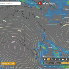
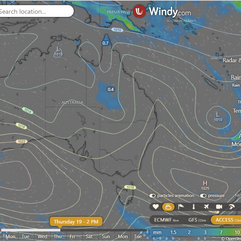
Weak high pressure extends over eastern and far north Queensland, with a trough through the interior. On Monday, the trough will deepen and move east across southern Queensland as a cold front clears offshore. A high moving across southern states will bring a ridge of high pressure over most of Queensland in the wake of the trough, with a southeasterly wind surge spreading north along the east coast from Tuesday. An inland trough will re-establish over western Queensland from Wednesday, then move eastward late in the week.


4-day
Monday: Partly clear with haze in Carnarvon Ranges and Peninsula. Winds: moderate northeasterly in east QLD, light to moderate in west QLD, and moderate southeast to northeast in far north.
Tuesday: Partly sunny. Cooler in the south. Warmer in central and north. High fire danger, reaching Extreme in Central West.
Wednesday: Isolated showers on Sunshine Coast, Gold Coast and east coast. Partly cloudy with chance of thunderstorm in Central West. Mostly sunny elsewhere. Temps slightly below average in east, slightly above average in west.
Thursday: Thursday: Light showers on coast, islands south of K'gari, Wet Tropics, Torres Strait. Partly cloudy, chance of thunderstorm inland. Mostly sunny elsewhere. Slightly below average temps in east, north; above average in southwest.


Townsville
Min 20 Max 30 Mostly sunny. Chance of any rain: 0%. Mostly sunny. Light winds becoming NE 15 to 25 km/h in the middle of the day, then becoming light in the evening.
Herbert and Lower Burdekin
Min 18 Max 31 Mostly sunny. Chance of any rain: 0%.Light winds becoming NE 15 to 25 km/h in the middle of the day, then becoming light in the late evening.
North Tropical Coast and Tablelands
Min 16 Max 33 Sunny. Chance of any rain: 0%. Winds E 15 to 25 km/h.
Cairns
Min 19 Max 32 Sunny. Chance of any rain: 0%. Light winds becoming E 15 to 20 km/h in the morning, then becoming light in the evening.
Mackay
Min 18 Max 30 Mostly sunny. Chance of any rain: 0%. Mostly sunny. Light winds becoming NE 15 to 20 km/h in the middle of the day, then becoming light in the evening.
Northern Goldfields
Min 22 Max 38 Partly cloudy. Chance of any rain: 0%. Winds NW to NE 15 to 20 km/h becoming light in the middle of the day, then becoming SE to SW 15 to 20 km/h in the late evening.
Mt Isa
Min 19 Max 36 Sunny. Chance of any rain: 0%. Winds S to SE 25 to 40 km/h becoming light in the early afternoon, then becoming S 15 to 20 km/h in the evening.
Click here to support to Wally's Weather
National maps by Weatherzone (weatherzone.com.au)
State maps by Windy (Windy.com)
Weather forecast supplemented by Bureau of Meteorology (bom.gov.au)
Rainfall daily totals (https://meteologix.com/ )
Wally's Weather provides professionally researched data and information. Andrew aka 'Wally' has over 20 years of experience in meteorology research and data analysis. In 2023 finished top 4 for the AMOS national weather forecasting competition. The content here is provided as educational information aimed at providing the community and businesses with the tools required to determine local-based forecasts. IMPORTANT: The forecasts and information posted should never be used on their own to make business decisions as local influences.


Comments