Morning Weather - September 2 - Wally's Weather Australia
- Sep 2, 2023
- 3 min read
This weather update is brought to you by Gecko Interior

Welcome to Gecko Interiors, a fun and colourful gift and homewares store based in tropical North Queensland, Australia. . Whether you're a local shopping from home, or dropped in to my store while on a recent holiday to Townsville (with no room left to take everything back in your suitcase! ), let us take care of delivering to you.
Check out the web store!!!! You're in for a treat! Enjoy browsing through our online store featuring all our best sellers and updated regularly with new stock. They also stock my game Dam Filler, grab your copy of Townsville's very own game now! Support local!
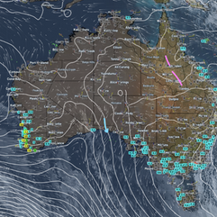
National
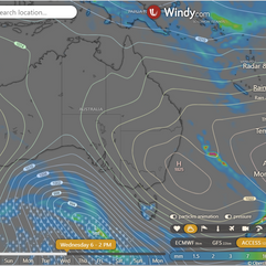
Weak trough extends over eastern Queensland and northern interior. Drifts west across central and northern Queensland on weekend. Tasmania high extends ridge over remainder of state. Reaches Tasman Sea later today and drifts southeast, with weak ridge persisting over state for few days. Tasman Sea low combines with high to direct southeasterly wind surge north along southeast coast until afternoon. Low drifts slowly east over next few days. Trough may cross southern Queensland Mon-Wed, followed by weak ridge. Second trough may cross southern and central Queensland Thu-Fri.


State
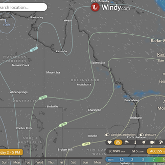
Eastern Queensland and the northern interior have a weak trough, which will move westward across central and northern Queensland on the weekend. Tasmania's high creates a ridge over the rest of the state, eventually moving southeast into the Tasman Sea, but leaving a weak ridge in place for a few days. A low in the Tasman Sea, along with the high, is pushing a southeasterly wind surge north along the southeast coast, lasting until this afternoon. The low will slowly move east in the next few days. From Monday to early Wednesday, a trough may pass through southern Queensland, followed by a weak ridge. On Thursday and Friday, a second trough is possible in southern and central Queensland.


4-day
Sunday: Isolated showers in east districts, mostly sunny elsewhere. Morning fog in east districts and inland southeast. Above average max temps in southwest and southern interior, near average elsewhere. Below average min temps, well below average in the west.
Monday: Forecast: Isolated to scattered showers in central & southern districts; chance of thunderstorms in SE Queensland. Mostly sunny elsewhere. Extreme fire danger inland in southern districts. High max temps in southwest & southern interior, average temps elsewhere. Above avg min temps south of Longreach, average temps in SE, below avg elsewhere.
Tuesday: Central and southern districts south of Rockhampton and east of Charleville may have isolated showers and a chance of a thunderstorm. There may be isolated showers in the Torres Strait. The rest of the areas will be mostly sunny, except for morning fog in the Gulf Country District. Extreme fire danger is expected in the Darling Downs and Granite Belt District. Maximum temperatures will be above average south of Hughenden and near average elsewhere. Minimum temperatures will be above average south of Longreach, near average in the southeast, and below average elsewhere.
Wednesday: Scattered showers in central and southern areas south of Rockhampton and east of Charleville, with a possible thunderstorm on Thursday. Isolated showers along the east coast north of Ingham and the Torres Strait. Mostly sunny elsewhere. Higher temperatures south of Hughenden, normal elsewhere. Typically warmer minimum temperatures south of Longreach, normal elsewhere.


Townsville
Max 28°C. Mostly sunny. 0% rain chance. Light winds, becoming N 15-20 km/h midday, then NE early PM.
Herbert and Lower Burdekin
Max 29°C. Mostly sunny. 0% rain chance. AM fog possible. NE winds 20-30 km/h, becoming light late eve.
North Tropical Coast and Tablelands
Max 28°C. Sunny. 0% rain chance. AM fog possible. Winds E/NE 20-30 km/h.
Cairns
Max 29°C. Sunny. 0% rain chance. Light winds, becoming E 15-20 km/h midday, then light in the evening.
Mackay
Max 27°C. Sunny. 10% rain chance. Light winds, becoming NE 15-20 km/h midday, then light in the evening.
Northern Goldfields
Max 34°C. Sunny. 0% rain chance. Winds N/NE 15-25 km/h.
Mt Isa
Max 30°C. Sunny. 0% rain chance. Light winds.
Click here to support to Wally's Weather
National maps by Weatherzone (weatherzone.com.au)
State maps by Windy (Windy.com)
Weather forecast supplemented by Bureau of Meteorology (bom.gov.au)
Rainfall daily totals (https://meteologix.com/ )
Wally's Weather provides professionally researched data and information. Andrew aka 'Wally' has over 20 years of experience in meteorology research and data analysis. The content here is provided as educational information aimed at providing the community and businesses with the tools required to determine local-based forecasts. IMPORTANT: The forecasts and information posted should never be used on their own to make business decisions as local influences.


Comments