Morning Weather - September 20 - Wally's Weather Australia
- Sep 20, 2023
- 3 min read
This weather update is brought to you by Gecko Interior

Welcome to Gecko Interiors, a fun and colourful gift and homewares store based in tropical North Queensland, Australia. . Whether you're a local shopping from home, or dropped into my store while on a recent holiday to Townsville (with no room left to take everything back in your suitcase! ), let us take care of delivering to you.
Dam Filler is an educational game ideal for homeschooling. This is a locally produced board game, based around Australian weather and teaches about the Dry Tropics including STEM concepts of Wind Speed, Direction, Relative Humidity and Pressure Systems. You don't need to know anything about that to play, you just play and learn as you go. The infographic left shows the steps each player takes during their turn. Watch the video on how to play.
National
Note the heating up of the Indian Ocean just West of Darwin, already warm enough for cyclone activity.
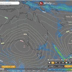
Slow-moving high over Tasman Sea extends ridge over Queensland, weakening as it moves east. Trough moves across interior on Wednesday, clearing offshore of Southeast Coast on Thursday. Northwesterly winds drag warm air across interior and southeast. Cooler wind change arrives late Thursday, spreading across southeast on Friday. High builds ridge across Queensland through end of week and weekend.


State
Ridge weakens as high moves east, trough brings warmer air, cool change follows. High builds pressure across Queensland.


4-day
Thursday: Dry, sunny weather with hot conditions in the southeast. Fresh, gusty southerly winds in the southwest. Moderate northeast to northwesterly winds in central and southeast Queensland before a southwesterly wind change moves into southeast Queensland. A fresh, cooler southeasterly wind change expected in the far southeast in the evening. Morning fog possible in eastern districts. Maximum temperatures well above average for most areas except the Peninsula and Channel Country. Minimum temperatures above average in the south, near average elsewhere. High fire danger in the southeast and western Queensland, with extreme danger in the Channel Country.
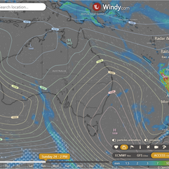
Friday: Most areas will be dry, sunny, and warm, except for some cloudiness and cooler temperatures in the southeast. There may be isolated showers along the coastal fringe. Maximum temperatures will be below average in the southeast but above average elsewhere. Minimum temperatures will be above average in the central interior and southeast, and near average elsewhere. There will be a high fire danger in western Queensland, reaching an extreme level in the Channel Country.
Saturday: The interior will be dry and mostly sunny. The east will be partly cloudy with isolated showers along the coast, becoming scattered around the Cassowary Coast. Temperatures will be above average in the west and slightly below average in the east. There is a high fire danger in western Queensland.
Sunday: Tuesday: Dry and sunny inland, partly cloudy in the east with some showers along the coast. Temperatures higher in the west, cooler in the east. High fire danger in western Queensland, extreme in the Channel Country on Sunday and Monday.


Townsville
Max 29°C, Partly cloudy, 10% chance of rain. Partly cloudy. Light winds, becoming E-NE 15-20 km/h midday, then light late afternoon.
Herbert and Lower Burdekin
Max 29°C, Mostly sunny, 5% chance of rain. Partly cloudy. Light winds, becoming NE 15-20 km/h early PM, then light late evening.
North Tropical Coast and Tablelands
Max 31°C, Partly cloudy, 5% chance of rain. E-SE winds 15-25 km/h.
Cairns
Max 29°C, Partly cloudy, 10% chance of rain. Partly cloudy. Light winds, becoming E 15-20 km/h midday, then light evening.
Mackay
Max 27°C, Mostly sunny, 0% chance of rain. Possible morning fog. Sunny afternoon. Light winds, becoming E 15-20 km/h early PM, then light late PM.
Northern Goldfields
Max 35°C, Sunny, 0% chance of rain. N-NE winds 15-20 km/h, becoming light midday.
Mt Isa
Max 36°C, Sunny, 0% chance of rain. Sunny, light winds.
Click here to support to Wally's Weather
National maps by Weatherzone (weatherzone.com.au)
State maps by Windy (Windy.com)
Weather forecast supplemented by Bureau of Meteorology (bom.gov.au)
Rainfall daily totals (https://meteologix.com/ )
Wally's Weather provides professionally researched data and information. Andrew aka 'Wally' has over 20 years of experience in meteorology research and data analysis. The content here is provided as educational information aimed at providing the community and businesses with the tools required to determine local-based forecasts. IMPORTANT: The forecasts and information posted should never be used on their own to make business decisions as local influences.


Comments