Energised Daily Forecast - Feb 20 - Wally's Weather Australia
- Feb 19, 2025
- 16 min read
We're thrilled to welcome Genesis Industries, returning for another wet season as our Daily Forecast primary sponsor!

.
Thanks Genesis! 🙏
🔋 𝗗𝗼𝗻’𝘁 𝗕𝗲 𝗟𝗲𝗳𝘁 𝗜𝗻 𝗧𝗵𝗲 𝗗𝗮𝗿𝗸! 🌧️
𝑮𝑬𝑵𝑬𝑹𝑨𝑻𝑶𝑹 𝑰𝑵𝑳𝑬𝑻𝑺 🔌, 𝑼𝑷𝑺 🔋, 𝒐𝒓 𝑩𝑨𝑻𝑻𝑬𝑹𝒀 𝑩𝑨𝑪𝑲𝑼𝑷 🔋 𝑺𝒑𝒆𝒄𝒊𝒂𝒍!
Be prepared this wet season with reliable power backup solutions from Genesis Industries! Whether you need GENERATOR INLETS 🔌, UPS 🔋, or BATTERY BACKUP 🔋 systems, we’ve got you covered! 🏠💡
Just mention “𝙒𝙖𝙡𝙡𝙮’𝙨 𝙒𝙚𝙖𝙩𝙝𝙚𝙧” for a 𝟭𝟬% 𝗗𝗜𝗦𝗖𝗢𝗨𝗡𝗧 and ensure your power stays on, no matter the storm! ⛈️⚡
Don’t wait – secure your peace of mind today with Genesis Industries! 🛠️✔️
📞 Call 1300 4 GENESIS (1300 443 637) and experience top-notch service that’s shockingly good ⚡, refreshingly cool ❄️, and perfectly on tap 🚿!
𝟭𝟯𝟬𝟬 𝟰 𝗚𝗘𝗡𝗘𝗦𝗜𝗦 (𝟭𝟯𝟬𝟬 𝟰𝟰𝟯 𝟲𝟯𝟳)
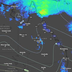
National Synoptic Situation
National Temperature and Rainfall

Rain typically refers to steady, continuous precipitation that lasts for a longer period, sometimes hours or even days. It can vary in intensity, but it's usually more consistent and widespread.
Showers, on the other hand, are shorter bursts of rain, often intermittent. They can be heavy but usually don't last long. Showers are more sporadic and may be followed by dry periods or other types of weather, like sun or clouds.
National Synoptic Situation
QLD:
Prepare yourselves, Queenslanders, for a wild weather ride ahead! A trough over the northwest to central interior of Queensland is going to do a disappearing act and head on over to central Australia where it will weaken like a deflating balloon. Meanwhile, a ridge over eastern Queensland is going to stick around for a while, getting stronger as the week goes on thanks to a high hanging out in the Tasman Sea. Keep an eye out for a trough in the far northern Coral Sea, making its way up to Torres Strait later this week. And don't worry about any tropical low that may form in the northern Coral Sea - it's expected to stay far away from our coast, just chilling out in the ocean. So grab your umbrellas and sunscreen, folks, and get ready for some interesting weather patterns coming your way!
NSW and ACT:
Well, it looks like Mother Nature is up to her old tricks again in NSW. A high pressure ridge is stretching across the state, while a cold front is causing a stir down south. Keep an eye out for a trough forming along the north coast tonight, where it will decide to camp out until the weekend rolls around. And just when you thought it was safe to go outside, another cold front is set to crash the party in the south and east over the weekend. But fear not, a broad high pressure ridge is expected to swoop in next week and bring some much-needed stability to the weather. So grab your umbrella and sunscreen, folks, it's going to be a wild ride!
VIC:
Well, it looks like our friend, the high pressure system, is really showing off its power down south in Western Australia. It's decided to extend its reach over Victoria, creating a high pressure ridge that will slowly make its way east over the Bight, then saunter across Bass Strait and into the Tasman Sea by Friday. But wait, there's more! A trough and cold front are gearing up to crash the party from the west on Saturday, with plans to sweep across the state on Sunday. So get ready for some wild weather antics coming our way this weekend. Time to batten down the hatches and break out the umbrellas!
SA:
It appears we have a high pressure system hovering over the southern waters of Western Australia, stretching a ridge over the southern waters of South Australia. This high seems to have big plans as it will casually saunter eastwards over the next few days, eventually deciding to make itself at home over the Tasman Sea by Friday. But wait, there's more! A trough and cold front are set to crash the high's party and make their way across South Australia from the west over the weekend. Just when you thought it couldn't get any more exciting, another high is expected to show up fashionably late over the Bight early next week. So, in summary, buckle up folks, we've got a high pressure system taking a leisurely stroll, a trough and cold front looking to stir things up, and another high planning to crash the party. It's like a soap opera in the sky, but with a chance of rain and wind. Stay tuned for updates!
WA:
Well, well, well, looks like a broad trough has decided to grace us with its presence over the northern parts of the state. How delightful. Time to break out the galoshes and umbrellas, folks. This trough is here to stay for a bit, so might as well get cozy and enjoy the slightly cooler temperatures it brings. Remember, a trough is just Mother Nature's way of keeping us on our toes and reminding us that weather can be quite unpredictable. So, stay informed and prepared for whatever this trough decides to throw our way.
TAS:
Well, it seems like Tasmania is in for a bit of a windy week ahead. A high in the Bight will be sending a southwesterly airstream our way, but don't worry, the winds should ease up as a ridge builds over the State on Thursday. By Friday, the high will have moved into the Tasman Sea, bringing with it some northeasterly winds. And just when you thought it couldn't get any more exciting, an approaching cold front is set to cross Tasmania on Sunday. So, hold onto your hats and batten down the hatches, it's going to be a wild ride!
NT:
So, we've got a trough chilling out over the central districts, while a ridge is playing traffic cop and sending some dry southeasterly winds down to the southern parts of the NT. And just to keep things interesting, another trough is planning to crash the party in the southern districts over the weekend. So, grab your umbrellas and sunscreen, folks, it's gonna be a wild ride!
National Weather Warnings
New South Wales
Victoria
Queensland
Western Australia
South Australia
Tasmania
Northern Territory
No warnings available at this time for Northern Territory.
National Storms and Rain Accumulation outlook


Four Day Forecasts
If you run a business and would like the benefits of a Big Shout plus your business promoted for 365 days, head here to take out a Bold Shout for $250.


NQ Rainfall 24 Accumulated (ACCESS G)


Temperature and Rainfall Forecast - Access-G

Thursday, 20th February
Grab your sunglasses if you're in the far southwest, because it's mostly sunny there. But if you're in the Peninsula, Gulf Country, or the northern and central interior west of Georgetown and Tambo, you might want to pack an umbrella - there's a chance of isolated to scattered showers and thunderstorms. Showers could even become widespread at times north of Coen, so keep an eye on those clouds. In the southeast, there's a possibility of isolated showers with potential thunderstorms, while showers are expected to be scattered near the central and southeast coasts. Don't forget your jacket, as temperatures are looking above average in the northwest interior and parts of the southwest, and near or slightly below average elsewhere. And as for the wind, expect light to moderate east to southeasterly breezes, with a shift to south to southeasterly in western Queensland and west to southwesterly over the northern Peninsula. So, if you're planning any outdoor activities, make sure to check the forecast and dress accordingly. Stay dry out there, folks!
Friday, 21st February
Grab your umbrellas and sunscreen, folks! Today's forecast includes partly cloudy skies in the southwest, central, and southern interior - perfect for a picnic or a leisurely stroll. But watch out for isolated showers popping up in other areas, with scattered rain along the east coast. And don't be surprised if you hear a rumble of thunder in the Peninsula, Gulf Country, and the northern and central interior - just nature's way of keeping you on your toes. Strong southeasterly winds will be making an appearance along the east coast, so hold onto your hats! And if you're up north near Weipa, be prepared for some widespread showers. As for temperatures, it's a mixed bag - above average in the western interior and western Peninsula, slightly below average in the east, and just right elsewhere. So grab your layers and be ready for whatever Mother Nature throws your way!
Saturday, 22nd February
Grab your sunscreen and umbrella, folks! It's mostly sunny in the interior south of Hughenden, but don't let that fool you - isolated to scattered showers are lurking elsewhere. Keep an eye out for isolated thunderstorms north of Burketown and Coen, as well as along the east coast north of Bowen. Showers may even decide to throw a party and become widespread at times about the North Tropical Coast. Don't forget about those fresh, gusty southeasterlies along the east coast - they're the life of the party. As for temperatures, they're feeling a bit above average in the west and Peninsula, while the east is playing it cool with near or slightly below average temps. Stay prepared and stay dry out there!
Sunday, 23rd February
Grab your sunscreen and umbrella, folks! Mother Nature is giving us a mixed bag of weather today. It's mostly sunny in the interior south of Hughenden, so pack your shades and get ready to soak up some vitamin D. But don't let your guard down, because isolated to scattered showers are popping up elsewhere. And if you're north of Cairns, be on the lookout for isolated thunderstorms making an appearance. Showers might even get a little rowdy and spread out at times from Cairns to Kowanyama. So hold onto your hats, because those fresh, gusty southeasterlies along the east coast are no joke. And when it comes to temperatures, the west is feeling the heat with above-average highs, while the east is keeping it cool with near or slightly below-average temps. Stay prepared and stay safe out there, folks!
Region Round-up - BOM
Forecast for North Tropical Coast and Tablelands:
Well, looks like Mother Nature might be feeling a bit indecisive today with a mix of clouds and a chance of showers. So, don't forget your umbrella if you're venturing out in the late morning or afternoon. The winds will be coming from the east to southeasterly direction at a brisk 20 to 30 km/h, so hold onto your hats! As for temperatures, you can expect a mild night with lows between 19 and 24 degrees. Daytime will be a bit warmer, reaching highs of 28 to 33 degrees. So, maybe pack a light jacket just in case you get chilly in the evening. And don't you dare forget your sunscreen! The UV Index is predicted to reach a whopping 13, which is considered extreme. So, slap on that sun protection from 8:30am to 4:30pm if you don't want to end up looking like a lobster. Stay safe out there, folks!
Location | Icon | Min Temp (°C) | Max Temp (°C) | Description |
Cairns | ⛅ | 24 | 32 | Partly cloudy. |
Atherton | ⛅ | 19 | 28 | Partly cloudy. |
Cooktown | 🌧 | 25 | 33 | Shower or two. |
Innisfail | 🌧 | 24 | 31 | Shower or two. |
Mareeba | ⛅ | 21 | 31 | Partly cloudy. |
Forecast for Herbert and Lower Burdekin:
Looks like we've got a classic case of sunny-some-rainy weather on our hands today. Light winds will be making an appearance, shifting from the west to the east as the day goes on. Temperatures will be doing their usual dance, with a cool overnight low and a toasty high during the day. Don't forget your sunscreen, folks! The UV index is predicted to hit extreme levels, so be sure to protect yourself from those pesky rays.
Location | Icon | Min Temp (°C) | Max Temp (°C) | Description |
Townsville | 🌧 | 24 | 32 | Shower or two. |
Ayr | 🌧 | 23 | 31 | Shower or two. |
Ingham | 🌧 | 23 | 31 | Shower or two. |
Forecast for Central Coast and Whitsundays:
Grab your umbrella and sunscreen, folks! We've got a medium chance of showers coming our way, most likely in the late morning and afternoon. Light winds will be making a shift to east to southeasterly at 15 to 25 km/h in the morning. Overnight, temperatures will drop to the low 20s, with daytime temperatures reaching around 30. Sun protection is a must from 8:20am to 4:10pm, as the UV Index is predicted to reach a whopping 13 [Extreme]. Mother nature is definitely keeping us on our toes today!
Location | Icon | Min Temp (°C) | Max Temp (°C) | Description |
Mackay | 🌧 | 23 | 30 | Possible shower. |
Bowen | 🌧 | 24 | 31 | Possible shower. |
Forecast for Peninsula:
Grab your umbrella and sunscreen, folks! We've got a mixed bag of weather coming our way. There's a high chance of showers up north, so make sure you've got your raincoat handy. And don't forget about the slight chance of a thunderstorm - Mother Nature likes to keep us on our toes. Expect light winds in the morning, followed by a shift to the east to southeasterly breeze. Overnight temps will drop to the low to mid 20s, while daytime temps will climb to a toasty 30 to 35 degrees. Sun protection is a must from 8:40am to 4:40pm, with an extreme UV Index of 14 predicted. So slap on that sunscreen and stay safe out there!
Location | Icon | Min Temp (°C) | Max Temp (°C) | Description |
Weipa | 🌧 | 23 | 31 | Showers. Possible storm. |
Coen | 🌧 | 24 | 33 | Shower or two. |
Palmerville | ⛅ | 22 | 33 | Partly cloudy. |
Thursday Island | 🌧 | 24 | 30 | Showers. Possible storm. |
Forecast for Gulf Country:
Expect a mix of clouds and possible showers, mainly in the western regions with a slight chance of rain elsewhere. There's even a chance of a thunderstorm to really spice things up. Winds will start off light before deciding to switch things up to a breezier east to northeasterly direction in the morning, only to calm down again by midday. Overnight, temperatures will cool down to the low to mid 20s, while daytime highs will soar to the mid to high 30s. Don't forget your sunscreen from 8:50am to 4:40pm, as the UV Index is predicted to reach a whopping 13 [Extreme]. So, keep an eye out for those clouds and pack an umbrella, just in case Mother Nature decides to have a little fun with us today.
Location | Icon | Min Temp (°C) | Max Temp (°C) | Description |
Normanton | ⛅ | 25 | 34 | Partly cloudy. |
Burketown | 🌧 | 25 | 34 | Shower or two. Possible storm. |
Doomadgee | 🌧 | 25 | 36 | Shower or two. Possible storm. |
Kowanyama | 🌧 | 23 | 34 | Possible shower. |
Forecast for Northern Goldfields and Upper Flinders:
Grab your sunglasses and sunscreen because it's going to be a mostly sunny morning. There's a slight chance of a shower later on, but don't worry, it's nothing to dampen your spirits. Keep an eye on the west for a potential thunderstorm in the afternoon and evening - just nature's way of adding a little excitement to your day. The winds will be coming from the north to northeasterly at a gentle 15 to 20 km/h, turning easterly later on. Overnight, temperatures will drop to a comfortable 19 to 24 degrees, so you can snuggle up with a light blanket and dream of sunnier days ahead. During the day, temperatures will rise to a toasty 31 to 37 degrees, so make sure to stay hydrated and find some shade if you start to sizzle. Sun protection is a must from 8:30am to 4:20pm, with the UV Index predicted to reach a whopping 13 - that's extreme, folks. So lather up and enjoy the sunshine while it lasts!
Location | Icon | Min Temp (°C) | Max Temp (°C) | Description |
Charters Towers | ⛅ | 21 | 33 | Partly cloudy. |
Georgetown | ⛅ | 21 | 34 | Partly cloudy. |
Forecast for Capricornia:
Looks like we've got some clouds rolling in, with a decent chance of rain later on. Wind will be light at first, but then it'll pick up speed in the afternoon. Make sure to hold onto your hats! Temperatures will drop overnight, so grab a blanket if you're heading out. Daytime will be a scorcher, reaching the low 30s. Don't forget your sunscreen, the sun will be intense from 8:10am to 4:00pm. UV Index is predicted to hit 12, so maybe wear a hat or hide in the shade if you're feeling a bit delicate.
Location | Icon | Min Temp (°C) | Max Temp (°C) | Description |
Gladstone | 🌧 | 23 | 31 | Possible shower. |
Rockhampton | 🌧 | 23 | 31 | Shower or two. |
Biloela | ⛅ | 20 | 33 | Partly cloudy. |
Yeppoon | 🌧 | 25 | 29 | Shower or two. |
Forecast for Central Highlands and Coalfields:
Looks like we've got a bit of cloud cover today, with a slim chance of a shower popping up, mainly in the late morning and afternoon. Watch out for a potential thunderstorm down in the southeast - you might want to bring an umbrella just in case. The winds will be light, starting off from the east at 15 to 20 km/h before calming down in the evening. Overnight, temperatures will drop to a balmy 19 to 22 degrees, while daytime highs will hit the low 30s. Keep that sun protection handy from 8:20am to 4:20pm, as the UV Index is expected to reach a whopping 13 - definitely in the extreme range. So grab your sunscreen and maybe a light jacket for those possible showers, and you'll be all set to tackle whatever Mother Nature throws your way today.
Location | Icon | Min Temp (°C) | Max Temp (°C) | Description |
Emerald | ⛅ | 22 | 32 | Partly cloudy. |
Clermont | ⛅ | 21 | 31 | Partly cloudy. |
Moranbah | ⛅ | 20 | 31 | Partly cloudy. |
Forecast for Central West:
Prepare your sunscreen and umbrellas, folks! It looks like we have a mix of clouds, a slight chance of rain, and even a potential thunderstorm later in the day. Don't let those north to northeasterly winds of 15 to 20 km/h catch you off guard - they'll be light in the middle of the day but then pick up again in the early afternoon. Overnight, temperatures will drop to the low to mid 20s, with daytime highs ranging from 33 to a scorching 39 degrees. Make sure to practice moderate sun protection from 8:40am to 4:40pm, as the UV Index is predicted to reach a whopping 13 - that's extreme, folks! Stay safe out there and don't forget your sun hat.
Location | Icon | Min Temp (°C) | Max Temp (°C) | Description |
Longreach | 🌧 | 25 | 38 | Possible shower. |
Barcaldine | ⛅ | 25 | 35 | Partly cloudy. |
Winton | ⛅ | 26 | 39 | Partly cloudy. |
Forecast for North West:
Prepare for a day of mostly sunny skies with a sprinkle of potential rain near Mt Isa. Don't worry, the rest of us won't be getting any of that precious moisture. There's even a slight chance of a thunderstorm to keep things interesting. Expect light winds in the morning, gradually shifting to a more confusing direction by the early afternoon. Temperatures will be hot enough to make you question your life choices, with overnight lows in the low to mid 20s and daytime highs reaching a scorching 37 to 42 degrees. Sun protection is a must from 8:50am to 4:50pm, with the UV Index expected to hit a whopping 14 - that's Extreme for those keeping score at home.
Location | Icon | Min Temp (°C) | Max Temp (°C) | Description |
Mount Isa | ⛅ | 24 | 39 | Partly cloudy. |
Forecast for Channel Country:
Expect a bright start to the day, followed by the potential for a thunderstorm in the northeast later on. Winds will be doing their thing, starting from the south and then switching to the southeast, picking up speed as they go. Temperatures will drop overnight to the low to mid 20s, only to soar back up to around 40 during the day. Don't forget your sun protection between 8:50am and 4:50pm, as the UV Index is expected to hit a whopping 14 (Extreme). So, slap on that sunscreen and hold onto your hats!
Location | Icon | Min Temp (°C) | Max Temp (°C) | Description |
Birdsville | ☀️ | 23 | 39 | Sunny. |
Thargomindah | ☀️ | 22 | 37 | Sunny. |
Forecast for Maranoa and Warrego:
Get ready for a day of sunshine with a side of thunderstorms in the east. Winds will be doing some acrobatics, starting off from the northeast to southeasterly before doing a little dance to the north to northeasterly, and then finally settling on east to southeasterly. Overnight temperatures will drop to a balmy 17 to 21 degrees, while daytime temperatures will soar into the mid to high 30s. Make sure to slap on some sunscreen between 8:20am and 4:10pm, as the UV Index is predicted to reach a whopping 13 (Extreme). So, grab your sunglasses and maybe an umbrella, just in case Mother Nature decides to throw a tantrum.
Location | Icon | Min Temp (°C) | Max Temp (°C) | Description |
Charleville | ☀️ | 19 | 37 | Sunny. |
Roma | ⛅ | 20 | 35 | Partly cloudy. |
St George | ⛅ | 19 | 35 | Partly cloudy. |
Cunnamulla | ☀️ | 19 | 37 | Sunny. |
Forecast for Darling Downs and Granite Belt:
Looks like we've got a bit of everything today - a sprinkle of showers, a dash of thunderstorms, and a pinch of sun. Don't forget your umbrella and sunscreen, because you never know what Mother Nature has up her sleeve. And make sure to hold onto your hats, because those easterly winds are going to keep you on your toes. Overnight, temperatures will dip down to a cozy 17 to 21 degrees, while daytime temperatures will sizzle between 29 to 34 degrees. So, slap on that sun protection from 8:10am to 3:50pm, because the UV Index is predicted to reach an extreme 12. Stay safe out there, folks!
Location | Icon | Min Temp (°C) | Max Temp (°C) | Description |
Dalby | 🌧 | 19 | 29 | Possible shower. |
Goondiwindi | ⛅ | 21 | 33 | Partly cloudy. |
Toowoomba | 🌧 | 18 | 26 | Possible shower. |
Warwick | 🌧 | 17 | 29 | Shower or two. |
Stanthorpe | 🌧 | 16 | 25 | Shower or two. |
Forecast for Wide Bay and Burnett:
Looks like Mother Nature is feeling a bit indecisive today. We've got some clouds hanging around, a slim chance of rain popping up, and winds that can't make up their mind which way to blow. So, grab your sunscreen and keep an eye out for those brief showers in the late morning and afternoon. Temperatures will be dropping to a comfortable range overnight, but expect things to heat up to around 30 degrees during the day. And don't forget, the sun will be shining bright, so make sure to protect yourself from those extreme UV rays between 8:10am and 3:50pm. Stay dry, stay cool, and stay safe out there, folks!
Location | Icon | Min Temp (°C) | Max Temp (°C) | Description |
Bundaberg | 🌧 | 22 | 31 | Possible shower. |
Gympie | ⛅ | 20 | 30 | Partly cloudy. |
Hervey Bay | ⛅ | 22 | 30 | Mostly sunny. |
Kingaroy | ⛅ | 18 | 27 | Partly cloudy. |
Maryborough | ⛅ | 21 | 30 | Partly cloudy. |
Gayndah | ⛅ | 20 | 32 | Partly cloudy. |
Forecast for Southeast Coast:
Looks like we've got a little mix of sun and clouds today, with a slight chance of a shower popping up, mostly in the late morning and afternoon. If you're out west, watch out for a possible thunderstorm in the morning and afternoon - it's like a little bonus feature! Don't worry too much about the wind, it'll start off light and then pick up to a nice 15 to 25 km/h in the middle of the day. And as for temperatures, expect a low of 18 and a high of 22 overnight, with a toasty 30 degrees during the day. So make sure you've got your sunscreen handy, because that UV Index is predicted to hit a whopping 12 - extreme sun protection needed from 8:10am to 3:50pm. Stay safe out there, folks!
Location | Icon | Min Temp (°C) | Max Temp (°C) | Description |
Beaudesert | ⛅ | 19 | 30 | Partly cloudy. |
Brisbane | ⛅ | 22 | 30 | Partly cloudy. |
Gatton | ⛅ | 20 | 31 | Partly cloudy. |
Ipswich | ⛅ | 20 | 31 | Partly cloudy. |
Logan Central | ⛅ | 20 | 29 | Partly cloudy. |
Maroochydore | ⛅ | 22 | 29 | Partly cloudy. |
Redcliffe | ⛅ | 23 | 29 | Partly cloudy. |
Surfers Paradise | ⛅ | 21 | 29 | Partly cloudy. |
We run on positivity and our output is education for your peace of mind. Wally also runs on coffee so shout him a coffee today, just for for $5 each year, or one each month for a year for $55 https://wallysweather.com.au/community
National maps by Weatherzone (weatherzone.com.au)
State maps by Windy (Windy.com)
Weather forecast supplemented by Bureau of Meteorology (bom.gov.au)
Rainfall daily totals (https://meteologix.com/ )
AccuWeather (https://www.accuweather.com/)
Nine Weather (https://www.9news.com.au/weather)
Wally's Weather provides professionally researched data and information. Andrew aka 'Wally' has over 20 years of experience in meteorology research and data analysis. In 2023 finished top 4 for the AMOS national weather forecasting competition. The content here is provided as educational information aimed at providing the community and businesses with the tools required to determine local-based forecasts. IMPORTANT: The forecasts and information posted should never be used on their own to make business decisions as local influences.


Comments