Feb 25 2025 - Townsville Daily
- Feb 25, 2025
- 2 min read
Welcome to the new Townsville Daily forecast. This is specific for the Townsville region only.

Luxury vehicle specialist towing service. When it comes to premium vehicles, trust matters. At Old Mate's Towing, we treat every vehicle with the care it deserves.
Ph: +61 457 085 640
Facebook: https://www.facebook.com/oldmatestowing
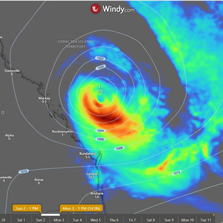
Queensland Synoptic
Queensland will be under the persistent influence of a ridge, thanks to a high sneaking into the Tasman Sea, while Tropical Cyclone Alfred is off causing mischief in the Coral Sea and may decide to pay us a visit later on. Meanwhile, a trough might crash the party in the far southwest on Friday and stick around for the weekend before a new high shows up in the Tasman Sea next week.
Forecast for Herbert and Lower Burdekin:
Looks like we've got a mix of sun and clouds today, with a slim chance of a shower popping up later on. The winds will be blowing from the southeast at a moderate pace, but they'll calm down by the evening. Expect temperatures to dip to the high teens to low 20s overnight, but don't worry - we'll be back in the toasty low to mid 30s during the day. Time to break out the sunscreen and maybe keep an umbrella handy, just in case!
Forecast for Herbert and Lower Burdekin:
Warnings
Townsville hourly
Townsville 7 Day daily
Region 24 Hour Accumulated
Monsoon Special:
The next monsoon pulse due in Phase 6 (Gulf to Coral Sea) around the 26th March to 2nd April. Due to the 3rd pulse normally being weak, it tends to come around quicker so could be a week earlier.
I'm extending my forecast just one more day, looking about 7 days ahead now, which is usually beyond my typical range since forecasts beyond 4 days tend to be inconsistent. However, I want to illustrate just how inconsistent they can be.
Yesterday, two systems were projected to be close to land by the 2nd. Today, only one remains near land, while the other two have shifted further away. We’ll likely see these shifts continue until the end of tomorrow, after which the models should start to align more on where these systems will be 4 days from tomorrow.
So today a crossing is again uncertain, and so we wait till tomorrow to get to the point of being 4 days out from a possible crossing or drive by as I have mentioned, where we see it follow the coast down, creating strong swell and causing erosion and potential heavy rain depending how far off shore it is.


ACCESS C 3 Hourly


Comments