Morning Weather - April 12 - Wally's Weather Australia
- Apr 11, 2024
- 1 min read
To get your daily forecast delivered free goto http://wallysweather.com.au/blog
 Our products include tyres, rims, trailer parts and accessories, automotive lights and much more! We stock quality brands like Michelin, BF Goodrich to name a few. Our services include suspension, tyre-fitting, tyre repairs, wheel balancing, wheel alignment and much more! We pride ourselves on quality workmanship to ensure your car is in the best condition for safe travelling!! Website: https://jmtyre.com.au/ Facebook: https://www.facebook.com/GOLDINVESTMENTGROUPTOWNSVILLE Phone: (07) 4721 5599 |
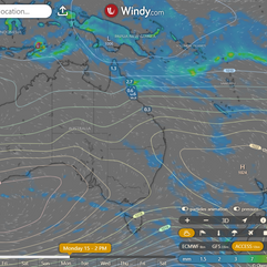
Monsoon Update I bet you thought the monsoon was over, but we normally get 3 pulses, in fact this technically is the 4th. But this one swung around a month earlier, although in reality it didn't swing around, it just never left. This season the monsoon pulse has been strong with us, here in Australia. Although we are still under the average for the country.  TC Paul has reached Cat 2 and is expected to weaken tomorrow into a Cat 1 as it circles from moving SE to NW. It was expected to be travelling NW today but hasn't done so.  Current conditions show moderate vertical wind shear (15-20 knots), warm sea surface temperatures (29-30°C), and moderate eastward outflow, with dry air entrainment affecting the system. Initial analysis indicates high confidence in position and moderate confidence in intensity and wind radii. Tropical Cyclone 22P is expected to slow and turn southeastward in the next 12 hours before accelerating west-northwestward due to a developing high-pressure ridge, ultimately weakening rapidly and dissipating within 48 hours due to dry air and increasing wind shear. Model guidance supports this forecast, with some uncertainty in short-term track due to erratic motion. |
National Expect showers and storms to impact the northern tropics and the southern and inland regions of WA due to moist and unstable winds. Coastal showers along the eastern seaboard, southern Vic, and SA will be driven by an onshore flow. TAS will experience showers from an approaching front, while high pressure systems will maintain dry conditions elsewhere. Synoptic | Temp/Rain | Wind | Sea Surface Temp |
The 4 day forecast brought to you by our local businesses, you could have this spot with your details, support local, take out a Bold Shout! $250 for a year, you get this and the website every day! |
4 Day Forecast
|
Warnings
Storms - Extreme Weather - Fire danger |


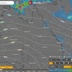
State Tropical Cyclone Paul in Coral Sea will slow down, then become a tropical low. High pressure will bring moisture to east coast. Low in Tasman Sea will cool down southern Queensland. Weak trough expected in western Queensland next week. ACCESS (Values are rainfall over 3 hours) |


State Region Round-up North Tropical Coast and Tablelands: Max temperature: 30°C, min temperature: 14°C, wind speed: 20-30 km/h (east-southeasterly), rainfall: slight chance of shower afternoon/evening. Herbert and Lower Burdekin: Max temperature: 30°C, Min temperature: 13-18°C, Wind speed: 15-25 km/h, Wind direction: East, Rainfall: Slight chance along coastal fringe, Other: Partly cloudy, light winds becoming southeasterly in the morning. Central Coast and Whitsundays: Mostly sunny with slight chance of a shower near coastal fringe, max temp around 30, min temp between 14-19, south to southeasterly winds 15-20 km/h tending east to southeasterly 20-30 km/h in the morning, near zero rainfall. Peninsula: Mostly sunny with slight chance of shower, max temp in low to mid 30s, min temp between 18-24, easterly winds 20-30 km/h becoming light, near zero rainfall. Gulf Country: Max temperature: low 30s, Min temperature: 15-21, Wind speed: 25 to 35 km/h becoming light, Wind direction: South to southeasterly to east, Rainfall: None, Other: Sunny. Northern Goldfields and Upper Flinders: Max temperature: 30°C, Min temperature: 12-16°C, Wind speed: 15-25 km/h, Wind direction: easterly, Rainfall: None, Conditions: Sunny. Capricornia: Max temperature: 30°C, Min temperature: 12-18°C, Wind: Light becoming east to southeasterly 15-25 km/h, Rainfall: Slight chance of a shower near the coast, Partly cloudy. Central Highlands and Coalfields: The weather for the day will have a maximum temperature of around 30 degrees Celsius, with minimum temperatures between 9 and 13 degrees, light winds becoming southeasterly in the morning and shifting to easterly (15 to 25 km/h), and possible rainfall, with sunny conditions prevailing. Central West: Max temperature: 30°C, Min temperature: 9-12°C, Wind speed: 15-20 km/h, Wind direction: Southeasterly/ easterly becoming light, Rainfall: None, Other: Sunny. North West: The maximum temperature will reach the low 30s with southeasterly winds of 20 to 30 km/h becoming light, a chance of rainfall, and overnight temperatures dropping to 11-15 degrees. Channel Country: Max temperature: 30°C, Min temperature: 10-13°C, Wind speed: southeasterly 15 to 25 km/h, Wind direction: southeasterly, Rainfall: No rainfall expected, Other: Sunny. Maranoa and Warrego: Max temperature in the mid to high 20s, min temperature between 8 and 11, light winds, sunny weather with no rainfall. Darling Downs and Granite Belt: The weather will be mostly sunny with light winds in the morning becoming northeast to southeasterly 15 to 20 km/h, then becoming light in the middle of the day, with overnight temperatures around 11°C dropping to the mid to high 20s during the day. Wide Bay and Burnett: Max temperature in the mid to high 20s, min temperature between 11 and 17, light winds becoming southeasterly 15 to 25 km/h, medium chance of showers along coastal fringe and slight chance elsewhere under partly cloudy skies. Southeast Coast: Expect daytime temperatures in the mid to high 20s with overnight temperatures dropping to between 13 and 17, southerly winds at 15 to 20 km/h, a slight chance of showers inland and a medium chance of showers along the coast, and mostly sunny skies. |
Click here to support to Wally's Weather
National maps by Weatherzone (weatherzone.com.au)
State maps by Windy (Windy.com)
Weather forecast supplemented by Bureau of Meteorology (bom.gov.au)
Rainfall daily totals (https://meteologix.com/ )
AccuWeather (https://www.accuweather.com/)
Nine Weather (https://www.9news.com.au/weather)
Wally's Weather provides professionally researched data and information. Andrew aka 'Wally' has over 20 years of experience in meteorology research and data analysis. In 2023 finished top 4 for the AMOS national weather forecasting competition. The content here is provided as educational information aimed at providing the community and businesses with the tools required to determine local-based forecasts. IMPORTANT: The forecasts and information posted should never be used on their own to make business decisions as local influences.


Comments