Morning Weather - August 27 - Wally's Weather Australia
- Aug 27, 2023
- 3 min read
This weather update is brought to you by Pandanus Park Golf Centre

Pandanus Park Golf Centre is located at 2 Tompkins Road, Shaw (opposite the RSPCA) and is Townsville’s only day and night driving range.
Check out their VIDEO!
National
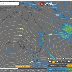
Tasmania's high extends a ridge over the state, moving slowly east and reaching the Tasman Sea today. A weak, lingering trough in southern Queensland strengthens Wednesday, moving east across Queensland Thursday, pushing offshore Friday. A low may develop in the Coral Sea late next week. Southern Australia's high crosses from Thursday, extending a new ridge and potentially reaching the Tasman Sea.


State
High near Tasmania extends ridge over state. High will move east, maintaining ridge. Weak trough lingers over southern Queensland, strengthens on Wednesday. Trough moves east across southern and central Queensland. Trough moves into eastern districts on Thursday, pushing offshore on Friday. Low may develop in Coral Sea late next week. High crosses southern Australia, extends new ridge over state. High may reach Tasman Sea late next week.


4-day
Monday: Eastern districts will have isolated showers, which may become scattered over the North Tropical Coast and the Southeast Coast District at times. The Torres Strait will also experience isolated showers. The southern and central interior will be partly cloudy, while the rest of the region will be mostly sunny. In the eastern districts south of Gayndah, there will be morning fog. Maximum temperatures will be close to the average in the north of Hughenden and along the east coast, but above average elsewhere. Minimum temperatures will be above average in the southern interior and southwest, and close to the average everywhere else.
Tuesday: Isolated showers in east and central districts south of Rockhampton. Chance of thunderstorms along the east coast south of Gladstone. Isolated showers in North Tropical Coast and Torres Strait. Mostly sunny in other areas. Morning fog in eastern districts from Ingham to Gladstone. Near average maximum temperatures in north of Hughenden and east coast, above average elsewhere, and well above average in southwest. Above average minimum temperatures in southern interior and southwest, near average elsewhere.
Wednesday: Scattered showers, chance of thunderstorm in south and central areas east of Quilpie. Partly cloudy in North Tropical Coast, mostly sunny elsewhere. Morning fog in east and central areas south of Ingham. Temperatures near average north of Charters Towers and east coast, above average elsewhere, and well above average in the southwest. Minimum temperatures above average in southern interior and southwest, near average elsewhere.
Thursday: Scattered showers with chance of thunderstorms in southern and central districts east of Charleville. Thunderstorms moving offshore from Friday. Sunny elsewhere. Above-average maximum temperatures on Thursday, then near average from Friday. Near-average minimum temperatures in southeast, below average elsewhere, and well below average in the far west from Friday.


Townsville
Max 28° Mostly sunny. 5% Rain. Mostly sunny. Light winds, E-SE 20-30 km/h AM, light late evening.
Herbert and Lower Burdekin
Max 27° Mostly sunny. 5% Rain. SE 15-20 km/h, E 20-30 km/h AM, E-SE light late evening.
North Tropical Coast and Tablelands
Max 25° Possible shower. 40% Rain. Partly cloudy. Med coast shower chance, slight elsewhere. E-SE winds 25-40 km/h.
Cairns
Max 26° Shower or two. 60% Rain. Partly cloudy. Med chance of showers. SE winds 20-30 km/h, increasing to 25-40 km/h midday.
Mackay
Max 25° Sunny. 10% Rain. Sunny. SE winds 20-30 km/h.
Northern Goldfields
Max 30° Sunny. 0% Rain. E winds 25-35 km/h.
Mt Isa
Max 31° Sunny. 0% Rain. Light winds, E-SE 15-20 km/h AM, light evening.
Click here to support to Wally's Weather
National maps by Weatherzone (weatherzone.com.au)
State maps by Windy (Windy.com)
Weather forecast supplemented by Bureau of Meteorology (bom.gov.au)
Rainfall daily totals (https://meteologix.com/ )
Wally's Weather provides professionally researched data and information. Andrew aka 'Wally' has over 20 years of experience in meteorology research and data analysis. The content here is provided as educational information aimed at providing the community and businesses with the tools required to determine local-based forecasts. IMPORTANT: The forecasts and information posted should never be used on their own to make business decisions as local influences.


Comments