Morning Weather - August 8 - Wally's Weather Australia
- Aug 8, 2023
- 3 min read
This weather update is brought to you by Pandanus Park Golf Centre

Pandanus Park Golf Centre is located at 2 Tompkins Road, Shaw (opposite the RSPCA) and is Townsville’s only day and night driving range.
Check out their VIDEO!
National
Southeastern Australia's high extends ridge, moves east to Tasman Sea on Wednesday. Ridge weakens as high drifts northeast, trough moves across Queensland on Thursday and Friday. Ridge weak next weekend, possibility of trough in southern Queensland next week.


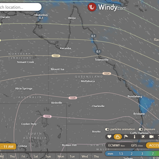
State
A high over southeastern Australia will slowly move east towards the Tasman Sea. The ridge will weaken, and a trough will move across southern Queensland, gradually weakening as it moves offshore. A weak ridge will extend over the state next weekend, and another trough might move into southern Queensland next week.


4-day
Wednesday: Eastern coast and Torres Strait: Isolated to scattered showers. Mostly sunny elsewhere. Morning frost inland in southern Queensland. Above average max temperatures in southwest, near average elsewhere. Minimum temperatures near average.
Thursday: East coast from Ingham to the Torres Strait: Isolated to scattered showers Hervey Bay to Maroochydore: Isolated showers, Southern Queensland: Morning frost inland, Southeast Queensland: Morning fog inland, Southern interior and southwest: Above average maximum temperatures, Southeast inland: Below average minimum temperatures.
Friday: Scattered showers in north east, sunny elsewhere. Morning frost inland. Moderate westerly winds in southeast. Above average max temps in south, near average elsewhere. Similar min temps.
Monday: On Monday, expect isolated showers on the east coast north of Ingham and southeast coast south of Hervey Bay. The rest of the areas will be sunny. Southern Queensland will have morning frost inland. Maximum temperatures will be above average south of Charters Towers and near average elsewhere. Minimum temperatures will be below average inland in the southeast on Saturday and Sunday, near average elsewhere, and tending above average in the southwest on Monday.


Townsville
Max 27°C. Mostly sunny. Chance of rain: 0%. Winds S-SE 15-20 km/h, becoming NE-SE 15-25 km/h midday, then light in the evening.
Herbert and Lower Burdekin
Max 26°C. Mostly sunny. Chance of rain: 0%. Sunny. Winds E-SE 15-25 km/h, shifting to E-NE 15-20 km/h in the evening and light late evening.
North Tropical Coast and Tablelands
Max 23°C. Partly cloudy. Chance of rain: 20%. Partly cloudy. Med chance of coastal & nearby range showers. Winds E-SE 25-35 km/h.
Cairns
Max 25°C. Showers possible. Chance of rain: 50%. Partly cloudy. Med chance of showers, mainly AM. Winds SE 20-25 km/h, increasing to 25-35 km/h in the morning.
Mackay
Max 23°C. Mostly sunny. Chance of rain: 20%. Mostly sunny day, slight evening shower chance. Winds S-SE 20-30 km/h, becoming light late evening.
Northern Goldfields
Max 28°C. Sunny. Chance of rain: 0%. Sunny. Winds E 15-20 km/h, shifting to E-SE 20-30 km/h in the AM.
Mt Isa
Max 28°C. Sunny. Chance of rain: 0%. E-Sunny. Winds E 15-25 km/h, light in early PM.
Click here to support to Wally's Weather
National maps by Weatherzone (weatherzone.com.au)
State maps by Windy (Windy.com)
Weather forecast supplemented by Bureau of Meteorology (bom.gov.au)
Rainfall daily totals (https://meteologix.com/ )
Wally's Weather provides professionally researched data and information. Andrew aka 'Wally' has over 20 years of experience in meteorology research and data analysis. The content here is provided as educational information aimed at providing the community and businesses with the tools required to determine local-based forecasts. IMPORTANT: The forecasts and information posted should never be used on their own to make business decisions as local influences.


Comments