Morning Weather - December 28 - Wally's Weather Australia
- Dec 27, 2023
- 5 min read
This weather update is brought to you by Genesis Electrical NQ

Genesis Electrical NQ
We can Solve all of your Electrical, Air Conditioning and Solar needs!
Phone: 1300 443 637
Email: info@genesislec.com
Special report
WEATHER WARNINGS
Severe Thunderstorm Warning (Damaging Winds, Large Hail & Heavy Rainfall) for Capricornia, Southeast Coast & Central Highlands & Coalfields.
Severe Thunderstorm Warning - Southeast Queensland (Damaging Winds & Large Hailstones) for Logan, Scenic Rim & Gold Coast Council Areas.
Strong Wind Warning for Thursday for Eden Coast.
Strong Wind Warning for Pilbara Coast East, Perth Local Waters & Perth, Bunbury Geographe, Leeuwin, and Albany coasts.
Strong Wind Warning for Thursday for Spencer Gulf, Investigator Strait & Far West, Upper West, Lower West, and Central coasts.
Strong Wind Warning Thursday Banks St & Franklin Sound, East of Flinders Is, Fred Hen Bay & Norfolks, Storm, Channel & CN, UE, L E, SE.
Update Of Minor Flood Warning For The Bunyip River.
Final Flood Warning For The Don River.
Initial Minor Flood Warning For The Barwon River.
Moderate Flood Warning For The Avoca River.
Final Flood Warning For The Logan River.
Minor Flood Warning For The Moonie River.
Final Flood Watch For Gippsland, North West, South West, Central And North East Victoria.
Final Flood Warning For The Werribee River.
Minor Flood Warning For The Loddon River.
Minor Flood Warning For The Paroo River (Qld).
Minor Flood Warning For The Paroo River (Nsw).
.

Peak of the storms
National
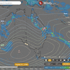
Troughs and lows expected to bring showers and thunderstorms to various regions, including the tropics, interior, southern SA, and east/northeast NSW. Heat anticipated ahead of troughs, leading to extreme heat in southeast QLD. A front likely to trigger some showers in the southeast.


Synoptic | Temp/Rain | Wind | Sea Surface Temp
State
A trough is weakening over western, central, and southern Queensland. An upper trough is causing showers and thunderstorms in eastern Queensland and will move away on Thursday. The surface trough will become a broad low pressure area on Thursday and Friday, while a weak ridge will be along the east coast. A new trough will come on the weekend, with an upper trough system making it stronger. A weak ridge will be along the east coast from Sunday due to a high in the Tasman Sea. The surface trough may weaken on Tuesday when the upper trough moves away.

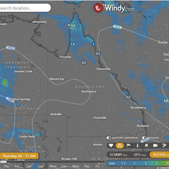


ACCESS 3Hour Rainfall
4-day
Thursday: Scattered showers and thunderstorms in eastern and northern Queensland. Severe storms possible in eastern areas. Clear in southwest. Variable winds. Heatwave in northwest, interior, and southeast.
Friday: Isolated showers and chance of thunderstorm statewide, except far southwest. Showers in east districts between Cooktown and Townsville. Mostly sunny in southwest. Heatwave in north, west, and southeast. Max temps near average in Cape York Peninsula, well above average elsewhere.
Saturday: Isolated showers and thunderstorms except for the far southwest. Showers mainly in the east coast north of Ingham. Scattered to widespread showers south of Mackay and east of Charleville. Possible severe thunderstorms with damaging wind, hail, and heavy rainfall in those areas. Mostly sunny in the far southwest. Heatwave in the north and west. Above-average temperatures, especially inland west of Emerald.
Sunday: Sunday: Scattered showers and thunderstorms across the state, except for the far southwest. Only showers expected along the east coast north of Bowen. Showers widespread at times south of Mackay and east of Charleville. Mostly sunny in the far southwest. Heatwave conditions in the northwest. Above-average maximum temperatures in the North West and Central West Districts, and near-average temperatures in the southeast.


North Tropical Coast and Tablelands:
Max temperature: low to mid 30s, Min temperature: low to mid 20s, Wind speed: light, Wind direction: east to northeasterly, Rainfall: Partly cloudy with a medium chance of showers in the late morning and afternoon, Chance of a thunderstorm.
Herbert and Lower Burdekin:
Max temperature: 38, Min temperature: low to mid 20s, Wind speed: light, Wind direction: north to northeasterly, Rainfall: Slight chance of shower in the afternoon and evening, Sky: Partly cloudy with chance of thunderstorm in the late morning.
Central Coast and Whitsundays:
Max temperature: low to mid 30s / Min temperature: low to mid 20s / Wind speed: light winds becoming northerly 15 to 20 km/h / Wind direction: northerly / Rainfall: medium chance of showers in the afternoon and evening / Other: partly cloudy with a chance of a thunderstorm from the late morning.
Peninsula:
Max temperature: low to mid 30s, Min temperature: mid 20s, Wind speed: light, Wind direction: N/A, Rainfall: Partly Cloudy with high chance of showers in the north and medium chance elsewhere, Other: chance of a thunderstorm.
Gulf Country:
Max temperature of 37 to 43 with mostly sunny conditions, slight chance of a shower near east coast, near zero chance of rain elsewhere, chance of a thunderstorm in late morning, winds north to northwesterly 15 to 20 km/h tending north to northeasterly 15 to 25 km/h in the evening then becoming light in the late evening, overnight temperatures falling to the low to high 20s.
Northern Goldfields and Upper Flinders:
Max temperature: 36 to 43, Min temperature: low to mid 20s, Wind speed: light, Wind direction: N/A, Rainfall: slight chance of a shower in the north, near zero chance elsewhere, Other: Mostly sunny with a chance of thunderstorm in the afternoon and evening.
Capricornia:
Max temperature: low to high 30s, Min temperature: low to mid 20s, Wind speed: light winds becoming 15-20 km/h, Wind direction: north to northwesterly turning to north to northeasterly, Rainfall: medium chance of showers, possibly severe thunderstorm, other: Partly cloudy.
Central Highlands and Coalfields:
Mostly sunny with a slight chance of showers in the northeast, near zero chance elsewhere, chance of thunderstorm in the afternoon and evening, light winds, overnight temps between 19-24°C and daytime temps in the mid to high 30s.
Central West:
Max temperature: 43, Min temperature: 19, Wind: Light becoming northeast to southeasterly 15-20 km/h, Rainfall: None, Other: Sunny.
North West:
The weather will be sunny with light winds and temperatures falling to the low 20s overnight and reaching the low to mid 40s during the day, with a maximum temperature, minimum temperature, wind speed, wind direction, and rainfall not specified.
Channel Country:
The maximum temperature will reach the low to mid 40s with sunny conditions, light winds becoming south to southeasterly 15 to 20 km/h in the late afternoon then becoming light in the late evening. Overnight temperatures will fall to the low 20s.
Maranoa and Warrego:
Max temperature: 40°C, Min temperature: 18-21°C, Wind speed: 15-20 km/h, Wind direction: south to southwesterly, Rainfall: None, Other: Sunny.
Darling Downs and Granite Belt:
Max temperature in the mid to high 30s; Min temperature between 17 and 20; Wind speed: light winds becoming west to southwesterly 15 to 20 km/h then light; Rainfall: Sunny morning, chance of thunderstorm in the north in the afternoon and evening.
Wide Bay and Burnett:
Max temperature: low to high 30s, Min temperature: low 20s, Wind speed: Light becoming 15 to 20 km/h, Wind direction: West to NW, Rainfall: Partly cloudy with medium chance of showers near the coast and slight chance elsewhere, other: Chance of severe thunderstorm, winds tending NW to NE in the evening.
Southeast Coast:
Max temperature: low to high 30s, Min temperature: 19-23, Wind speed: west to northwesterly 15-20 km/h, Wind direction: northwest to northeasterly, Rainfall: Sunny morning, thunderstorms in afternoon and evening, possibly severe, Light winds in late evening.
Click here to support to Wally's Weather
National maps by Weatherzone (weatherzone.com.au)
State maps by Windy (Windy.com)
Weather forecast supplemented by Bureau of Meteorology (bom.gov.au)
Rainfall daily totals (https://meteologix.com/ )
AccuWeather (https://www.accuweather.com/)
Nine Weather (https://www.9news.com.au/weather)
Wally's Weather provides professionally researched data and information. Andrew aka 'Wally' has over 20 years of experience in meteorology research and data analysis. In 2023 finished top 4 for the AMOS national weather forecasting competition. The content here is provided as educational information aimed at providing the community and businesses with the tools required to determine local-based forecasts. IMPORTANT: The forecasts and information posted should never be used on their own to make business decisions as local influences.


Comments