Morning Weather - December 29 - Wally's Weather Australia
- Dec 28, 2023
- 5 min read
This weather update is brought to you by Genesis Electrical NQ

Genesis Electrical NQ
We can Solve all of your Electrical, Air Conditioning and Solar needs!
Phone: 1300 443 637
Email: info@genesislec.com
Special report
WEATHER WARNINGS
Strong Wind Warning for Spencer Gulf, Investigator Strait & Far West, Upper West, Lower West, Central, and South Central coasts.
Strong Wind Warning for Central North, Upper East & Lower East coasts.
Strong Wind Warning for Central Gippsland and East Gippsland coasts.
Strong Wind Warning for Eden Coast.
Severe Thunderstorm Warning (Damaging Winds) for parts of North West Pastoral district.
Fire Weather Warning for Swan Inland North and Swan Inland South.
Strong Wind Warning for Perth Local Waters & Lancelin, Perth, Bunbury Geographe, and Leeuwin coasts.
Minor Flood Warning For The Bunyip River.
Minor Flood Warning For The Paroo River (Qld).
Final Flood Warning For The Moonie River.
Minor Flood Warning For The Barwon River.
Minor Flood Warning For The Avoca River.
Minor Flood Warning For The Snowy River.
Minor Flood Warning For The Paroo River (Nsw).
Minor Flood Warning For The Loddon River.
Final Flood Warning For The Lower Barcoo River.
.

Peak of the storms
National
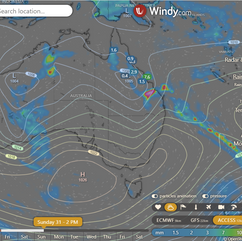
Troughs and lows in the north to bring showers and storms to north and eastern WA, western NT, eastern QLD, and NSW. Heat to persist across the interior and east due to the aforementioned weather systems. A front crossing Tasmania expected to bring light showers.
Onshore winds may trigger occasional showers and storms over southwest WA.


Synoptic | Temp/Rain | Wind | Sea Surface Temp
State
A weak trough stretches across Queensland, with a ridge along the east coast. Showers and thunderstorms will increase in eastern districts as a new trough moves across central and southern Queensland. The ridge along the east coast will strengthen slightly on Sunday. The surface trough may weaken on Tuesday as the upper trough moves away.


ACCESS 3Hour Rainfall
4-day
Friday: Isolated showers and thunderstorms in eastern and northern Queensland, becoming scattered at times in northwestern Cape York Peninsula. Severe thunderstorms possible with damaging wind gusts, heavy rainfall, and large hail from St Lawrence to Gympie. Clear in the southwest and central/southern interior. Light to moderate winds shifting direction.\
Saturday: Isolated showers and thunderstorms in central, east, and north districts. Only showers along the east coast north of Ingham. Scattered to widespread showers south of Rockhampton and east of Charleville. Severe thunderstorms likely inland southeast Queensland and possibly south of St Lawrence and east of Charleville. Damaging wind gusts, large hail, and heavy rainfall expected. Mostly sunny in far southwest. Heatwave conditions in north, west, and central interior districts, easing in southeast Queensland. Maximum temperatures above average, especially inland west of Emerald.
Sunday: Isolated showers, thunderstorms in NW, scattered east of Julia Creek to Charleville, showers in east coast north of Bowen. Showers widespread at times in central and southeast QLD south of Mackay. Severe thunderstorms possible in central and eastern districts south of Ingham and north of Sunshine Coast to Chinchilla. Sunny in far southwest. Heatwave in NW QLD. High temps in NW and Central West Districts. Temps near/below average in southeast, above average elsewhere.
Monday: Some showers and thunderstorms throughout the state, except for the far southwest. Showers only on the east coast north of Innisfail. Widespread showers in central and eastern districts north of Sunshine Coast and south of Charters Towers. Mostly sunny in the far southwest. Heatwave conditions in the northwest. Above average temperatures in the west, near average elsewhere.


North Tropical Coast and Tablelands:
Max temperature: low to mid 30s, Min temperature: low to mid 20s, Wind speed: becoming 15 to 20 km/h, Wind direction: east to northeasterly, Rainfall: None, Weather: Mostly sunny with light winds.
Herbert and Lower Burdekin:
Max temperature: 38, Min temperature: low to mid 20s, Wind speed: light, Wind direction: becoming northeasterly, Rainfall: chance of thunderstorm in south, Other: mostly sunny day, overnight temperatures falling.
Central Coast and Whitsundays:
The day will be mostly sunny, with a slight chance of a shower, becoming windy and with a chance of a thunderstorm in the afternoon and evening. Temperatures will range from the low to mid 20s overnight, reaching 32 to 37 during the day. Wind will start light and become north to northeasterly 15 to 20 km/h, becoming light again in the late evening.
Peninsula:
Max temperature: 38, Min temperature: mid 20s, Wind speed: light, Wind direction: east to northeasterly, Rainfall: slight chance, Other: mostly sunny, chance of showers, chance of thunderstorm.
Gulf Country:
The max temperature is 43 with a minimum temperature of mid-20s, wind speed of 15 to 25 km/h from north to northwesterly, chance of a thunderstorm, and mostly sunny conditions with a slight chance of a shower near the east coast.
Northern Goldfields and Upper Flinders:
Max temperature: 37 to 43, Min temperature: low to mid 20s, Wind speed: northwest to northeasterly 20 to 30 km/h becoming light, Wind direction: north to northeasterly 15 to 20 km/h in the late evening, Rainfall: Slight chance of a shower about the Gregory Ranges, near zero chance elsewhere, Other: Mostly sunny with a chance of a thunderstorm in the afternoon and evening.
Capricornia:
Max temp: 39°C, Min temp: low-mid 20s°C, Wind: light becoming N 15-20 km/h, Rain: slight chance shower, Thunderstorm chance in afternoon & evening, Mostly sunny.
Central Highlands and Coalfields:
Max temperature: high 30s; Min temperature: low to mid 20s; Wind: light, becoming north to northeasterly 15-20 km/h; Rain: slight chance of shower; Weather: Mostly sunny with chance of thunderstorm in late afternoon and evening.
Central West:
The weather will be hot with temperatures ranging from low to mid 20s overnight and daytime temperatures reaching 40 to 45, there will be light winds becoming northwest to northeasterly 15 to 25 km/h in the morning, with a chance of thunderstorm in the northeast in the late afternoon and evening.
North West:
Max temperature: low to mid 40s, Min temperature: low to mid 20s, Wind: NW 15-25 km/h, Rainfall: Sunny, Other: Light winds.
Channel Country:
Max temperature: mid to high 40s, Min temperature: low to high 20s, Wind speed: light winds becoming east to northeasterly 15 to 25 km/h early then tending southeast to southwesterly 20 to 30 km/h late, Wind direction: variable, Rainfall: Sunny day, Thunderstorm chance near NSW border in late afternoon/evening.
Maranoa and Warrego:
Max temperature: 40, Min temperature: low to mid 20s, Wind speed: light winds becoming 15 to 20 km/h, Wind direction: north to northwesterly then northwest to southwesterly, Rainfall: none, Other: Sunny.
Darling Downs and Granite Belt:
Max temperature: 40, Min temperature: 18-21, Wind speed: Light, Wind direction: N/A, Rainfall: N/A, Other: Sunny day, Chance of thunderstorm in the north late afternoon and evening.
Wide Bay and Burnett:
Max temperature: mid to high 30s, Min temperature: 19-24, Wind speed: Light, becoming 15-25 km/h, Wind direction: West to northwesterly, then northerly, Rainfall: Slight chance of shower, mostly sunny, Other: Chance of thunderstorm in the afternoon and evening.
Southeast Coast:
Max temperature: mid to high 30s; Min temperature: 19-22; Wind: Light, becoming NW to NE 15-20 km/h in early afternoon, then becoming light in evening; Rainfall: None; Other: Sunny.
Click here to support to Wally's Weather
National maps by Weatherzone (weatherzone.com.au)
State maps by Windy (Windy.com)
Weather forecast supplemented by Bureau of Meteorology (bom.gov.au)
Rainfall daily totals (https://meteologix.com/ )
AccuWeather (https://www.accuweather.com/)
Nine Weather (https://www.9news.com.au/weather)
Wally's Weather provides professionally researched data and information. Andrew aka 'Wally' has over 20 years of experience in meteorology research and data analysis. In 2023 finished top 4 for the AMOS national weather forecasting competition. The content here is provided as educational information aimed at providing the community and businesses with the tools required to determine local-based forecasts. IMPORTANT: The forecasts and information posted should never be used on their own to make business decisions as local influences.


Comments