Morning Weather - February 19 - Wally's Weather Australia
- Feb 18, 2024
- 5 min read
This weather update is brought to you by Genesis Electrical NQ

Genesis Electrical NQ
We can Solve all of your Electrical, Air Conditioning and Solar needs!
Phone: 1300 443 637
Email: info@genesislec.com
Monsoon Update
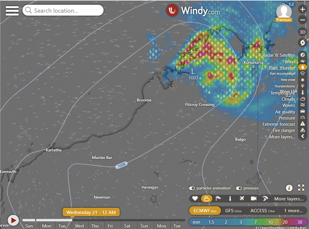
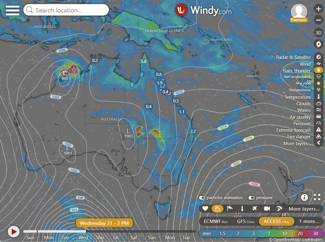
Ex TC Lincoln has moved West to the WA border and should keep going until it reaches the coast near Broome. It should then head a little out to sea and move more SW. There is the chance it could reform, but one day at a time for now. We are probably watching the monsoon head into reverse as we see the pulse move back to the West over the next week or two. For more detail check out this blog on the movement of the monsoon currently.


National
Rain, storms, and showers across the tropics, heaviest in the northwest due to ex Tropical Cyclone Lincoln. Showers and storms in Tas, Qld, NSW, and Vic due to humid, unstable onshore airflow. High-pressure system keeping elsewhere largely dry.


Synoptic | Temp/Rain | Wind | Sea Surface Temp
State
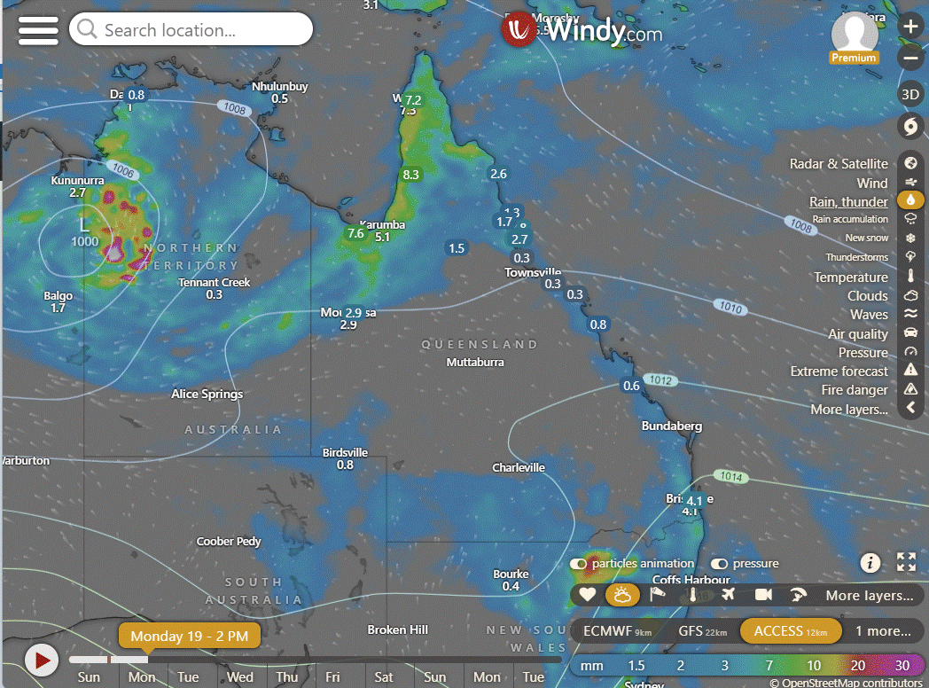
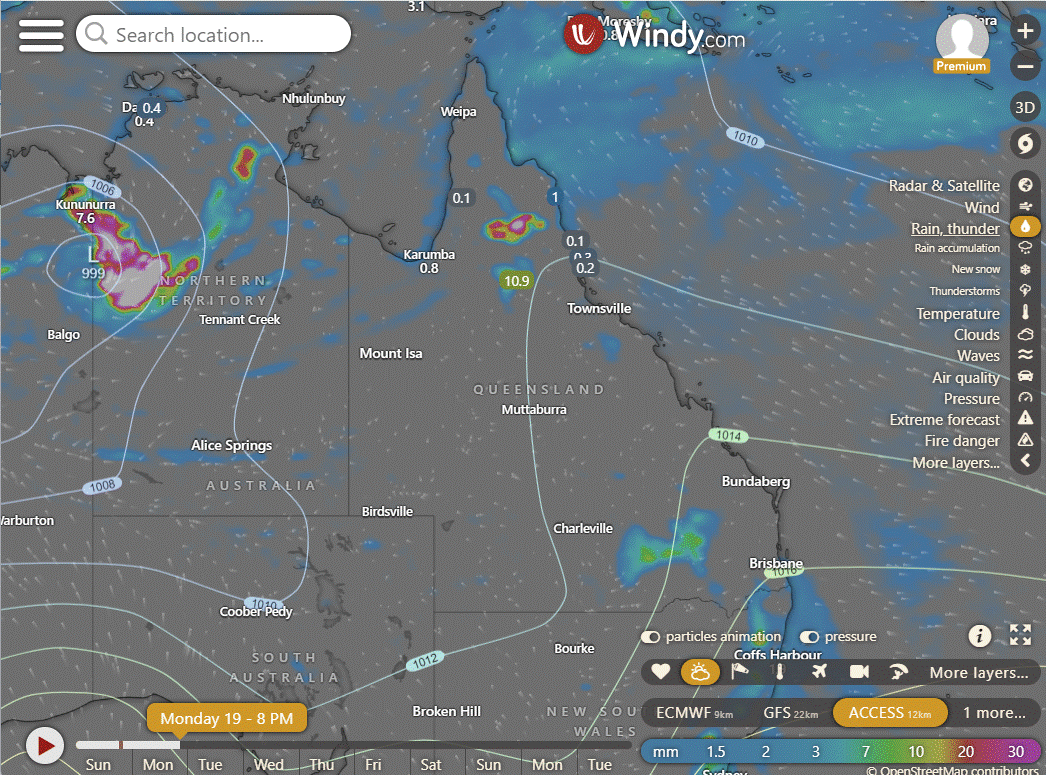
Active monsoon trough moving north, Ex-Tropical Cyclone Lincoln weakening over NT, ridge strengthening over eastern Queensland, showers and storms in southeast, another trough moving across southwestern Queensland.


ACCESS (Values are rainfall over 3 hours)
4-day
Monday: Sunday's weather: Isolated thunderstorms and showers in northern Queensland. Widespread at times for Peninsula, Gulf Country, North Tropical Coast with heavy rainfall possible. Isolated showers south of Townsville, scattered on Central Coast. Isolated showers, possible thunderstorm in southern Queensland west of Stanthorpe. Partly cloudy in central and southern interior. Light to moderate northeast/easterly winds, fresh at times on central coast.
Tuesday: Varied wet weather in different regions, with potential thunderstorms. Temperatures mostly below average.
Wednesday: Varied showers and storms across regions with temperatures below average in northwest.
Thursday: There will be scattered showers and isolated thunderstorms in various parts of Queensland, with temperatures below average in the northwest and above average in central and southern areas.


North Tropical Coast and Tablelands:
Max temperature: around 30, Min temperature: 20-25, Wind speed: Light becoming 15-25 km/h, Wind direction: East to southeasterly, Rainfall: Medium chance of showers, Thunderstorm possible.
Herbert and Lower Burdekin:
Max temperature: low 30s, Min temperature: low to mid 20s, Wind speed: Light becoming northeast to southeasterly 15 to 20 km/h, Wind direction: northeast to southeasterly, Rainfall: Slight chance of a shower, Other: Partly cloudy.
Central Coast and Whitsundays:
Max temperature: around 30, Min temperature: low 20s, Wind speed: southeasterly 15 to 25 km/h becoming light, Wind direction: southeasterly tending easterly, Rainfall: medium chance of showers, Other: Partly cloudy with temperatures falling in the late evening.
Peninsula:
The forecast for today includes a maximum temperature in the low 30s, minimum temperature in the low to mid 20s, light winds, overcast skies with a very high chance of showers, potential thunderstorms, and overnight temperatures dropping to the low to mid 20s.
Gulf Country:
Max temperature: low 30s, Min temperature: low to mid 20s, Wind speed: light, Wind direction: not specified, Rainfall: high chance of showers, Other: Cloudy with chance of thunderstorm.
Northern Goldfields and Upper Flinders:
Low temperatures will fall to the low 20s with daytime temperatures ranging from low to mid 30s, with light winds becoming easterly at 15 to 20 km/h and a chance of showers, thunderstorms and partly cloudy skies.
Capricornia:
Max temperature: low 30s, Min temperature: between 18 and 22, Wind speed: 15 to 20 km/h, Wind direction: southeasterly turning easterly, Rainfall: Medium chance near coast, slight elsewhere, Other: Partly cloudy.
Central Highlands and Coalfields:
Maximum temperature: low to mid 30s; Minimum temperature: 18-21; Wind speed: light, becoming east to southeasterly 15-20 km/h, then light; Wind direction: east to southeasterly; Rainfall: slight chance of a shower near Carnarvon Ranges, near zero elsewhere; Other: Mostly sunny, chance of thunderstorm in the south from late morning.
Central West:
Mostly sunny with low to high 30s temperatures, light winds becoming easterly 15 to 20 km/h, and overnight temperatures falling to the low 20s.
North West:
Partly cloudy with high chance of showers in northwest, slight chance elsewhere. Chance of a thunderstorm. Light winds becoming easterly 15-20 km/h, with max temp 37°C, min temp 20°C, and rainfall expected throughout.
Channel Country:
Max temperature: Around 40°C, Min temperature: Mid to high 20s, Wind speed: Light becoming 15-20 km/h, Wind direction: North to northeasterly, Rainfall: Slight chance in southeast, Thunderstorm: Chance in late morning and afternoon. Sunny elsewhere.
Maranoa and Warrego:
Partly cloudy with max temperature of 38, min temperature of 19, light winds, and chance of showers and thunderstorms.
Darling Downs and Granite Belt:
Max temperature: 30°C, Min temperature: 17-22°C, Wind: Light becoming NE 15-20 km/h, Rain: High chance of showers, Thunderstorm likely.
Wide Bay and Burnett:
Max temperature: 30°C, Min temperature: 17-21°C, Wind: Light winds becoming easterly 15-20 km/h, Rainfall: Medium chance of showers, Sky: Partly cloudy with chance of thunderstorm.
Southeast Coast:
The temperature will range from 18 to 30 degrees Celsius with light winds, partly cloudy skies, very high chance of showers and possible thunderstorms.
WEATHER WARNINGS
Severe Thunderstorm Warning (Heavy Rain & Hail) for Hunter, Central Tablelands, S Tablelands, CW Slopes & Plains, South Coast & Snowy Mountains.
Strong Wind Warning for Leeuwin Coast.
Fire Weather Warning for MidW Cst, Midwest Inland, Lesueur, Yarra Yarra, Swan Cstal North, Swan Inland North, Swan Inland South, Capes, Brockman.
Severe Weather Warning (Heavy, Locally Intense Rainfall And Damaging Winds) for parts of Gregory, Barkly, and Tanami districts.
Minor Flood Warning For The Tully River.
Strong Wind Warning for Central North, Lower East, South East, and South West coasts.
Minor Flood Warning For The Bulloo River.
Minor Flood Warning For The Paroo River (Qld).
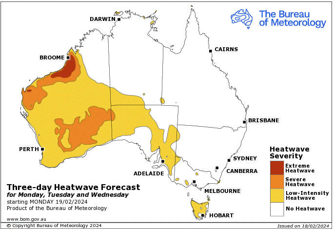
Heatwave Warning for Western Australia (repeated several times).
Major Flood Warning For The Nicholson River.
Flood Watch For East, West And North Kimberley And Fitzroy Rivers And Sturt Creek District.
Major Flood Warning For The Flinders River.
Final Flood Warning For The Stanley River.
Flood Watch For Parts Of Bonaparte Coastal Rivers, Carpentaria Coastal Rivers, Central Inland Rivers And Kimberley.
Severe Weather Warning (Heavy, Locally Intense Rainfall And Damaging Winds) for parts of Kimberley district.
Major Flood Warning For The Diamantina River.
Flood Watch For Gulf Of Carpentaria Catchments.
Moderate Flood Warning For The Daly River.
Moderate Flood Warning For Eyre Creek And Minor Flood Warning For The Georgina River.
Minor Flood Warning For The Mary River.
Fire Weather Warning for Eastern Eyre Peninsula.
Moderate Flood Warning For The Barcoo River And Minor Flood Warning For Cooper Creek.
Minor Flood Warning For The Dawson And Isaac Rivers And Flood Warning For The Comet River.
Minor Flood Warning For The Balonne River Minor And Bokhara River.
Minor Flood Warning For The Moonie River.
Flood Warning For The Inland Rivers Sa.
Minor Flood Warning For The Paroo River (Nsw).
Minor Flood Warning For The Lower Warrego River (Qld).

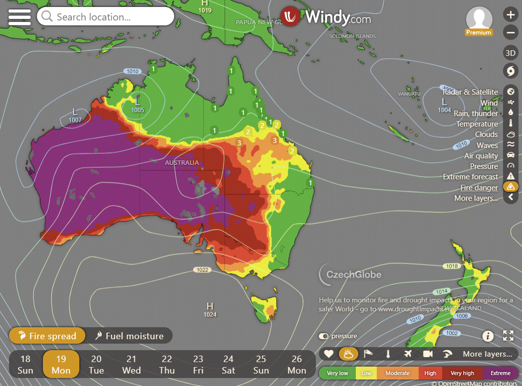
Storms - Heatwave - Fire danger
Click here to support to Wally's Weather
National maps by Weatherzone (weatherzone.com.au)
State maps by Windy (Windy.com)
Weather forecast supplemented by Bureau of Meteorology (bom.gov.au)
Rainfall daily totals (https://meteologix.com/ )
AccuWeather (https://www.accuweather.com/)
Nine Weather (https://www.9news.com.au/weather)
Wally's Weather provides professionally researched data and information. Andrew aka 'Wally' has over 20 years of experience in meteorology research and data analysis. In 2023 finished top 4 for the AMOS national weather forecasting competition. The content here is provided as educational information aimed at providing the community and businesses with the tools required to determine local-based forecasts. IMPORTANT: The forecasts and information posted should never be used on their own to make business decisions as local influences.


Comments