Morning Weather - January 20 - Wally's Weather Australia
- Jan 19, 2024
- 6 min read
This weather update is brought to you by Genesis Electrical NQ

Genesis Electrical NQ
We can Solve all of your Electrical, Air Conditioning and Solar needs!
Phone: 1300 443 637
Email: info@genesislec.com
Monsoon update
The weather system called INVEST 90P, previously near 14.5S 154.8E, is now around 14.2S 157.0E, approximately 1,250 kilometers east-northeast of Cairns, Australia. Satellite images show a developing low-pressure center with bands of clouds wrapping around it. The conditions for growth are somewhat favorable, with good air circulation, moderate to high wind speeds (20-25 knots), and warm sea temperatures (29-30°C). Global models predict that INVEST 90P will move slowly southwest and gradually strengthen over the next 24-48 hours. Currently, it has sustained winds of 25 to 30 knots, with a minimum central pressure of about 999 hPa. There is a medium chance that it could become a significant tropical cyclone in the next 24 hours.
Four days from now the EC has the low very slowly moving, the GFS has moved South a little more and ACCESS has begun to move back towards the coast. But still enough difference. More than likely a cyclone by now. My forecast in the comp (but my guess doesn't count was the 22nd for a start)


ACCESS | GFS | EC
National
Monsoon trough and lows will bring heavy rain and storms to northern tropics. A broad trough may bring showers and storms to NT's interior, QLD, and northeast NSW.
Building heat in the interior and SA. Tropical low deepening over the Coral Sea.


Synoptic | Temp/Rain | Wind | Sea Surface Temp
State
The monsoon trough is present in the southern Gulf of Carpentaria coast, Cape York Peninsula, and the Coral Sea for several days. A weak tropical low is currently located on the monsoon trough in the northern Coral Sea, east of Cairns, and will eventually move east. It has the potential to become a tropical cyclone by late Sunday or early next week, heading southwest towards the Queensland coast. However, there is uncertainty regarding its future movements and the possibility of it crossing the coast. Meanwhile, a trough over southeastern inland Queensland will weaken over the weekend and shift slightly westward as a weak ridge forms along the east coast.


ACCESS 3Hour Rainfall
4-day
Saturday: Rain in far north/northwest, showers/thunderstorms in other areas, severe storms with heavy rain possible in various regions. Moderate winds, stronger in north/northwest.
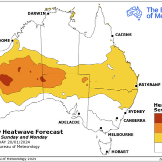
Sunday: Sunday: Showers and thunderstorms in the northwest and Far North. Isolated showers in eastern districts, becoming scattered on the Central Coast. Showers and thunderstorms in the interior. Below average temperatures in the northwest, above average elsewhere. Heatwave conditions developing in eastern and southern Queensland, severe in the interior and humid in the South East.
Monday: Scattered showers and thunderstorms in northwest and Far North, more isolated south of Port Douglas. Widespread showers over Peninsula district. Isolated showers and possible thunderstorm in southeast. Isolated showers and thunderstorms in far western Queensland, partly cloudy in southern interior. Chance of severe thunderstorms in South East Queensland. Below average temperatures in northwest, above average elsewhere, especially in the south. Heatwave conditions in eastern, central, and southern districts, locally severe in southwest and southern interior, with humid conditions in southeast Queensland.
Tuesday: Scattered showers in the northwest and Far North will become widespread over the northern Peninsula, with isolated showers south of Cooktown. Eastern districts south of Ingham will have isolated showers, becoming scattered near the southeast coast. Far western Queensland will experience isolated showers and thunderstorms, while the southern interior will be partly cloudy. Southeasterly winds may develop along the east coast south of Townsville. Maximum temperatures will be near or below average in the northwest but well above average in the southwest and southern interior. Heatwave conditions, locally severe in the southwest and southern interior, will occur in central and southern districts, but the South East will have less humid conditions.


North Tropical Coast and Tablelands:
Max temperature: 30; Min temperature: low to mid 20s; Wind speed: Light; Wind direction: N/A; Rainfall: Very high chance of rain, mostly from late morning; Other: Cloudy, chance of severe thunderstorm.
Herbert and Lower Burdekin:
Max temperature: 29 to 34, Min temperature: low to mid 20s, Wind speed: light to 25 km/h, Wind direction: northeasterly, Rainfall: Partly cloudy with high chance of showers in the north, medium chance elsewhere, Chance of thunderstorm.
Central Coast and Whitsundays:
Max temperature: 31 to 36, Min temperature: low to mid 20s, Wind speed: light, Wind direction: becoming easterly, Rainfall: slight chance of a shower, Other: Partly cloudy, chance of thunderstorm in the south, winds light in the late evening.
Peninsula:
Max temperature: low 30s, Min temperature: mid 20s, Wind speed: light to 25 km/h, Wind direction: north to northwesterly, Rainfall: very high chance of showers, Thunderstorm: possible and severe, Other: Cloudy.
Gulf Country:
Max temperature: low 30s, Min temperature: mid 20s, Wind speed: 15 to 25 km/h, Wind direction: northeasterly, Rainfall: Showers likely, Cloudy with a thunderstorm possible, possibly severe.
Northern Goldfields and Upper Flinders:
Max temperature: 30 to 35, Min temperature: low to mid 20s, Wind speed: northeasterly 15 to 20 km/h becoming light before dawn then becoming northeasterly 15 to 25 km/h in the morning, Wind direction: northeasterly, Rainfall: High chance of showers, most likely in the late morning and afternoon. The chance of a thunderstorm, possibly severe. Other: Cloudy.
Capricornia:
Max temperature: low to mid 30s, Min temperature: low to mid 20s, Wind speed: light becoming 15 to 20 km/h, Wind direction: east to northeasterly, Rainfall: medium chance of showers in the afternoon and evening, with chance of thunderstorm, Other: Partly cloudy.
Central Highlands and Coalfields:
Max temperature: low to mid 30s, min temperature: low to mid 20s, wind speed: light becoming east to northeasterly 15 to 20 km/h, wind direction: east to northeasterly, rainfall: high chance of showers, partly cloudy, with a chance of severe thunderstorms and heavy rain in Carnarvon Ranges, possible flash flooding.
Central West:
Max temperature: mid to high 30s, Min temperature: low to mid 20s, Wind speed: 15 to 25 km/h (east to northeasterly), Rainfall: High chance of showers, Thunderstorm possibility: Yes (possibly severe with heavy rain), Flash flooding: Possible in the southeast, Cloud cover: Partly cloudy.
North West:
Max temperature: mid 30s, Min temperature: low to mid 20s, Wind speed: 15 to 25 km/h from E-NE, Rainfall: high chance of showers, Wind direction: E-NE, Other: Partly cloudy, chance of thunderstorm.
Channel Country:
The weather will have a maximum temperature of 36 to 41 degrees Celsius, a minimum temperature in the mid to high 20s, east to northeasterly winds of 15 to 25 km/h, a chance of showers, and a chance of a severe thunderstorm.
Maranoa and Warrego:
Max temperature: 32 to 38, Min temperature: low to mid 20s, Wind speed: light, Wind direction: N/A, Rainfall: Partly cloudy. Medium chance of showers in the north, slight chance elsewhere. The chance of a thunderstorm, possibly severe with heavy rain which may lead to flash flooding in the north.
Darling Downs and Granite Belt:
Max temperature: 30-35 | Min temperature: low to mid 20s | Wind speed: light | Wind direction: northeasterly | Rainfall: medium chance of showers | Other: Partly cloudy, chance of thunderstorm, light winds in the evening.
Wide Bay and Burnett:
Max temperature: 30, min temperature: low to mid 20s, wind speed: light, wind direction: easterly, rainfall: high chance of showers, other: partly cloudy with chance of thunderstorm.
Southeast Coast:
Max temperature: 30, Min temperature: low 20s, Wind speed: light to 20 km/h, Wind direction: southeasterly becoming easterly, Rainfall: high chance of showers becoming less likely in the evening, Other: chance of severe thunderstorm with heavy falls along the coastal fringe in the early morning.
WEATHER WARNINGS
Severe Thunderstorm Warning for parts of Southeast Queensland (Heavy Rainfall).
Severe Storm Warning (Rain) for various regions in Queensland.
Strong Wind Warning for Ningaloo and Gascoyne coasts.
Severe Weather Warning (Heavy, Locally Intense Rainfall) for Carpentaria, Gregory, Barkly, and Tanami districts.
Fire Weather Warning for Ashburton Coast.
Strong Wind Warning for various coasts in the Northern Territory.
Ocean Wind Warning for Tropical Cyclone.
Minor Flood Warning for the Katherine River.
Strong Wind Warning for Gulf of Carpentaria coasts.
Minor Flood Warning for the Warrill Creek Catchment.
Strong Wind Warning for Central Gippsland and East Gippsland coasts.
Strong Wind Warning for Saturday for Spencer Gulf.
Initial Flood Watch for East and West Kimberley and Fitzroy Rivers and Sturt Creek District.
Final Flood Warning for the Barron River.
Fire Weather Warning for Eastern Eyre Peninsula, Mid North, Murraylands, and Upper South East.
Strong Wind Warning for various coasts, including Fred Hen Bay & Norfolks, Storm Bay & Upper East, Lower E & South E Coasts.
Strong Wind Warning for Eden Coast.
Minor Flood Warning for the Murray River.
Heatwave Warnings for Western Australia, Northern Territory, Queensland, and South Australia.
Various flood warnings and watches for rivers in different regions.


Storms - Heatwave - Fire danger
Click here to support to Wally's Weather
National maps by Weatherzone (weatherzone.com.au)
State maps by Windy (Windy.com)
Weather forecast supplemented by Bureau of Meteorology (bom.gov.au)
Rainfall daily totals (https://meteologix.com/ )
AccuWeather (https://www.accuweather.com/)
Nine Weather (https://www.9news.com.au/weather)
Wally's Weather provides professionally researched data and information. Andrew aka 'Wally' has over 20 years of experience in meteorology research and data analysis. In 2023 finished top 4 for the AMOS national weather forecasting competition. The content here is provided as educational information aimed at providing the community and businesses with the tools required to determine local-based forecasts. IMPORTANT: The forecasts and information posted should never be used on their own to make business decisions as local influences.


Comments