Morning Weather - January 25 - Wally's Weather Australia
- Jan 24, 2024
- 7 min read
This weather update is brought to you by Genesis Electrical NQ

Genesis Electrical NQ
We can Solve all of your Electrical, Air Conditioning and Solar needs!
Phone: 1300 443 637
Email: info@genesislec.com
Monsoon update
Initial Position: 17.4°S 152.2°E
Initial Intensity: 45 knots (Approximately 83.34 km/h)
Geographic Reference: 368 nautical miles (Approximately 681.776 km) east of Cairns, Australia
Movement Past 6 Hours: Westward at 6 knots (Approximately 11.12 km/h)
Significant Wave Height: 19 feet (Approximately 5.79 meters)
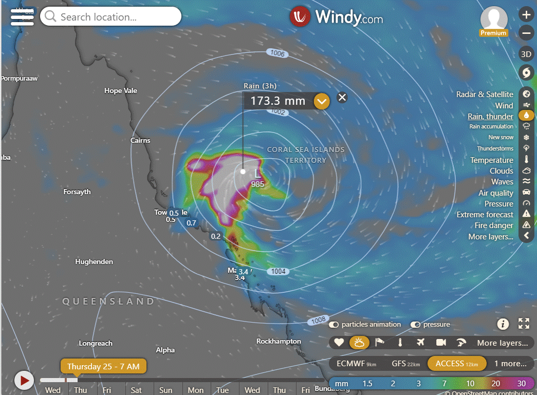
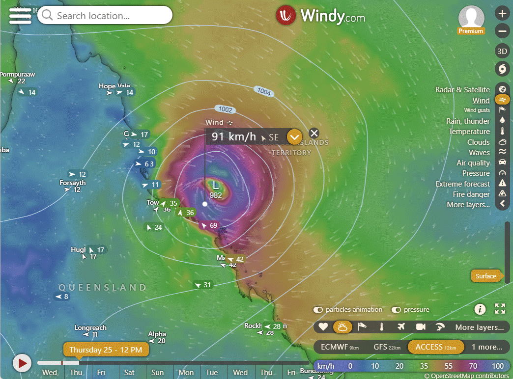
Conditions in the upper atmosphere have improved recently, showing a clear center and strong outward airflow. Satellite images indicate increased thunderstorm activity around the center, especially on the west side. Microwave imagery confirms these storm bands wrapping around a more organised center. The storm is currently passing over Lihou Reef, experiencing light north winds after a period of southerly winds. The lowest air pressure recorded is 991.8 hPa. The storm's position is determined with moderate confidence based on various satellite images and surface observations. The storm's strength, estimated at 45 knots, is also moderately confident based on different analyses.
ACCESS | GFS | EC
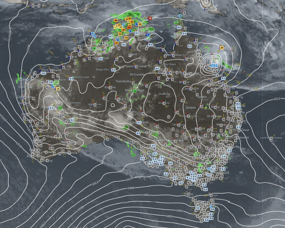
National
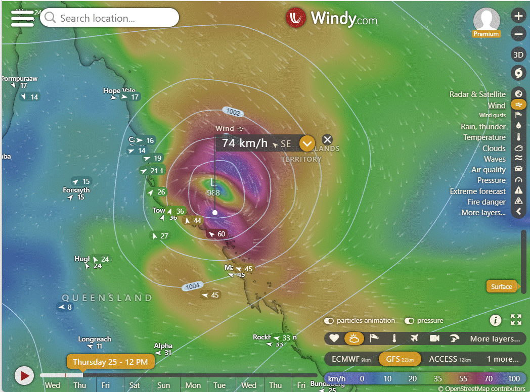
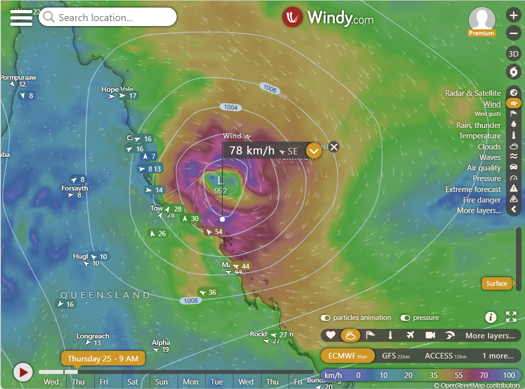
Tropical cyclone Kirrily expected to make landfall on the QLD coast as a severe system. Troughs affecting the west, tropics, and interior, bringing showers and storms to WA, NT, and SA. A front and trough causing gusty showers in Vic, Tas, and southeast NSW, while directing heat east.

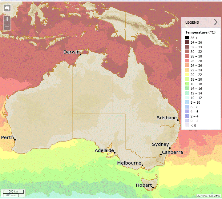
Synoptic | Temp/Rain | Wind | Sea Surface Temp
State
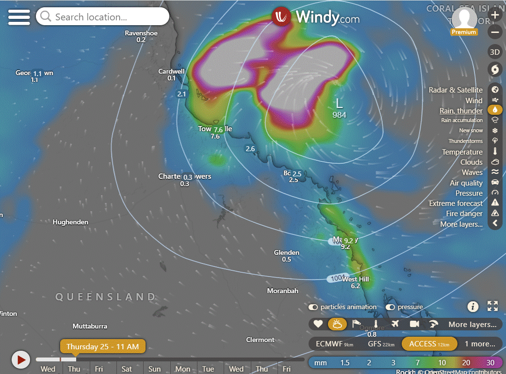
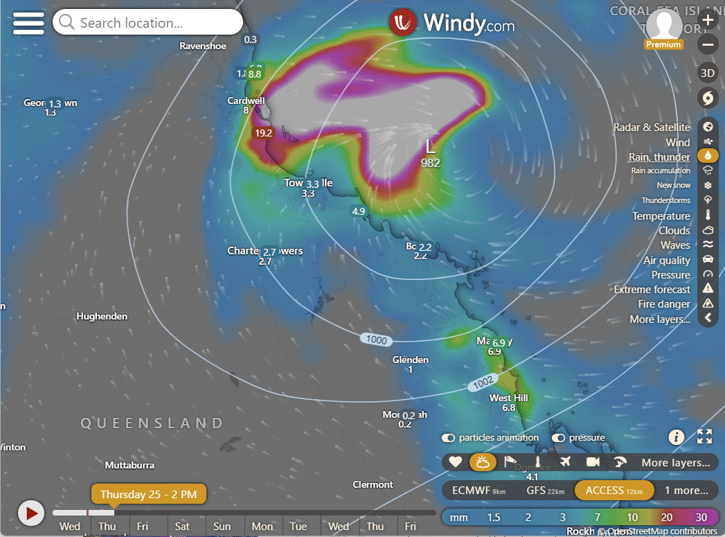
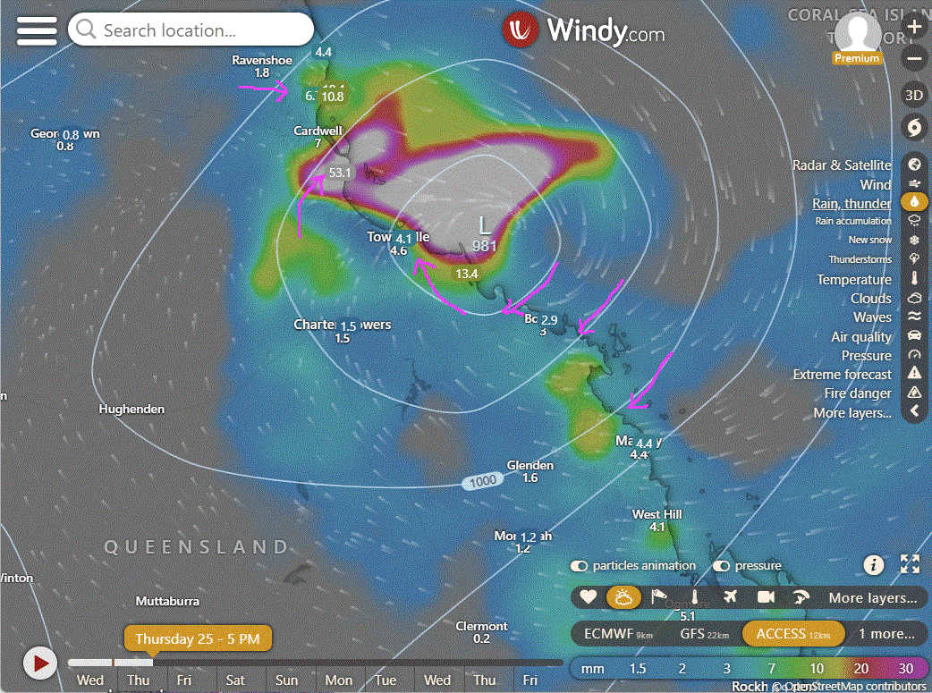
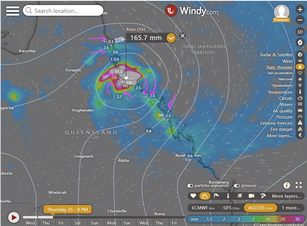
Looking closely at the expected impact region, the wind once peaking has been shown with pink arrows so you know which direction the wind should come from. From the bottom is from the South, From the right is from the East, From the left is from the West and from the top is from the North. Note Townsville will get it's winds from the SW and W based on these models. That would change if the cyclone crossed further North or South.
Equatorial trough to persist, tropical low becomes cyclone, tracks towards Queensland coast, brings rain and flooding. Trough enhances showers in southeast Queensland. Ridge follows trough.
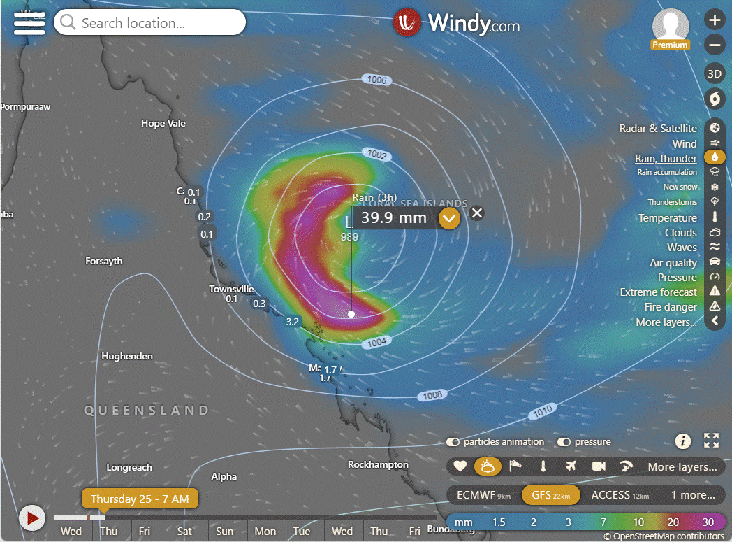
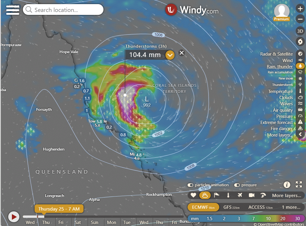
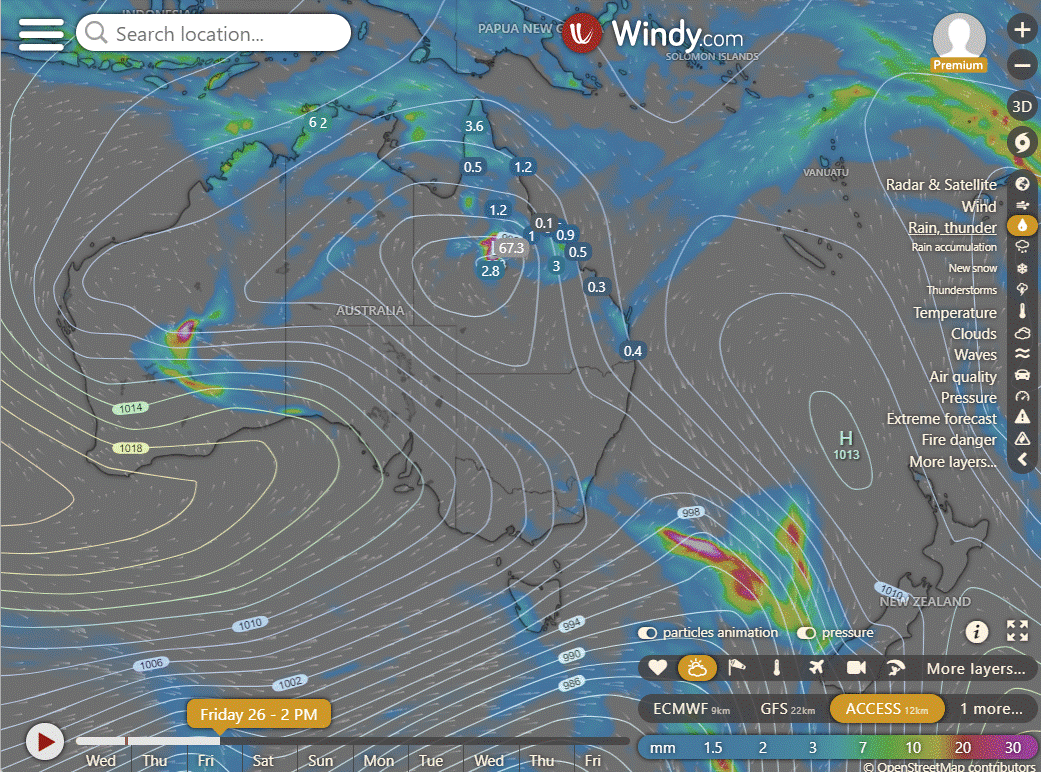
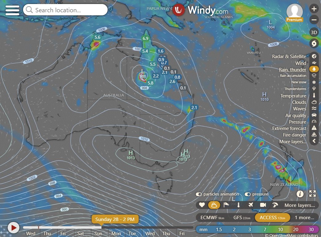
ACCESS 3Hour Rainfall
4-day
Thursday: Isolated showers and thunderstorms in some areas, becoming scattered to widespread in the northern Peninsula. Isolated showers in the east, becoming scattered between Townsville and Whitsundays later. Heavy rain may occur overnight on the east coast south of Ingham. Severe thunderstorm with damaging winds possible in the Gulf Country. Clear in the central and southern interior. Strong to gale winds developing on the Central Coast and Islands later tonight.
Friday: Isolated showers and thunderstorms across most of the state, with scattered showers in northern, central, and eastern Queensland. Widespread showers and areas of rain in the central east and northeast, with a risk of heavy falls that may cause flash flooding. Possible damaging winds along the tropical east coast and inland. Temperatures near or above average, but below average in the central to northern interior. Heatwave conditions in parts of the west and interior, possibly developing in the tropical northeast coast.
Saturday: Scattered showers and isolated thunderstorms in eastern, northern, and central Queensland, becoming more widespread. Heavy rainfall may cause flash flooding in central and northern interior districts and possibly extend to the northwest. A risk of heavy falls and severe thunderstorms near the NSW border. Windy in coastal areas south of Ingham. Temperatures near or above average but cooler in central and northern interior districts. Heatwave conditions easing in the southwest but persist in parts of the tropical northeast coast.
Sunday: Scattered showers and isolated thunderstorms across eastern, northern, and central Queensland. Rain becoming widespread in the northern and central interior. Showers occasionally in South East Queensland. Possible heavy rainfall in the northwest, central, and northern interior due to Ex-tropical cyclone Kirrily. Severe thunderstorms with heavy rainfall possible in southeastern Queensland. Above-average temperatures in the east and Gulf Districts, but near or below average in the interior and west. Heatwave conditions in parts of the tropical northeast coast.


North Tropical Coast and Tablelands:
Max temperature: 31, Min temperature: low to mid 20s, Wind speed: damaging wind gusts exceeding 90 km/h, Wind direction: N/A, Rainfall: high chance of rain, partly cloudy, with heavy falls possible inland, Other: chance of severe thunderstorm and Tropical Cyclone Kirrily’s movement and development affecting conditions.
Herbert and Lower Burdekin:
Max temperature: 31°C, Min temperature: low to mid 20s, Wind speed: ?, Wind direction: ?, Rainfall: Cloudy. Very high chance of rain, most likely from the late morning. The chance of a thunderstorm, possibly severe. Heavy falls possible. Destructive wind gusts exceeding 130 km/h possible depending on movement and development of Tropical Cyclone Kirrily.
Central Coast and Whitsundays:
Max temperature: 31, Min temperature: low to mid 20s, Wind speed: Very high, Wind direction: variable, Rainfall: showers, Other: Cloudy, Chance of thunderstorm and destructive wind gusts depending on Tropical Cyclone Kirrily.
Peninsula:
Max temperature: 35, Min temperature: low 20s, Wind speed: 15-20 km/h to 25-35 km/h, Wind direction: north to northwesterly to west to northwesterly, Rainfall: Partly cloudy with high chance of showers north of Weipa and medium chance elsewhere, Thunderstorm likely, Overnight temperatures falling to low to mid 20s with daytime temperatures reaching 29 to 35.
Gulf Country:
Max temperature: 39, Min temperature: mid to high 20s, Wind speed: 20 to 30 km/h, Wind direction: NW to SW, Rainfall: Partly cloudy, Medium chance of showers in the east, slight chance elsewhere, Chance of a thunderstorm.
Northern Goldfields and Upper Flinders:
Max temperature: 42, Min temperature: low to high 20s, Wind speed: damaging wind gusts exceeding 90 km/h, Wind direction: depending on movement and development of Tropical Cyclone Kirrily, Rainfall: heavy falls possible in the east, Other: Partly cloudy with very high chance of rain, high chance elsewhere, chance of severe thunderstorm in the afternoon and evening.
Capricornia:
Max temperature: Low to mid 30s, Min temperature: 20 to 26, Wind speed: 30 to 45 km/h southeasterly turning to 35 to 50 km/h easterly, Rainfall: High chance of showers in the north, medium chance elsewhere, Other: Partly cloudy, chance of a thunderstorm.
Central Highlands and Coalfields:
Max temperature: 37, Min temperature: low to mid 20s, Wind speed: 40 to 60 km/h, Wind direction: east to southeast, Rainfall: near zero chance, Other: Partly cloudy with medium chance of showers, chance of thunderstorm.
Central West:
Max temp: 44°C, Min temp: 24-29°C, Wind speed: 30-45 km/h, Wind direction: East to Southeasterly, Rainfall: Near zero chance, Other: Mostly sunny, slight chance of shower in northeast, chance of thunderstorm in afternoon/evening.
North West:
Max temperature: 39 to 45, Min temperature: around 30, Wind speed: 15 to 25 km/h, Wind direction: northwest to southwesterly, Rainfall: Partly cloudy with showers likely north of Mt Isa, slight chance elsewhere, Thunderstorm possible in the afternoon and evening.
Channel Country:
The forecast predicts a sunny morning, with a chance of thunderstorms near the Northern Territory border in the afternoon and evening, and temperatures ranging from low 30s overnight to 43-49 degrees during the day, with winds changing direction and speed throughout the day.
Maranoa and Warrego:
Max temperature: 44, Min temperature: 22, Wind speed: 20-30 km/h from northeast, Rainfall: None, Other: Sunny
Darling Downs and Granite Belt:
The forecast includes max temp of 35 to 41, min temp of 17 to 23, wind of 20 to 30 km/h from the northeast, rainfall, and sunny conditions.
Wide Bay and Burnett:
Max temperature: 31 to 36 | Min temperature: 18 to 23 | Wind speed: 15 to 20 km/h, later increasing to 20 to 30 km/h | Wind direction: East to southeasterly, later tending east to northeasterly | Rainfall: Slight chance of a shower in the north in the evening, near-zero chance elsewhere | Other conditions: Partly cloudy with chance of thunderstorm in the north.
Southeast Coast:
Max temperature: low to mid 30s, min temperature: 17-22, wind speed: light becoming northeasterly 15-20 km/h, wind direction: northeasterly, rainfall: none, other: mostly sunny.
WEATHER WARNINGS
Severe Thunderstorm Warning (Heavy Rainfall) for parts of Daly, Arnhem, and Carpentaria districts.
Tropical Cyclone Advice for Queensland.
Strong Wind Warning for Banks Strait & Franklin Sound, East of Flinders Is & CN, SE & SW coasts. (Cancelled for Far NW, Upper East & Lower E Coasts).
Severe Weather Warning (Heavy Rainfall) for parts of Pilbara, Gascoyne, Goldfields, Eucla, and South Interior districts.
Strong Wind Warning for Pilbara Coast West, Perth Local Waters & Ningaloo, Gascoyne, Geraldton, Lancelin, Perth & Bunbury Geographe coasts.
Fire Weather Warning for Swan Inland North.
Severe Thunderstorm Warning (Damaging Winds) for parts of North West Pastoral district.
Gale Warning Great Barrier Rf Offshore Waters & Townsville & Mackay coasts. (Strong Wind Warning for Capricornia Coast. Cancelled Cairns Coast).
Strong Wind Warning for Thursday for Arafura and Gove Peninsula coasts.
Strong Wind Warning for Central Gippsland and East Gippsland coasts. (Cancelled for Central Coast).
Strong Wind Warning for Thursday for Spencer Gulf.
Strong Wind Warning for Hunter, Sydney, Illawarra, Batemans, and Eden coasts.
Final Flood Warning For The Murray River.
Moderate Flood Warning For The Paroo River (Qld).
Minor Flood Warning For Cooper Creek.
Minor Flood Warning For The Bulloo River.
Flood Watch For Fitzroy River, Sandy Desert, De Grey River, Fortescue River, Ashburton River, Gascoyne River, & Salt Lakes District Rivers.
Flood Watch For The Cape York Peninsula And Parts Of The Gulf Country.
Flood Watch For Coastal And Adjacent Inland Catchments Between Tully And Airlie Beach, And Parts Of The Central West And Gulf Catchments.
Final Flood Watch For The North Western And Parts Of Central Nt.
Minor Flood Warning For The Paroo River (Nsw).
Moderate Flood Warning For The Daly River.
Flood Warning For The Diamantina River.
Minor Flood Warning For The Fitzroy River.
Minor Flood Warning For The Warrego River (Nsw).
Minor Flood Warning For The Herbert River.
Flood Warning For The Victoria River.
Final Flood Warning For The Moonie River.
Fire Weather Warning for Exmouth Gulf Coast.
Final Flood Warning For The Cloncurry River.
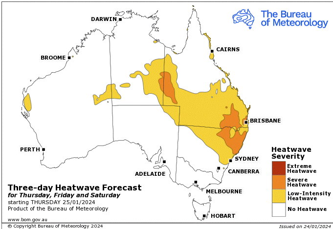
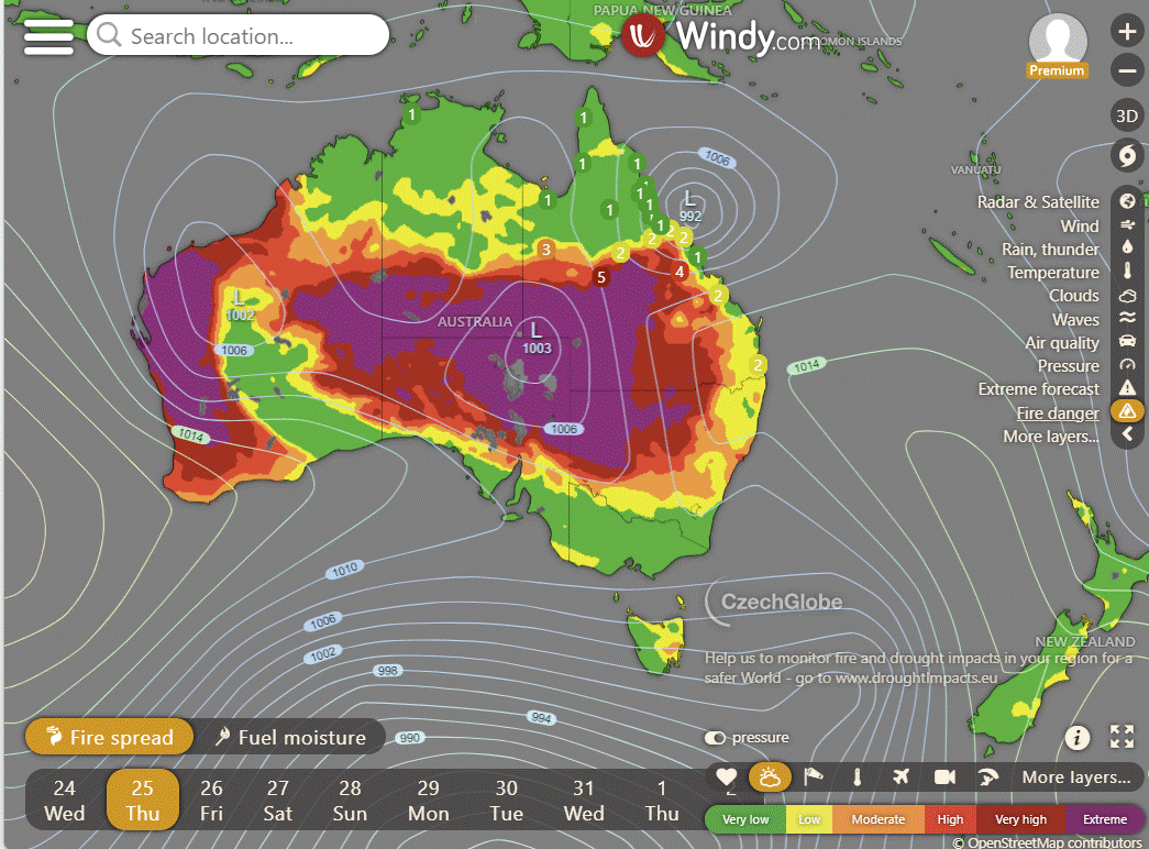
Storms - Heatwave - Fire danger
Click here to support to Wally's Weather
National maps by Weatherzone (weatherzone.com.au)
State maps by Windy (Windy.com)
Weather forecast supplemented by Bureau of Meteorology (bom.gov.au)
Rainfall daily totals (https://meteologix.com/ )
AccuWeather (https://www.accuweather.com/)
Nine Weather (https://www.9news.com.au/weather)
Wally's Weather provides professionally researched data and information. Andrew aka 'Wally' has over 20 years of experience in meteorology research and data analysis. In 2023 finished top 4 for the AMOS national weather forecasting competition. The content here is provided as educational information aimed at providing the community and businesses with the tools required to determine local-based forecasts. IMPORTANT: The forecasts and information posted should never be used on their own to make business decisions as local influences.


Thanks Wally from Saunders Beach