Morning Weather - January 29 - Wally's Weather Australia
- Jan 28, 2024
- 6 min read
This weather update is brought to you by Genesis Electrical NQ

Genesis Electrical NQ
We can Solve all of your Electrical, Air Conditioning and Solar needs!
Phone: 1300 443 637
Email: info@genesislec.com
Monsoon update
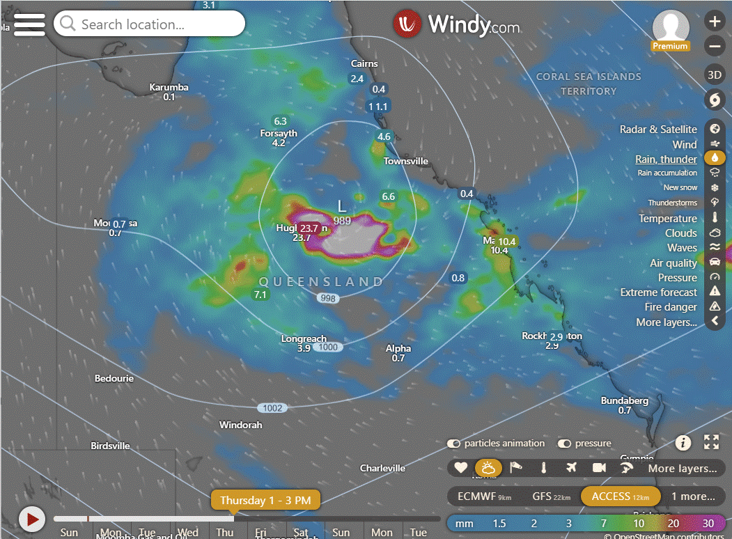
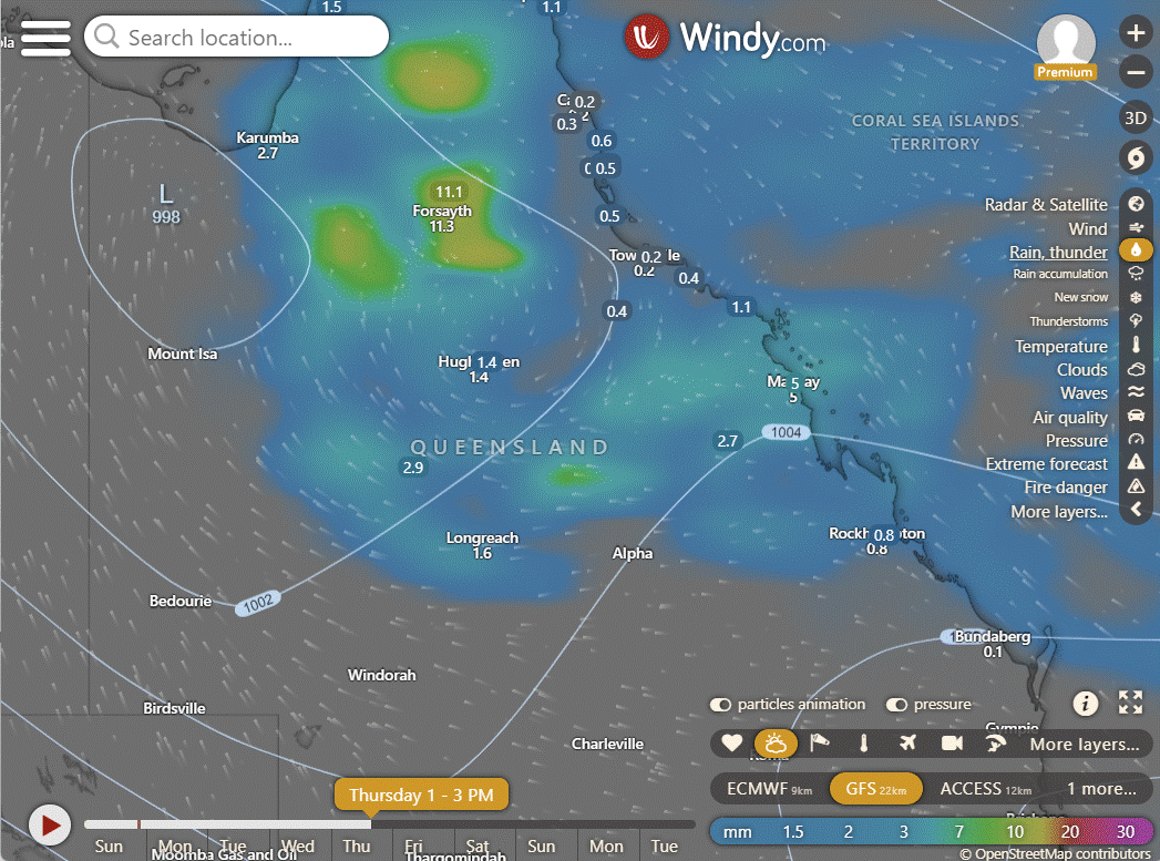
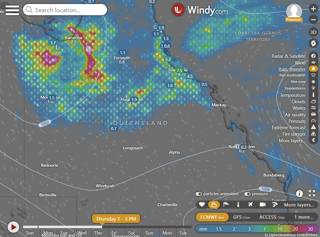
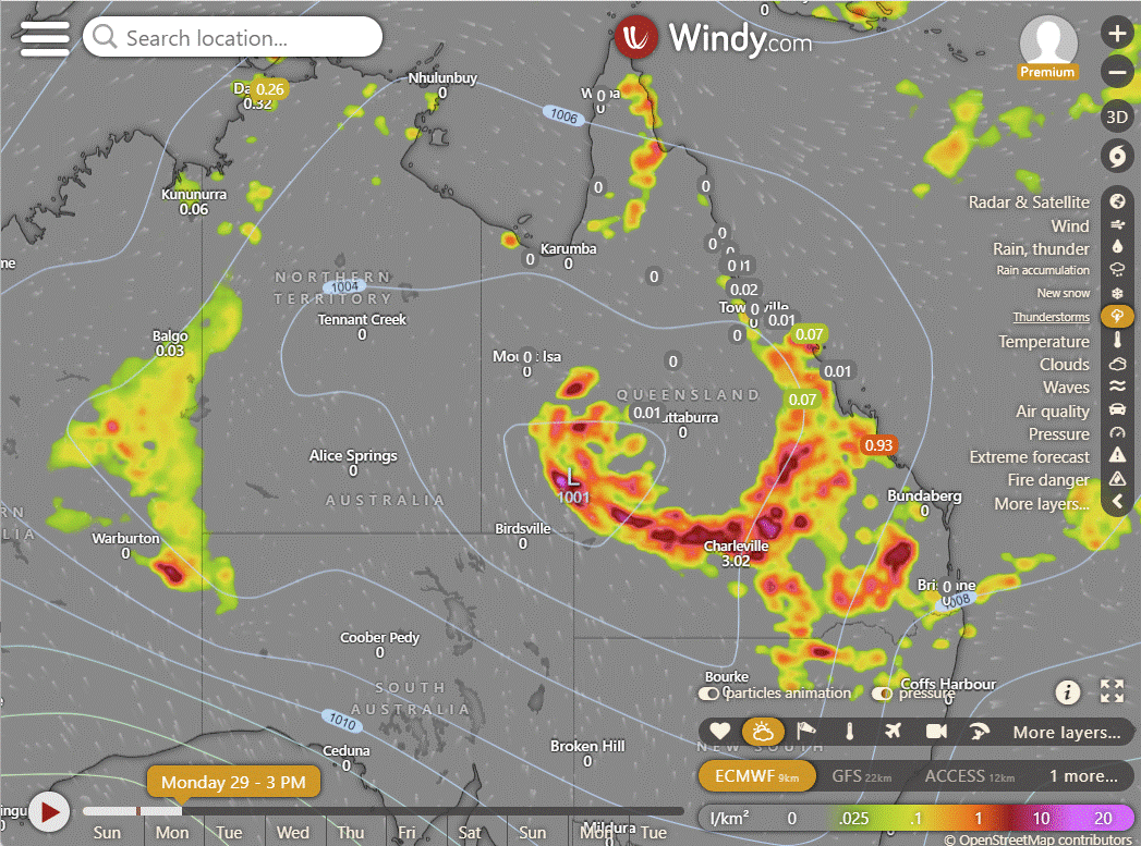
Ex TC Kirrily is still keeping everyone guessing. EC and GFS have it moving NW, ACCESS back East. Rain could be intensifying but only if this system moves East or near the Gulf coast. Still getting people saying they are seeing models of cyclones in the Coral Sea. No, there are none that are forecast and even tropical lows have no consistent forecasts. We do know that for the next week to two weeks the monsoonal activity is at its strongest over QLD and the Coral Sea. Tomorrow the low impacts from central QLD right through to the SE coast up to Bundy and Rocky. Ex TC Kirrily has impacted most of QLD.
The monsoon peak for our region was identified in August 2023, and that's in the PDF archive which you can access as a thank you to Big Shout supporters in the Long Range forecast .
ACCESS | GFS | EC
National
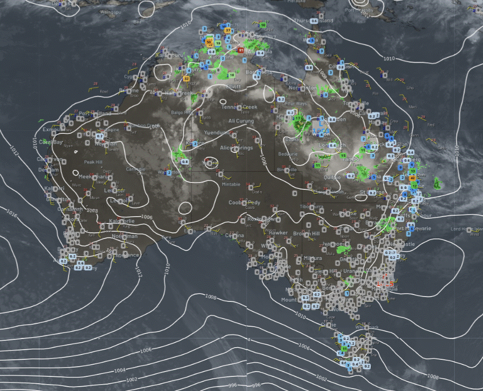
Troughs and lows generating rain, showers, and storms over:
WA's north & east.
The NT.
QLD.
NSW's northeast.
Onshore flow bringing a few showers to NSW's southeast. Clear conditions elsewhere due to a high-pressure ridge.
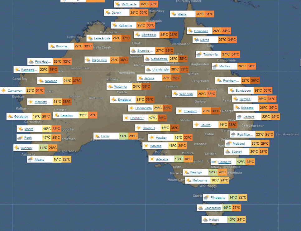
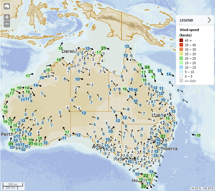
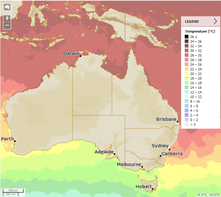
Synoptic | Temp/Rain | Wind | Sea Surface Temp
State
Ex-Tropical Cyclone Kirrily will linger across western Queensland, causing heavy rain and flooding. A trough will also remain over southeastern Queensland, creating unsettled conditions. These two systems will bring abundant moisture across the state. There might be a coastal trough or low forming near southeast Queensland, increasing rainfall. By Wednesday, a ridge will develop along the east coast and push the trough northwards towards central and northern Queensland.
ACCESS (Values are rainfall over 3 hours)
4-day
Monday: Scattered showers and thunderstorms in most areas, heavy rain and potential flash flooding in the northwest. Severe thunderstorms possible in central and southern Queensland. Partly cloudy in the far southwest. Light to moderate winds from the northwest to northeast, fresh in coastal areas. Light to moderate winds from the south to southeast in the far southwest.
Tuesday: Scattered showers, thunderstorms, and rain across most of the state. Possibility of heavy rainfall and flash flooding in the northwest near ex-Tropical Cyclone Kirrily. Potential for severe thunderstorms in southern and central Queensland. Temperatures vary across regions, with above-average temperatures along the east coast and far west, below-average in the central and southeastern interior, and near or slightly below average elsewhere. Humidity continues in eastern Queensland.
Wednesday: Scattered showers and thunderstorms across most of the state, with more widespread activity in central and coastal southeastern Queensland and the northern interior. Some severe thunderstorms and heavy rainfall possible in central and southeastern Queensland. Heavy rainfall also possible in western Queensland. Local heavy rain possible along South East and K'gari coasts. Fresh to strong southeasterly winds developing along the southeast coast. Above average temperatures in the tropical east coast and far west, near or below average elsewhere. Heatwave conditions in the northeast tropical coast and far west, becoming less humid in South East Queensland.
Thursday: Most of the state will have scattered showers and isolated thunderstorms, especially in the southeast. Northern and central Queensland may experience widespread showers and thunderstorms. There is a chance of heavy rainfall in western Queensland due to ex-Tropical Cyclone Kirrily. Severe thunderstorms with heavy rainfall are possible in central to northern Queensland. Maximum temperatures will be below average in the northwest, northern, and central interior, above average in the far southwest, and near or slightly above average elsewhere. The heatwave condition is decreasing along the northeast tropical coast but remains in parts of the far west.
North Tropical Coast and Tablelands:
Max temperature: 30 to 35, Min temperature: low to mid 20s, Wind speed: NW 15-20 km/h becoming light in the evening, Wind direction: NW, Rainfall: High chance of showers with a chance of a thunderstorm, Other: Partly cloudy.
Herbert and Lower Burdekin:
The day will have temperatures ranging from low to high 30s, with light winds, partly cloudy skies, a medium chance of showers from late morning, and the possibility of a thunderstorm.
Central Coast and Whitsundays:
Max temperature: low to mid 30s, Min temperature: mid to high 20s, Wind speed: light winds becoming north to northeasterly 15 to 20 km/h, Wind direction: variable, Rainfall: medium chance of showers and a thunderstorm, Other: Partly cloudy.
Peninsula:
The weather will be partly cloudy with high chance of showers and thunderstorms, with wind speeds ranging from 15 to 25 km/h, becoming light in the evening. Temperature will fall to the mid 20s overnight and reach the low to mid 30s during the day.
Gulf Country:
The max temperature is 38, the min temperature is mid to high 20s, wind speed is north to northwesterly 15 to 20 km/h, wind direction is northerly becoming light before dawn, chance of showers in the east, slight chance elsewhere, chance of a thunderstorm, and partly cloudy.
Northern Goldfields and Upper Flinders:
Max temperature: 31-37°C, Min temperature: low to mid 20s, Wind speed: 25-35km/h north to northwesterly, Wind direction: west to northwesterly, Rainfall: Partly cloudy, high chance of showers in the north, medium chance elsewhere, Thunderstorm chance: possible heavy falls in the southwest.
Capricornia:
Max temperature: low to mid 30s, Min temperature: mid to high 20s, Wind speed: light winds becoming northerly 15 to 20 km/h, Wind direction: northeasterly, Rainfall: partly cloudy with high chance of showers in the south and medium chance elsewhere, Other: chance of severe thunderstorm in the southwest.
Central Highlands and Coalfields:
The weather will be partly cloudy with showers likely, a chance of severe thunderstorm, light winds, and temperatures ranging from low to mid 20s overnight to 32-37 during the day.
Central West:
Max temperature: 31 to 36, Min temperature: low to mid 20s, Wind speed: 15 to 35 km/h, Wind direction: northeast to northeasterly, Rainfall: high chance of showers and possibly a thunderstorm, Partly cloudy.
North West:
Max temperature: 39, Min temperature: low to mid 20s, Wind speed: 15-20 km/h, Wind direction: southeast to southwesterly, Rainfall: high chance east of Mt Isa, near zero chance elsewhere, Other: Partly cloudy, chance of thunderstorm, heavy falls possible east of Mt Isa.
Channel Country:
The summary for the weather forecast is: Max temperature 33 to 43, min temperature in the mid to high 20s, wind speed increasing from 20 to 30 km/h to 25 to 35 km/h, wind direction changing from south to southeasterly to east to southeasterly, partly cloudy with high chance of showers in the northeast and slight chance elsewhere, chance of severe thunderstorm in the east, and heavy falls possible in the northeast.
Maranoa and Warrego:
Max temperature: 37, Min temperature: low to mid 20s, Wind speed: 15 to 20 km/h, Wind direction: east to southeasterly, Rainfall: high chance of showers, Chance of thunderstorm: possibly severe, Other: Cloudy, Heavy falls possible in the east.
Darling Downs and Granite Belt:
Max temperature: 30, Min temperature: low to mid 20s, Wind speed: east to northeasterly 15 to 20 km/h becoming light in the evening, Wind direction: east to northeasterly, Rainfall: Cloudy with very high chance of rain and possible thunderstorm, Heavy falls possible.
Wide Bay and Burnett:
Max temperature: 30°C, Min temperature: low to mid 20s, Wind speed: light, Wind direction: N/A, Rainfall: Cloudy with very high chance of showers and chance of severe thunderstorm, Other: Light winds.
Southeast Coast:
Maximum temperature: high 20s, minimum temperature: low to mid 20s, wind speed: light, wind direction: unknown, rainfall: very high chance of rain with possible thunderstorm and heavy falls, other: cloudy.
WEATHER WARNINGS
Flood Warnings:
Minor Flood Warning For The Logan River And Flood Warning For The Albert River.
Major Flood Warning For Warrill Creek And Bremer River, Minor Flood Warning For Lockyer Creek, And Flood Warning For Laidley Creek.
Minor Flood Warning For The Thomson And Barcoo Rivers And Cooper Creek.
Moderate Flood Warning For The Western River And Flood Warning For The Diamantina River.
Moderate Flood Warning For The Daly River.
Minor Flood Warning For The Fitzroy River.
Minor Flood Warning For The Paroo River (Qld).
Minor Flood Warning For The Paroo River (Nsw).
Final Flood Warning For The Bulloo River.
Final Flood Warning For The Upper Burdekin River.
Final Flood Warning For The Warrego River (Nsw).
Severe Thunderstorm Warnings:
Severe Thunderstorm Warning (Heavy Rain) Central Highlands & Coalfields, Central West, Capricornia, Maranoa & Warrego & Wide Bay & Burnett.
Cancellation Of Severe Thunderstorm Warning for Arnhem district.
Strong Wind Warnings:
Strong Wind Warning for Eucla Coast.
Strong Wind Warning for Gove Peninsula Coast.
Strong Wind Warning for North East Gulf of Carpentaria, Torres Strait & Cooktown Coast.
Strong Wind Warning for South East and South West coasts.
Gale Warning For Western, Southeastern And Southern Areas.
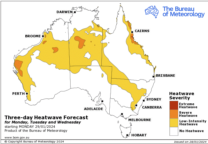
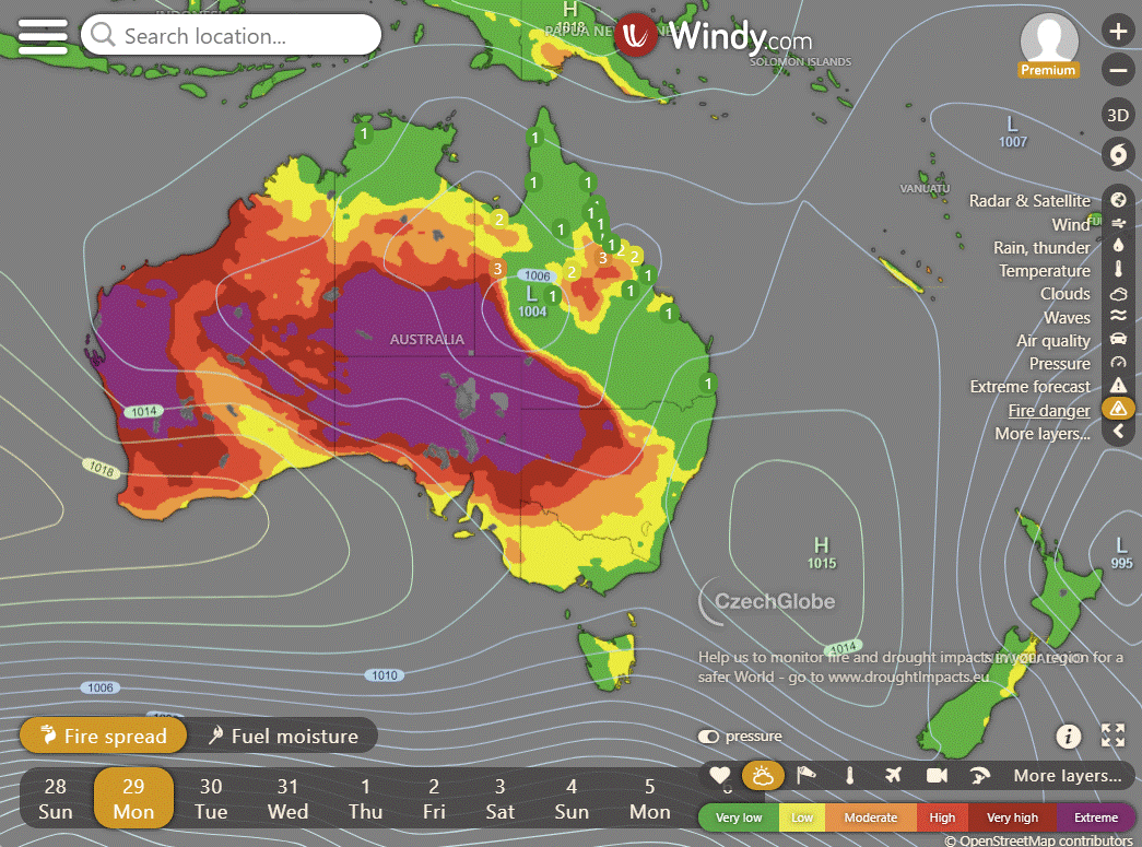
Storms - Heatwave - Fire danger
Click here to support to Wally's Weather
National maps by Weatherzone (weatherzone.com.au)
State maps by Windy (Windy.com)
Weather forecast supplemented by Bureau of Meteorology (bom.gov.au)
Rainfall daily totals (https://meteologix.com/ )
AccuWeather (https://www.accuweather.com/)
Nine Weather (https://www.9news.com.au/weather)
Wally's Weather provides professionally researched data and information. Andrew aka 'Wally' has over 20 years of experience in meteorology research and data analysis. In 2023 finished top 4 for the AMOS national weather forecasting competition. The content here is provided as educational information aimed at providing the community and businesses with the tools required to determine local-based forecasts. IMPORTANT: The forecasts and information posted should never be used on their own to make business decisions as local influences.





Comments